Métis-sur-Mer, Quebec
Métis-sur-Mer is a city in the La Mitis Regional County Municipality within the Bas-Saint-Laurent region of Quebec, Canada. It had a population of 607 in the Canada 2011 Census.[4]
Métis-sur-Mer | |
|---|---|
 | |
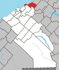 Location within La Mitis RCM | |
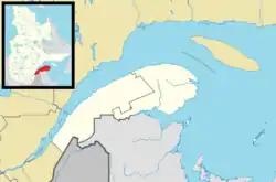 Métis-sur-Mer Location in eastern Quebec | |
| Coordinates: 48.67°N 68°W[1] | |
| Country | |
| Province | |
| Region | Bas-Saint-Laurent |
| RCM | La Mitis |
| Constituted | July 4, 2002 |
| Boroughs | MacNider |
| Government | |
| • Mayor | Jean-Pierre Pelletier |
| • Federal riding | Haute-Gaspésie—La Mitis—Matane—Matapédia |
| • Prov. riding | Matane-Matapédia |
| Area | |
| • Total | 263.70 km2 (101.82 sq mi) |
| • Land | 48.63 km2 (18.78 sq mi) |
| Population | |
| • Total | 607 |
| • Density | 12.4/km2 (32/sq mi) |
| • Pop 2006-2011 | |
| • Dwellings | 417 |
| Time zone | UTC−5 (EST) |
| • Summer (DST) | UTC−4 (EDT) |
| Postal code(s) | G0J 1S0 |
| Area code(s) | 418 and 581 |
| Highways | |
| Website | www |
Etymology
The name "Métis" is said to come from a Mi'kmaq word meaning "meeting place"; "sur-mer" refers to its location on the Saint Lawrence River.
History
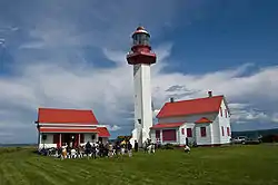
.jpg.webp)
From 1818, John MacNider, the Scottish Seigneur of Métis started settling the area with Scottish immigrants.
The city has a borough named MacNider, named after John MacNider family, whose territory corresponds to the former (pre-merger) village municipality of Métis-sur-Mer.(Metis Beach)[5][6]
At the end of the 19th century, wealthy anglophone Montrealers spent their time in Métis-sur-Mer to flee waves of cholera. At the beginning of the 20th century, they did so again to escape outbreaks of the Spanish flu. [7]
On July 4, 2002, the village of Métis-sur-Mer and the municipality of Les Boules merged to form the city of Métis-sur-Mer.[8]
Demographics
In the 2011 Census, Statistics Canada originally reported that Métis-sur-Mer had a population of 644 living in 298 of its 427 total dwellings, a 6.6% change from its 2006 population of 604.[9] Statistics Canada subsequently amended the 2011 census results to a population of 607 living in 288 of its 417 total dwellings, a 0.5% change from 2006.[4] With a land area of 48.63 km2 (18.78 sq mi), it had a population density of 12.482/km2 (32.328/sq mi) in 2011.[4][9]
See also
References
- Reference number 374643 of the Commission de toponymie du Québec (in French)
- Geographic code 09048 in the official Répertoire des municipalités (in French)
- "(Code 2409048) Census Profile". 2011 census. Statistics Canada. 2012.
- "Corrections and updates". Statistics Canada. 2012-09-19. Retrieved 2012-10-13.
- Geographic code REC01 in the official Répertoire des municipalités (in French)
- Reference number 377250 of the Commission de toponymie du Québec (in French)
- "À bras ouverts dans la distanciation physique". Le Devoir (in French). Retrieved 2020-06-23.
- http://www.stat.gouv.qc.ca/publications/referenc/pdf/modjuillet02.pdf%5B%5D
- "Population and dwelling counts, for Canada, provinces and territories, and census subdivisions (municipalities), 2011 and 2006 censuses (Quebec)". Statistics Canada. 2012-02-08. Retrieved 2012-10-13.
External links
 Media related to Métis-sur-Mer at Wikimedia Commons
Adjacent Municipal Subdivisions | |
|---|---|
| Cities & Towns | |
|---|---|
| Municipalities | |
| Parishes | |
| Villages | |
| Unorganized territories | |
| |
| Authority control |
|---|