La Matapédia Regional County Municipality
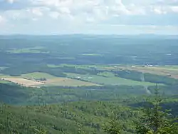
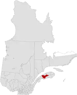
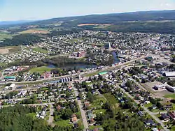
La Matapédia is a regional county municipality (RCM) in eastern Quebec, Canada at the base of the Gaspé peninsula, in the Bas-Saint-Laurent region. Its seat is in Amqui. It is named after the Matapédia River which runs through the western part of the RCM.
La Matapédia | |
|---|---|
 | |
 Flag | |
 | |
| Coordinates: 48°18′N 67°34′W[1] | |
| Country | |
| Province | |
| Region | Bas-Saint-Laurent |
| Effective | January 1, 1982 |
| County seat | Amqui |
| Government | |
| • Type | Prefecture |
| • Prefect | Chantale Lavoie |
| • Federal riding | Haute-Gaspésie—La Mitis—Matane—Matapédia |
| • Prov. riding | Matapédia |
| Area | |
| • Total | 5,389.00 km2 (2,080.70 sq mi) |
| • Land | 5,374.57 km2 (2,075.13 sq mi) |
| Population (2016)[3] | |
| • Total | 17,925 |
| • Density | 3.3/km2 (9/sq mi) |
| • Change 2011-2016 | |
| • Dwellings | 9,142 |
| Time zone | UTC−5 (EST) |
| • Summer (DST) | UTC−4 (EDT) |
| Area code(s) | 418 and 581 |
| Website | www |
La Matapédia was created on January 1, 1982, succeeding from the former Matapédia County Municipality. The region was subject to one of the last waves of colonization in Quebec, settled mostly by people from the Lower Saint-Lawrence between 1850 and 1950. It is a rural region in the Matapedia Valley crossed by the Notre Dame Mountains. Agriculture and logging, and its related industries (forestry and wood products), are the main economic activities.[1]
Subdivisions
There are 25 subdivisions within the RCM:[2]
|
|
|
|
|
Demographics
Population
| Canada census – La Matapédia Regional County Municipality, Quebec community profile | |||
|---|---|---|---|
| 2016 | 2011 | 2006 | |
| Population: | 17,925 (-3.5% from 2011) | 18,573 (-3.3% from 2006) | 19,199 (-3.6% from 2001) |
| Land area: | 5,374.57 km2 (2,075.13 sq mi) | 5,373.92 km2 (2,074.88 sq mi) | 5,373.92 km2 (2,074.88 sq mi) |
| Population density: | 3.3/km2 (8.5/sq mi) | 3.5/km2 (9.1/sq mi) | 3.6/km2 (9.3/sq mi) |
| Median age: | 50.6 (M: 50.1, F: 51.2) | 48.0 (M: 47.7, F: 48.2) | 44.5 (M: 44.5, F: 44.5) |
| Total private dwellings: | 9,142 | 9,116 | 9,015 |
| Median household income: | $47,488 | $42,628 | $36,550 |
| References: 2016[4] 2011[5] 2006[6] earlier[7] | |||
|
| ||||||||||||||||||||||||
| [8][3] | |||||||||||||||||||||||||
Language
| Canada Census Mother Tongue - La Matapédia Regional County Municipality, Quebec[8][3] | ||||||||||||||||||
|---|---|---|---|---|---|---|---|---|---|---|---|---|---|---|---|---|---|---|
| Census | Total | French |
English |
French & English |
Other | |||||||||||||
| Year | Responses | Count | Trend | Pop % | Count | Trend | Pop % | Count | Trend | Pop % | Count | Trend | Pop % | |||||
2016 |
17,790 |
17,635 | 99.13% | 70 | 0.39% | 35 | 0.20% | 50 | 0.28% | |||||||||
2011 |
18,345 |
18,215 | 99.29% | 75 | 0.41% | 30 | 0.16% | 25 | 0.14% | |||||||||
2006 |
18,810 |
18,665 | 99.23% | 55 | 0.29% | 10 | 0.05% | 80 | 0.43% | |||||||||
2001 |
19,405 |
19,320 | 99.56% | 35 | 0.18% | 40 | 0.21% | 10 | 0.05% | |||||||||
1996 |
20,435 |
20,280 | n/a | 99.24% | 60 | n/a | 0.29% | 70 | n/a | 0.34% | 25 | n/a | 0.12% | |||||
Transportation
Access Routes
Highways and numbered routes that run through the municipality, including external routes that start or finish at the county border:[9]
|
|
|
|
| Wikimedia Commons has media related to La Matapédia Regional County Municipality. |
References
- "La Matapédia (Municipalité régionale de comté)" (in French). Commission de toponymie du Québec. Retrieved 2012-02-06.
- "La Matapédia". Répertoire des municipalités (in French). Ministère des Affaires municipales, des Régions et de l'Occupation du territoire. Archived from the original on 2015-12-12. Retrieved 2012-02-06.
- "Census Profile, 2016 Census: La Matapédia, Municipalité régionale de comté [Census division], Quebec". Statistics Canada. Retrieved December 18, 2019.
- "2016 Community Profiles". 2016 Canadian Census. Statistics Canada. February 21, 2017. Retrieved 2019-12-18.
- "2011 Community Profiles". 2011 Canadian Census. Statistics Canada. July 5, 2013. Retrieved 2014-02-06.
- "2006 Community Profiles". 2006 Canadian Census. Statistics Canada. March 30, 2011. Retrieved 2014-02-06.
- "2001 Community Profiles". 2001 Canadian Census. Statistics Canada. February 17, 2012.
- Statistics Canada: 1996, 2001, 2006, 2011 census
- Official Transport Quebec Road Map
Adjacent Counties & Equivalent Territories | ||||||||||
|---|---|---|---|---|---|---|---|---|---|---|
| ||||||||||
| Regional county municipalities and equivalent territories | |
|---|---|
| Municipalities | |