M'Sila Province
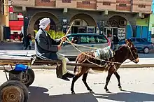
M'Sila (also spelled Msila, M'sila or MSila) (Arabic: المسيلة al-Masīla, Berber languages: ⵎⵙⵉⵍⴰ Msila) is a province (wilaya) of northern Algeria. It has a population of 1 million people and an area of 18,718 km², while its capital, also called M'sila, home to M'Sila University, has a population of about 100,000. Some localities in this wilaya are Bou Saada and Maadid. Chott El Hodna, a salt lake, crosses into M'Sila. However, most of the region is semi-arid and undeveloped.
M'Sila Province
ولاية المسيلة | |
|---|---|
.svg.png.webp) Map of Algeria highlighting M'Sila | |
| Coordinates: 35°42′N 4°33′E | |
| Country | |
| Capital | M'Sila |
| Area | |
| • Total | 18,718 km2 (7,227 sq mi) |
| Population (2008)[1] | |
| • Total | 991,846 |
| • Density | 53/km2 (140/sq mi) |
| Time zone | UTC+01 (CET) |
| Area Code | +213 (0) 35 |
| ISO 3166 code | DZ-28 |
| Districts | 15 |
| Municipalities | 47 |
Additionally, M'Sila was the location of the first village constructed as part of a government-run program to transition nomadic Algerians to sedentary life using local materials. The village, now complete, was dubbed Maader and consists of houses, public and trading areas, and a mosque.
History
The province was created from parts of Batna (département), Médéa (département) and Sétif (département) in 1974.
Administrative divisions
The province is divided into 15 districts (daïras), which are further divided into 47 communes or municipalities.
Districts
Communes
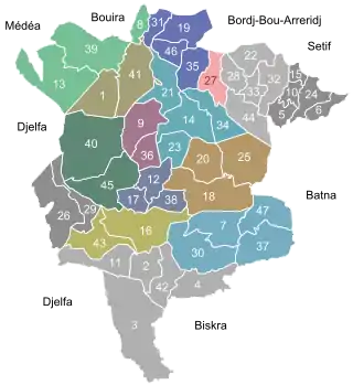
- 1. Aïn El Hadjel
- 2. Aïn El Melh
- 3. Aïn Errich
- 4. Aïn Fares
- 5. Aïn Khadra
- 6. Belaïba
- 7. Ben Srour
- 8. Beni Ilmane
- 9. Benzouh
- 10. Berhoum
- 11. Bir Foda
- 12. Bou-Saâda
- 13. Bouti Sayeh
- 14. Chellal
- 15. Dehahna
- 16. Djebel Messaad
- 17. El Hamel
- 18. El Houamed
- 19. Hammam Dhalaa
- 20. Khoubana
- 21. Khatouti Sed Eldjir
- 22. Maadid
- 23. Maarif
- 24. Magra
- 25. M'cif
- 26. Medjedel
- 27. M'sila
- 28. M'Tarfa
- 29. Menaa
- 30. Mohamed Boudiaf
- 31. Ouanougha
- 32. Ouled Addi Guebala
- 33. Ouled Derraj
- 34. Ouled Madhi
- 35. Ouled Mansour
- 36. Ouled Sidi Brahim
- 37. Ouled Slimane
- 38. Oultene
- 39. Sidi Aïssa
- 40. Sidi Ameur
- 41. Sidi Hadjeres
- 42. Sidi M'hamed
- 43. Slim
- 44. Souamaa
- 45. Tamsa
- 46. Tarmount
- 47. Zarzour
See also
References
- Office National des Statistiques, Recensement General de la Population et de l’Habitat 2008 Archived 2008-07-24 at the Wayback Machine Preliminary results of the 2008 population census. Accessed on 2008-07-02.
External links
- Encyclopaedia of the Orient - a brief description of M'Sila, focusing on its capital
- BBC - a news article about some recent violence in M'Sila
- Archnet - focuses on the Maader village project
- Wetlands International - an in-depth description of M'Sila's wetland
| Flag of Algeria | |