Mahakali, Darchula
Mahakali (Nepali: महाकाली) is a municipality located in Darchula District of Sudurpashchim province of Nepal. [1]
Mahakali
महाकाली | |
|---|---|
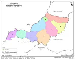
 Ward divisional map of Mahakali Municipality | |
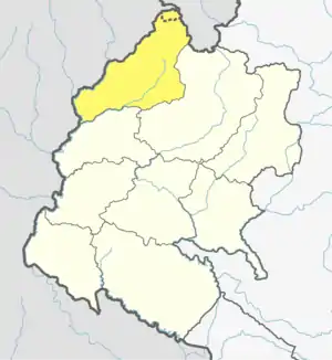
 Mahakali Location in Sudurpashchim  Mahakali Mahakali (Nepal) | |
| Coordinates: 29.83°N 80.55°E | |
| Country | Nepal |
| Province | Sudurpashchim Pradesh |
| District | Darchula |
| No. of wards | 9 |
| Established | 18 June 2014 |
| Incorporated (VDC) | Dattu |
| Incorporated (date) | 10 March, 2017 |
| Government | |
| • Type | Mayor–council |
| • Body | Mahakali Municipality |
| • Mayor | Mr. Hansraj Bhatta |
| • Deputy Mayor | Mrs. Suna Bohara |
| • MP & Constituency | Darchula 1 Ganesh Singh Thagunna (NCP) |
| • MLA & Constituency | Darchula 1(A) Gelbu Singh Bohara (NCP) |
| Area | |
| • Total | 135.11 km2 (52.17 sq mi) |
| Population (2011) | |
| • Total | 21,231 |
| Time zone | UTC+05:45 (NPT) |
| Website | mahakalimundarchula |
The municipality was established on 18 May 2014 named "Api Municipality" merging the former village development committees of: Brahmadev, Chhapari, Dhap, Kante and Khalanga.[2][3] The total area of "Api municipality" had 1,314 square kilometres (507 sq mi) and it had total population of 20,797 people.[4]
Fulfilling the requirement of the new Constitution of Nepal 2015, all old municipalities and villages (which were more than 3900 in number) were restructured into 753 new units, thus this municipality upgraded into Mahakali municipality[5] [6] [7]
On 10 March 2017, during upgradation of Api municipality a small portion of this municipality (ward 1, 2 & 3) excluded from it and Dattu Village development committee merged to it and renamed as Mahakali municipality. [8] Now total area of the municipality has 135.11 square kilometres (52.17 sq mi) and total population of it is 21231 people, the municipality is divided into total 9 wards.[8] [9]
References
- "स्थानीय तहहरुको विवरण" [Details of the local level bodies]. www.mofald.gov.np/en (in Nepali). Ministry of Federal Affairs and Local Development. Archived from the original on 31 August 2018. Retrieved 17 July 2018.
- 72 new municipalities announced Archived June 18, 2014, at the Wayback Machine My Republica
- Govt announces 72 new municipalities Archived 2014-10-06 at the Wayback Machine The Kathmandu Post
- "अपि नगरपालिकाको संक्षिप्त परिचय" [Short introduction of Api municipality] (PDF). apimun.gov.np. 17 January 2017. Retrieved 18 August 2018.
- "New local level structure comes into effect from today". www.thehimalayantimes.com. The Himalayan Times. 10 March 2017. Retrieved 17 July 2018.
- "Govt prepares to add 9 more local levels in Province 2". www.kathmandupost.ekantipur.com. Kantipur Publication. 11 August 2017. Retrieved 15 August 2018.
- "New local level units come into existence". www.kathmandupost.ekantipur.com. 11 March 2017. Retrieved 18 July 2018.
- "District Corrected Last for RAJAPATRA" (PDF). www.mofald.gov.np. Retrieved 17 July 2018.
- "CITY POPULATION – statistics, maps & charts". www.citypopulation.de. 10 August 2017. Retrieved 16 August 2018.

