Mahoning Creek (Allegheny River tributary)
Mahoning Creek is a tributary of the Allegheny River in Pennsylvania in the United States.[2]
| Mahoning Creek | |
|---|---|
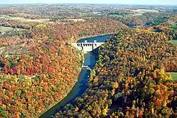 Mahoning Creek Lake and Dam on Mahoning Creek in Armstrong County, Pennsylvania | |
| Location | |
| Country | United States |
| Physical characteristics | |
| Source | |
| • coordinates | 40.9740°N 78.8565°W |
| • elevation | 1,293 ft (394 m) |
| Mouth | |
• coordinates | 40°55′59″N 79°27′42″W |
• elevation | 801 ft (244 m) |
| Discharge | |
| • location | Mahoning Creek Dam |
| • average | 694 cu ft/s (19.7 m3/s)[1] |
| Basin features | |
| River system | Allegheny River |
| Tributaries | |
| • left | East Branch Mahoning Creek, Jackson Run, Canoe Creek, Dutch Run, Carr Run, Little Mahoning Creek, Glade Run, Camp Run, Cave Run, Scrubgrass Creek |
| • right | Stump Creek, Rock Run, Graffius Run, Elk Run, Sawmill Run, Rose Run, Nicely Run, Perryville Run, Foundry Run, Steer Run, Hamilton Run, Sugarcamp Run, Foundry Run, Pine Run, Little Mudlick Creek, Cathcart Run, Hamilton Run |
Course
Portions of the Mahoning Creek watershed fall in Armstrong, Jefferson, and Indiana counties. The headwaters of Mahoning Creek are the East Branch Mahoning Creek and Stump Creek in Clearfield County. Mahoning Creek flows west through Pennsylvania and joins the Allegheny River just upstream of Templeton.
The creek can be divided into three sections:
- Upper Mahoning Creek, from the headwaters to Mahoning Creek Lake
- Mahoning Creek Lake, formed by Mahoning Creek Dam
- (Lower) Mahoning Creek, from the dam to the Allegheny River
The waterway is a popular destination for fly fishermen.
Tributaries
East Branch Mahoning Creek
| Name | Number | Bank | Mouth | Political subdivision | Source | Political subdivision |
|---|---|---|---|---|---|---|
| East Branch Mahoning Creek[4] | 0 | Left | 40°58′26″N 78°51′22″W (elev. 1,293 feet (394 m)) | Henderson Township, Jefferson County | 41°02′19″N 78°42′18″W | Brady Township, Clearfield County |
| Beech Run[34] | 1 | Left | 41°00′29″N 78°46′21″W (elev. 1,437 feet (438 m)) | Brady Township, Clearfield County | 40°59′52″N 78°42′31″W | Brady Township, Clearfield County |
| Beaver Run[35] | 2 | Right | 41°00′06″N 78°47′35″W (elev. 1,401 feet (427 m)) | Brady Township, Clearfield County | 41°01′34″N 78°47′33″W | Troutville |
| Laurel Run[36] | 3 | Left | 40°59′08″N 78°48′35″W (elev. 1,378 feet (420 m)) | Henderson Township, Jefferson County | 40°57′47″N 78°45′57″W | Bell Township, Clearfield County |
| Clover Run[37] | 4 | Left | 40°57′49″N 78°50′58″W (elev. 1,309 feet (399 m)) | Gaskill Township, Jefferson County | 40°56′15″N 78°47′19″W | Bell Township, Clearfield County |
Little Mahoning Creek
Pine Run
Political subdivisions
Mahoning Creek traverses the following political subdivisions, listed in order of encounter traveling downstream,
- Henderson Township, Jefferson County
- Big Run
- Bell Township, Jefferson County
- Punxsutawney
- Perry Township, Jefferson County
- West Mahoning Township, Indiana County
- Wayne Township, Armstrong County
- Redbank Township, Armstrong County
- Mahoning Township, Armstrong County
- Pine Township, Armstrong County
East Branch Mahoning Creek traverses the following political subdivisions, listed in order of encounter traveling downstream.
- Brady Township, Clearfield County
- Henderson Township, Jefferson County
- Gaskill Township, Jefferson County
Little Mahoning Creek traverses the following political subdivisions, listed in order of encounter traveling downstream.
- Green Township, Indiana County
- Grant Township, Indiana County
- Canoe Township, Indiana County
- East Mahoning Township, Indiana County
- North Mahoning Township, Indiana County
- South Mahoning Township, Indiana County
- West Mahoning Township, Indiana County
Pine Run traverses the following political subdivisions, listed in order of encounter traveling downstream,
See also
References
- https://waterdata.usgs.gov/pa/nwis/annual/?format=sites_selection_links&search_site_no=03036000&agency_cd=USGS&referred_module=sw
- "Mahoning Creek". Geographic Names Information System. United States Geological Survey. Retrieved 2011-04-18.
- "Mahoning Creek, Armstrong County, Pennsylvania". Geographic Names Information System. United States Geological Survey.
- "East Branch Mahoning Creek, Jefferson County, Pennsylvania". Geographic Names Information System. United States Geological Survey.
- "Stump Creek, Jefferson County, Pennsylvania". Geographic Names Information System. United States Geological Survey.
- "Big Run, Jefferson County, Pennsylvania". Geographic Names Information System. United States Geological Survey.
- "Rock Run, Jefferson County, Pennsylvania". Geographic Names Information System. United States Geological Survey.
- "Graffius Run, Jefferson County, Pennsylvania". Geographic Names Information System. United States Geological Survey.
- "Jackson Run, Jefferson County, Pennsylvania". Geographic Names Information System. United States Geological Survey.
- "Canoe Creek, Jefferson County, Pennsylvania". Geographic Names Information System. United States Geological Survey.
- "Elk Run, Jefferson County, Pennsylvania". Geographic Names Information System. United States Geological Survey.
- "Sawmill Run, Jefferson County, Pennsylvania". Geographic Names Information System. United States Geological Survey.
- "Rose Run, Jefferson County, Pennsylvania". Geographic Names Information System. United States Geological Survey.
- "Nicely Run, Jefferson County, Pennsylvania". Geographic Names Information System. United States Geological Survey.
- "Dutch Run, Jefferson County, Pennsylvania". Geographic Names Information System. United States Geological Survey.
- "Perryville Run, Jefferson County, Pennsylvania". Geographic Names Information System. United States Geological Survey.
- "Foundry Run, Jefferson County, Pennsylvania". Geographic Names Information System. United States Geological Survey.
- "Steer Run, Indiana County, Pennsylvania". Geographic Names Information System. United States Geological Survey.
- "Carr Run, Indiana County, Pennsylvania". Geographic Names Information System. United States Geological Survey.
- "Hamilton Run, Indiana County, Pennsylvania". Geographic Names Information System. United States Geological Survey.
- "Sugarcamp Run, Indiana County, Pennsylvania". Geographic Names Information System. United States Geological Survey.
- "Little Mahoning Creek, Indiana County, Pennsylvania". Geographic Names Information System. United States Geological Survey.
- "Foundry Run, Armstrong County, Pennsylvania". Geographic Names Information System. United States Geological Survey.
- "Mahoning Creek Lake, Armstrong County, Pennsylvania". Geographic Names Information System. United States Geological Survey.
- "Glade Run, Armstrong County, Pennsylvania". Geographic Names Information System. United States Geological Survey.
- "Mahoning Creek Dam, Armstrong County, Pennsylvania". Geographic Names Information System. United States Geological Survey.
- "Camp Run, Armstrong County, Pennsylvania". Geographic Names Information System. United States Geological Survey.
- "Pine Run, Armstrong County, Pennsylvania". Geographic Names Information System. United States Geological Survey.
- "Little Mudlick Creek, Armstrong County, Pennsylvania". Geographic Names Information System. United States Geological Survey.
- "Cathcart Run, Armstrong County, Pennsylvania". Geographic Names Information System. United States Geological Survey.
- "Hamilton Run, Armstrong County, Pennsylvania". Geographic Names Information System. United States Geological Survey.
- "Cave Run, Armstrong County, Pennsylvania". Geographic Names Information System. United States Geological Survey.
- "Scrubgrass Creek, Armstrong County, Pennsylvania". Geographic Names Information System. United States Geological Survey.
- "Beech Run, Clearfield County, Pennsylvania". Geographic Names Information System. United States Geological Survey.
- "Beaver Run, Clearfield County, Pennsylvania". Geographic Names Information System. United States Geological Survey.
- "Laurel Run, Jefferson County, Pennsylvania". Geographic Names Information System. United States Geological Survey.
- "Clover Run, Jefferson County, Pennsylvania". Geographic Names Information System. United States Geological Survey.
- "East Run, Indiana County, Pennsylvania". Geographic Names Information System. United States Geological Survey.
- "Rairigh Run, Indiana County, Pennsylvania". Geographic Names Information System. United States Geological Survey.
- "Straight Run, Indiana County, Pennsylvania". Geographic Names Information System. United States Geological Survey.
- "Rishell Run, Indiana County, Pennsylvania". Geographic Names Information System. United States Geological Survey.
- "Barrett Run, Indiana County, Pennsylvania". Geographic Names Information System. United States Geological Survey.
- "Brewer Run, Indiana County, Pennsylvania". Geographic Names Information System. United States Geological Survey.
- "Broadhead Run, Indiana County, Pennsylvania". Geographic Names Information System. United States Geological Survey.
- "Crooked Run, Indiana County, Pennsylvania". Geographic Names Information System. United States Geological Survey.
- "Leasure Run, Indiana County, Pennsylvania". Geographic Names Information System. United States Geological Survey.
- "Pickering Run, Indiana County, Pennsylvania". Geographic Names Information System. United States Geological Survey.
- "Mudlick Run, Indiana County, Pennsylvania". Geographic Names Information System. United States Geological Survey.
- "Ross Run, Indiana County, Pennsylvania". Geographic Names Information System. United States Geological Survey.
- "Middle Branch Pine Run, Jefferson County, Pennsylvania". Geographic Names Information System. United States Geological Survey.
- "Caylor Run, Jefferson County, Pennsylvania". Geographic Names Information System. United States Geological Survey.
- "Eagle Run, Jefferson County, Pennsylvania". Geographic Names Information System. United States Geological Survey.
- "Painter Run, Jefferson County, Pennsylvania". Geographic Names Information System. United States Geological Survey.
- "Nye Branch, Armstrong County, Pennsylvania". Geographic Names Information System. United States Geological Survey.
- "Sugarcamp Run, Armstrong County, Pennsylvania". Geographic Names Information System. United States Geological Survey.
- "Mudlick Creek, Armstrong County, Pennsylvania". Geographic Names Information System. United States Geological Survey.
