Mahoning River
The Mahoning River[1] is a river located in northeastern Ohio and a small portion of western Pennsylvania. Flowing primarily through several Ohio counties, it then crosses the state line into Pennsylvania before joining with the Shenango River to form the Beaver River. The Mahoning River drops from 1,296 feet (395 m)[1] at the headwaters near Winona to 761 feet (232 m)[1] at the outfall near Mahoningtown. It is part of the Ohio River watershed.
| Mahoning River | |
|---|---|
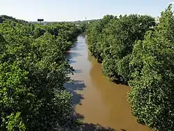 The Mahoning River in Youngstown, Ohio | |
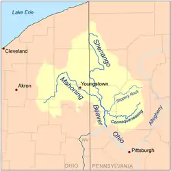 Map of the Beaver River watershed including the Mahoning River | |
| Location | |
| Country | United States |
| States | Ohio, Pennsylvania |
| Physical characteristics | |
| Source | |
| • location | One half mile southwest of Winona, Ohio |
| • coordinates | 40°49′18″N 80°54′12″W[1] |
| • elevation | 395 m (1,296 ft) above sea level[2] |
| Mouth | Beaver River |
• location | near Mahoningtown, New Castle, Pennsylvania |
• coordinates | 40°57′29″N 80°22′43″W[1] |
• elevation | 232 m (761 ft) above sea level[1] |
| Length | 182 km (113 mi)[3] |
| Basin size | 2,932 km2 (1,132 sq mi) |
| Discharge | |
| • average | 54 m3/s (1,900 cu ft/s)[3] |
Hydronymy
The name comes from Lenape mahonink, meaning "at the licks" or "there is a lick", referring to salt licks in the area.[4][5]
Physical properties

The river is formed near Winona in Columbiana County, Ohio, and extends for a length of approximately 113 miles (182 km), with a watershed area of approximately 1,132 square miles (2,932 km²). It joins the Shenango River near Mahoningtown, Pennsylvania south of New Castle to form the Beaver River. The river traverses five Ohio counties,[1] Columbiana, Stark, Portage, Trumbull, and Mahoning, as well as Lawrence County, Pennsylvania. The watershed area also includes parts of Ashtabula and Geauga counties in Ohio.
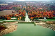
The three main tributaries are Mosquito Creek, West Branch, and Eagle Creek, all in Ohio. There are 15 dams on the river course. The river has a course of 97.1 miles (156.3 km) in Ohio, with the remainder in Pennsylvania.
The river supports more than 72 species of fish and 15 species of freshwater mussels.
The river is roughly divided into two sections based on its own character and its surroundings. In addition to the change in terrain address in the section on "Floods", the level of human development changes dramatically as well. The “upper elevation” flowing north and east extends roughly from Winona to Leavittsburg and is generally rural in nature, meandering through game lands, forests, and agricultural properties. The mainstem (lower elevation) flowing mainly southeast extends roughly from Leavittsburg to the river's mouth near New Castle, Pennsylvania. Portions of this section are more densely populated and heavily industrialized, including the cities of Warren, Niles, Youngstown, Campbell, and others. The area suffers with residue from all the industrial activity that began in the late 19th century. The mainstem area has a population of over 500,000 and has a long history of steel making, coke production, and other industries.
Environmental concerns
The industrial nature of the mainstem area has caused considerable pollution in the river. Much of the pollution has left the ecosystem via the natural river flow. But analysts estimate that 750,000 cubic yards (573,416 m³) of river bed and shoreline sediment, over a 30-mile (48.2 km) stretch of the mainstem from Leavittsburg to the Pennsylvania border, is so heavily polluted that it will need to be remediated. Approximately 45% of this material is located in the vicinity of the Girard Dam near Girard, Ohio, which has acted as a trap for much of the contaminated sediment.
Petroleum hydrocarbons, benzo(a)pyrene (polycyclic aromatic hydrocarbons), and mercury have all been found in quantities several times the maximum safe levels. Since 1988, the Ohio Department of Health has maintained an advisory against swimming or wading in the river between Leavittsburg and the Pennsylvania border, and also advises against eating fish caught there. The Corps of Engineers estimates that the remediation will take up to 15 years to complete and cost in excess of US$100 million.
Cities and towns along its course include:
Floods
The Mahoning river is susceptible to frequent flooding during high rain events. One such event started when three days of torrential rain fell in July 2003,[6] resulting in such high volume that the river changed its course in Leavittsburg, flooding and destroying nearly 100 homes. For much of the upper half of the river, the land is relatively flat with minimal relief to confine the river making it prone to change courses during high-water events. Around Youngstown, the river valley becomes much more pronounced and the river is more constrained, although there is still room for localized avulsions.
References
- U.S. Geological Survey Geographic Names Information System: Mahoning River
- Hanoverton, OH, 7.5 Minute Topographic Quadrangle, USGS, 1994 (1997 rev.)
- mahoningriver,com (dead link)
- "Ohio County Name Origins" (PDF). Ohio Secretary of State. Archived from the original (PDF) on 12 July 2013. Retrieved 25 February 2019.
- Gannett, Henry (1905). The Origin of Certain Place Names in the United States. U.S. Government Printing Office. p. 196.
- "Mahoning River Watershed Action Plan" (PDF). Youngstown State University.(dead link)
External links
- Archived version of Youngstown State University's Mahoning River Watershed website
- Archived version of Mahoning River Consortium website
| Authority control |
|---|