Warren, Ohio
Warren is a city in and the county seat of Trumbull County, Ohio, United States.[5] The municipality is located in northeastern Ohio, approximately 14 miles (23 km) northwest of Youngstown and 56 miles (90 km) southeast of Cleveland.
Warren, Ohio | |
|---|---|
| City of Warren | |
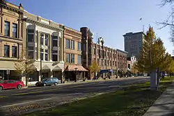 Downtown Warren | |
| Motto(s): "Historic Capital of the Western Reserve" | |
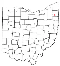 Location within the state of Ohio | |
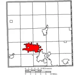 Location of Warren in Trumbull County | |
| Coordinates: 41°14′18″N 80°48′52″W | |
| Country | United States |
| State | Ohio |
| County | Trumbull |
| Founded | 1798 |
| Government | |
| • Mayor | William D. Franklin |
| Area | |
| • City | 16.13 sq mi (41.77 km2) |
| • Land | 15.97 sq mi (41.35 km2) |
| • Water | 0.16 sq mi (0.42 km2) |
| Elevation | 892 ft (272 m) |
| Population | |
| • City | 41,558 |
| • Estimate (2019)[3] | 38,752 |
| • Density | 2,427.16/sq mi (937.12/km2) |
| • Metro | 565,773 |
| Time zone | UTC-5 (EST) |
| • Summer (DST) | UTC-4 (EDT) |
| ZIP codes | 44481-44488 |
| Area code(s) | 330 234 |
| FIPS code | 39-80892 |
| GNIS feature ID | 1084083[4] |
| Website | https://www.warren.org/ |
The population was 41,558 at the 2010 census. Warren is the second largest city in the Youngstown-Warren-Boardman, OH-PA Metropolitan Statistical Area, and anchors the northern part of that area.
History
Ephraim Quinby founded Warren in 1798, on 441 acres (1.78 km2) of land that he purchased from the Connecticut Land Company, as part of the Connecticut Western Reserve. Quinby named the town for the town's surveyor, Moses Warren. The town was the county seat of the Western Reserve, then became the Trumbull County seat in 1801.[6]
In 1833, Warren contained county buildings, two printing offices, a bank, five mercantile stores, and about 600 inhabitants.[7]
Warren had a population of nearly 1,600 people in 1846. In that same year the town had five churches, twenty stores, three newspaper offices, one bank, one woolen factory and two flourmills. In June 1846, a fire destroyed several buildings on one side of the town square, but residents soon replaced them with new stores and other businesses. Warren became an important center of trade for farmers living in the surrounding countryside during this period. Songwriter Stephen Foster, his wife Jane McDowell, and their daughter Marion lived briefly in Warren.
During the latter decades of the nineteenth century and throughout the twentieth century, Warren remained an important trading and manufacturing center. By 1888, four railroads connected the community with other parts of Ohio. In that same year, there were five newspaper offices, seven churches, three banks and numerous manufacturing firms in Warren. The businesses manufactured a wide variety of products including linseed oil, furniture, barrel staves, wool fabric, blinds, incandescent bulbs, automobiles[8] and carriages. Warren was the first town in the US to have an electric street illumination, provided by the Packard Electric Company, founded 1890 in Warren.[8] Warren's population was 5,973 people in 1890. Construction began on the Trumbull County Courthouse in downtown Warren on Thanksgiving Day, 1895.[9]
Warren continued to grow in the twentieth century. During the late nineteenth and early twentieth centuries, steel production was a major industry in the county because of large deposits of coal and iron ore in surrounding counties. In recent years, many Warren residents have worked in local service and retail sales businesses. In 2000, Warren was Trumbull County's most populated community, with 46,832 residents. Many examples of late 19th and early 20th century architectural styles still stand in downtown Warren, including the Trumbull County Courthouse, which contains one of the largest courtrooms in the state of Ohio and the Trumbull County Carnegie Law Library in addition to office buildings, banks, stores, and homes surrounding the Courthouse Square area.[10]
Economy
Major employers in Warren include Trumbull Memorial Hospital, St. Joseph Warren Hospital, the Tribune Chronicle, Seven Seventeen Credit Union, and Hillside Rehabilitation Hospital. Thomas Steel Strip. Ajax TOCCO is located outside city limits.[11]
Geography
Warren is located at 41°14′18″N 80°48′52″W (41.238206, −80.814554).[12]
According to the United States Census Bureau, the city has a total area of 16.16 square miles (41.85 km2), of which 16.13 square miles (41.78 km2) is land and 0.03 square miles (0.08 km2) is water.[13]
Demographics
| Historical population | |||
|---|---|---|---|
| Census | Pop. | %± | |
| 1820 | 435 | — | |
| 1830 | 501 | 15.2% | |
| 1840 | 1,066 | 112.8% | |
| 1860 | 2,402 | — | |
| 1870 | 3,457 | 43.9% | |
| 1880 | 4,428 | 28.1% | |
| 1890 | 5,973 | 34.9% | |
| 1900 | 8,529 | 42.8% | |
| 1910 | 11,081 | 29.9% | |
| 1920 | 27,050 | 144.1% | |
| 1930 | 41,062 | 51.8% | |
| 1940 | 42,837 | 4.3% | |
| 1950 | 49,856 | 16.4% | |
| 1960 | 59,648 | 19.6% | |
| 1970 | 63,494 | 6.4% | |
| 1980 | 56,629 | −10.8% | |
| 1990 | 50,793 | −10.3% | |
| 2000 | 46,832 | −7.8% | |
| 2010 | 41,558 | −11.3% | |
| 2019 (est.) | 38,752 | [3] | −6.8% |
| U.S. Decennial Census[14] | |||
95.5% spoke English, 1.6% Greek, 1.1% Spanish, and 0.9% Italian in their homes.[15]
2010 census
As of the census[2] of 2010, there were 41,557 people, 17,003 households, and 10,013 families living in the city. The population density was 2,576.4 inhabitants per square mile (994.8/km2). There were 20,384 housing units at an average density of 1,263.7 per square mile (487.9/km2). The racial makeup of the city was 67.7% White, 27.7% African American, 0.2% Native American, 0.4% Asian, 0.7% from other races, and 3.3% from two or more races. Hispanic or Latino of any race were 1.9% of the population.
Of the 17,003 households 29.8% had children under the age of 18 living with them, 31.8% were married couples living together, 21.3% had a female householder with no husband present, 5.8% had a male householder with no wife present, and 41.1% were non-families. 35.6% of households were one person and 13.8% were one person aged 65 or older. The average household size was 2.30 and the average family size was 2.97.
The median age was 38.3 years. 23.7% of residents were under the age of 18; 9.3% were between the ages of 18 and 24; 25.2% were from 25 to 44; 25.9% were from 45 to 64; and 16% were 65 or older. The gender makeup of the city was 48.1% male and 51.9% female.
2000 census
At the 2000 census, there were 46,832 people, 19,288 households and 12,035 families living in the city. The population density was 2,912.4 people per square mile (1,124.5/km2). There were 21,279 housing units at an average density of 1,322.9 per square mile (510.9/km2). The racial makeup of the city was 60.94% White, 36.20% African American, 0.13% Native American, 0.42% Asian, 0.03% Pacific Islander, 0.30% from other races and 1.98% from two or more races. Hispanic or Latino of any race were 1.04% of the population.
Of the 19,288 households 29.5% had children under the age of 18 living with them, 38.4% were married couples living together, 19.4% had a female householder with no husband present and 37.6% were non-families. 32.9% of households were one person and 13.7% were one person aged 65 or older. The average household size was 2.37 and the average family size was 3.01.
The age distribution was 26.3% under the age of 18, 8.6% from 18–24, 27.3% from 25–44, 21.0% from 45–64 and 16.8% 65 or older. The median age was 36 years. For every 100 females, there were 86.8 males. For every 100 females age 18 and over, there were 81.9 males.
The median household income was $30,147 and the median family income was $36,158. Males had a median income of $32,317 versus $23,790 for females. The per capita income for the city was $16,808. About 16.2% of families and 19.4% of the population were below the poverty line, including 29.8% of those under age 18 and 9.9% of those age 65 or over.
Notable people
- Roger Ailes
- Red Ames (former Major League Baseball player)
- David Arnold (University of Michigan and NFL football player)
- Catherine Bach (actress)
- James L. Baughman (historian)
- Andrew John Berger (ornithologist)
- Carolina Bermudez (radio personality on Elvis Duran and the Morning Show in New York)
- Earl Derr Biggers (novelist and playwright)
- Bud Boone (auto racer)
- Aaron Brown (linebacker) (Ohio State University and NFL football player)
- Joey Browner (USC and NFL football player)
- Keith Browner (USC and NFL football player)
- Ross Browner (Notre Dame and NFL football player, College Football Hall of Famer)
- Prescott Burgess (University of Michigan and National Football League player with Baltimore Ravens)
- Michael Capellas (former CEO Of Compaq Computer Corporation)
- Genevieve R. Cline (federal judge)
- Chris Columbus (filmmaker)
- Kenyon Cox (American painter, illustrator, muralist, writer and teacher)
- Joseph S. Curtis (Wisconsin State Assemblyman and lawyer)[16]
- Doug Datish (Ohio State University and NFL football player)
- Alaska Packard Davidson (First Female FBI special agent)[17]
- Van DeCree (Ohio State University and World Football League player)
- Linda DeScenna, film set decorator
- Jerry Douglas (Grammy Award-winning musician)
- Elizabeth George (novelist, creator of The Inspector Lynley Mysteries)
- Randy Gradishar (Ohio State University and NFL football player)
- Dave Grohl (rock musician in Nirvana, Foo Fighters, Queens of the Stone Age and Them Crooked Vultures)
- John Harsh, Wisconsin State Assembly[18]
- David Herron (linebacker for the NFL Kansas City Chiefs)
- Hugh Hewitt (radio talk show host)
- Sean Jones (jazz musician, composer, lead trumpeter for Jazz at Lincoln Center Orchestra)
- Jason Kokrak (professional golfer – PGA Tour)
- Bill Kollar (Montana State and NFL football player, NFL assistant coach)
- Rex Lee (actor, HBO's Entourage)
- Braeden Lemasters (actor)
- Mario Manningham (University of Michigan and San Francisco 49ers football player)
- Robin McKinley (fantasy author)
- Antwaun Molden (cornerback for the New England Patriots)
- James Ward Packard and brother William Doud Packard (industrialists)[8]
- Johnny Ace Palmer (magician)
- Ronald A. Parise (NASA astronaut)
- Austin Pendleton (actor)
- Greg Reeves (musician)
- Carl Schmitt (artist and writer)
- Davion Allen (Pizza Porter)
- De'Veon Smith (Running Back, Miami Dolphins, NFL)
- Karl Singer (football player)
- Korey Stringer (NFL player)
- Tere Tereba (fashion designer, actress, writer)
- Harriet Taylor Upton (first woman vice-chairman of the Republican National Committee)
- Paul Warfield (Ohio State University and NFL football player, NFL Hall of Famer)
- Forrest Wilson (winner of the Pulitzer Prize for Biography or Autobiography)
- Chris Zylka (actor, The Secret Circle)
References
- "2019 U.S. Gazetteer Files". United States Census Bureau. Retrieved July 28, 2020.
- "U.S. Census website". United States Census Bureau. Retrieved January 6, 2013.
- "Population and Housing Unit Estimates". Retrieved May 21, 2020.
- "US Board on Geographic Names". United States Geological Survey. October 25, 2007. Retrieved January 31, 2008.
- "Find a County". National Association of Counties. Retrieved June 7, 2011.
- About Warren: "Early History" Archived February 10, 2009, at the Wayback Machine, City of Warren, Ohio
- Kilbourn, John (1833). The Ohio Gazetteer, or, a Topographical Dictionary. Scott and Wright. pp. 468. Retrieved December 12, 2013.
- Kimes, Beverly Rae, ed. (1978). "Packard, a history of the motor car and the company". Automobile Quarterly (General ed.). ISBN 0-915038-11-0.
- "Trumbull County Courthouse". Trumbull County, Ohio. Archived from the original on September 29, 2011. Retrieved July 7, 2015.
- "Trumbull County Carnegie Law Library". Trumbull County, Ohio. Archived from the original on July 20, 2011. Retrieved July 7, 2015.
- Search Results - Warren, Ohio - ReferenceUSA Current Businesses
- "US Gazetteer files: 2010, 2000, and 1990". United States Census Bureau. February 12, 2011. Retrieved April 23, 2011.
- "US Gazetteer files 2010". United States Census Bureau. Archived from the original on July 2, 2012. Retrieved January 6, 2013.
- "Census of Population and Housing". Census.gov. Retrieved June 4, 2015.
- "Warren, Ohio". Modern Language Association. Retrieved July 7, 2015.
- "Biographical Sketch of Joseph Seaver Curtis". Wisconsin Blue Book. 1873. p. 440.
- https://amazingwomeninhistory.com/alaska-p-davidson-first-female-fbi-agent/
- "Biographical Sketch of John Harsh". Wisconsin Blue Book. 1875. p. 319.
External links
| Wikimedia Commons has media related to Warren, Ohio. |
Municipalities and communities of Trumbull County, Ohio, United States | ||
|---|---|---|
| Cities |  Map of Ohio highlighting Trumbull County | |
| Villages | ||
| Townships | ||
| CDPs | ||
| Unincorporated communities | ||
| Footnotes | ‡This populated place also has portions in an adjacent county or counties | |
| ||
Places adjacent to Warren, Ohio | ||||||||||
|---|---|---|---|---|---|---|---|---|---|---|
| ||||||||||
Great Lakes megaregion as defined by RPA | ||
|---|---|---|
Note: A few Great Lakes regions cities in Canada are left out. Metropolitan areas have +150,000 according to source at the time estimated. | ||
| Great Lakes region cities |  | |
| Surrounding cities |
| |
| Cities of states south of region | ||
| Other metro-regions | ||
| Authority control |
|---|