Malad
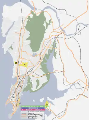
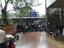
Malad is a suburb located in North Mumbai. Malad has a railway station on the Western line (Mumbai Suburban Railway) of the Mumbai Suburban Railway, lying between Kandivali station to the north and Goregaon station to the south. The railway tracks of the Western Line divide Malad into Malad (West) and Malad (East). Also located in Malad is a prominent office commercial space extending from the back of the two prominent shopping malls Inorbit Mall & Infiniti Mall.
Malad | |
|---|---|
Suburb | |
 Inorbit Mall, Malad | |
 Malad  Malad  Malad | |
| Coordinates: 19.186111°N 72.848611°E | |
| Country | India |
| State | Maharashtra |
| District | Mumbai Suburban |
| City | Mumbai |
| Zone | D.C.P, Zone IX |
| Ward | P-North |
| Government | |
| • Type | Municipal Corporation |
| • Body | Brihanmumbai Municipal Corporation (MCGM) |
| Languages | |
| • Official | Marathi |
| Time zone | UTC+5:30 (IST) |
| PIN | 400064(West), 400095(Malvani), 400097(East) |
| Area code(s) | 022 |
| Lok Sabha Constituency | Mumbai North |
History
In the 16th century, Malad consisted of a number of villages including Orlem (also known as Valnai), Kharodi, Rathodi, Malwani, Marve, Aksa, Madh and Chincholi. The other old settlements in Malad were villages occupied by the local SKP community, East Indian Community, Bhandaris and Kolis - who are recognized as the original native inhabitants of Mumbai ,these communities are still living in Malad.
Ahead of Aksa Beach, is the hidden and relatively lesser known vital landmark, which is the Malad Fort a.k.a. Madh Fort. The fort overlooks the Arabian Sea and was captured by the Maratha Empire, from the Portuguese in 1739.[1] INS Hamla, a logistics and training establishment of the Indian navy is situated in Malad.[2]
Demographics
The approximate population is approx 946,000 with an additional day-time floating population of 100,000. Malad which in its entirety (East & West region) comes under the P-North ward which is the most populated ward in the city, according to the census 2011.
Educational Institutes
- Kendriya Vidyalaya INS Hamla
- St Joseph's High School
- Children's Academy group of schools (Bachani Nagar branch)
- Carmel of st. Joseph school (SSC, Malad)
- St. Anthony's High School
- Dr. Sarvepalli Radhakrishnan International School
- Veer Bhagat Singh Vidhyalaya
- N.L. Dalmia college
- Durgadevi Saraf Institute of Management Studies[3]
- Mahindra Academy[4]
- Lords Universal College[5]
- Ryan International School (ICSE/SSC, Malad)[6]
- Ryan International School (CBSE, Malad)
- Seth Juggilal Poddar Academy[7]
- Balbharti School
- Gyanganga Infotech Computer Institute (Malad East)
- St. Anne's High School & Junior College[8]
- Ramzan Ali English School & Junior College
- Kala Vidyalaya school & Polytechnic
- Utkarsh Mandir high school
- St Jude's High School
- Infant Jesus school
- st. George high school
Beaches
- Marve Beach
- Aksa Beach
- Danapani Beach
- Erangal Beach
- Madh Beach
- Manori Beach
References
- "Colonial Voyage - The website dedicated to the Colonial History". Colonial Voyage. Archived from the original on 25 April 2009. Retrieved 30 November 2017.
- "Indian Navy". 30 January 2012. Archived from the original on 30 January 2012. Retrieved 18 January 2019.
- "Top B schools | DSIMS | Durgadevi Saraf Institute of Management Studies". www.rset.edu.in. Retrieved 18 January 2019.
- mahindraacademy.org. "Mahindra Acedemy". Retrieved 18 January 2019.
- "Home". Lords Universal College, Goregaon. 12 January 2012. Retrieved 18 January 2019.
- "Ryan International School: Malad". www.ryaninternational.org. Retrieved 18 January 2019.
- "Home". Seth Juggilal Poddar Academy, Malad. 12 January 2012. Retrieved 18 January 2019.
- "St. Anne's High School & Junior College". sahsjc.org. Retrieved 8 March 2019.
| Wikimedia Commons has media related to Malad. |
Malad Culture
