Eastern Suburbs (Mumbai)
East Mumbai consists the localities of Bhandup, Ghatkopar, Kanjurmarg, Kurla, Mulund, Nahur, Powai, Vidyavihar and Vikhroli. To the south-east lie the neighborhoods of Chembur, Govandi, Mankhurd, Trombay and Wadala.
East Mumbai | |
|---|---|
Precinct of Mumbai | |
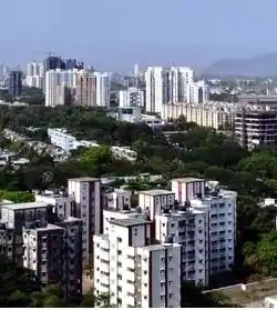 View of Kanjurmarg looking South West | |
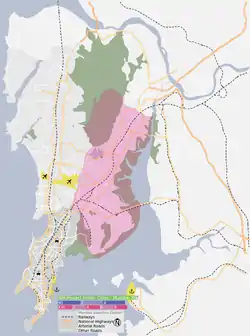 Eastern Suburbs precinct is shown in pink | |
 Mumbai Eastern Suburbs Mumbai Eastern Suburbs  Mumbai Eastern Suburbs Mumbai Eastern Suburbs (Maharashtra)  Mumbai Eastern Suburbs Mumbai Eastern Suburbs (Mumbai) | |
| Coordinates (Kanjurmarg): 19.13°N 72.94°E | |
| Country | India |
| State | Maharashtra |
| City | Mumbai |
| Wards | L, ME, MW, N, S, T |
| Area | |
| • Total | 203.3 km2 (78.5 sq mi) |
| Population (2011) | |
| • Total | 4,160,000 |
| • Density | 20,000/km2 (53,000/sq mi) |
| Time zone | UTC+5:30 (IST) |
| Eastern Suburbs: Population Growth | |||
|---|---|---|---|
| Census | Population | %± | |
| 1971 | 1,194,710 | — | |
| 1981 | 2,100,220 | 75.8% | |
| 1991 | 2,803,030 | 33.5% | |
| 2001 | 3,491,890 | 24.6% | |
| Est. 2011 | 4,160,000 | 19.1% | |
| Source: MMRDA[1] Data is based on Government of India Census. | |||
Division
The city of Mumbai lies on Salsette Island. The long thinner protruding landmass just across the Mithi river is the oldest part of the city. This region is called South Mumbai. The area just north of Mithi river is called West Mumbai and the area that lies to the east of the airport is called East Mumbai. North Mumbai is further upwards just across the JVLR which is primarily a residential part of the city
Transport
Rail
East Mumbai is served by the Central Line. With the exception of Powai, each of the neighborhoods has a railway station. Kurla is an interchange point for the Harbour Line.
Road
The Eastern Express Highway (EEH) is a major road the runs along the border of East Mumbai.
Lal Bahadur Shastri Marg (LBS Marg) is a 21 km long, major arterial road in the East Mumbai. LBS Marg connects the neighbouring city of Thane with the neighbourhood of Sion in Mumbai.
However, connectivity from the Western part of the city is poor. The Andheri-Ghatkopar Link Road, Jogeshwari - Vikhroli Link Road (JVLR) and the Andheri-Kurla Road are the major road links between the Eastern and Western neighbourhoods. Santa Cruz – Chembur Link Road (SCLR) which was completed in April 2014 links Santa Cruz to Chembur.
Bus services are provided by Brihanmumbai Electric Supply and Transport (BEST). There are bus depots at Ghatkopar, Mulund and Vikhroli.
See also
References
Notes
- "Population and Employment profile of Mumbai Metropolitan Region" (PDF). Mumbai Metropolitan Region Development Authority (MMRDA). Archived from the original (PDF) on 28 December 2009. Retrieved 4 June 2010.
| Pre-colonial | |
|---|---|
| Colonial | |
| Beaches | |
| Places of worship |
|
| Cultural | |
| Boulevards | |
| Districts | |
| Shopping | |
| Buildings | |
| Parks, zoos and stadia | |
| Museums | |
| Forts | |
| Restaurants & Bars | |