Malungon
Malungon, officially the Municipality of Malungon (Cebuano: Lungsod sa Malungon; Tagalog: Bayan ng Malungon), is a 1st class municipality in the province of Sarangani, Philippines. According to the 2015 census, it has a population of 103,604 people. [3]
Malungon | |
|---|---|
| Municipality of Malungon | |
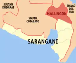 Map of Sarangani with Malungon highlighted | |
OpenStreetMap 
| |
.svg.png.webp) Malungon Location within the Philippines | |
| Coordinates: 6°16′N 125°17′E | |
| Country | |
| Region | Soccsksargen (Region XII) |
| Province | Sarangani |
| District | Lone District |
| Barangays | 31 (see Barangays) |
| Government | |
| • Type | Sangguniang Bayan |
| • Mayor | Maria Theresa D. Constantino |
| • Vice Mayor | Mariano S. Escalada, Jr. |
| • Representative | Rogelio D. Pacquiao |
| • Electorate | 72,319 voters (2019) |
| Area | |
| • Total | 750.92 km2 (289.93 sq mi) |
| Elevation | 233 m (764 ft) |
| Population | |
| • Total | 103,604 |
| • Density | 140/km2 (360/sq mi) |
| • Households | 24,508 |
| Economy | |
| • Income class | 1st municipal income class |
| • Poverty incidence | 48.31% (2015)[4] |
| • Revenue | ₱254,551,160.78 (2016) |
| Time zone | UTC+8 (PST) |
| ZIP code | 9503 |
| PSGC | |
| IDD : area code | +63 (0)83 |
| Climate type | tropical rainforest climate |
| Native languages | Cebuano Tboli Maguindanao Blaan Tagalog |
Malungon is a landlocked town at the north-eastern part of Sarangani. It is bounded on the west by Tupi, South Cotabato, on the north by the province of Davao del Sur, east by Malita, capital of the newly created province of Davao Occidental, on the south by Alabel (the provincial capital) and General Santos City, and on the south-west by Polomolok, South Cotabato.
Barangays
Malungon is politically subdivided into 31 barangays.
Climate
| Climate data for Malungon, Sarangani | |||||||||||||
|---|---|---|---|---|---|---|---|---|---|---|---|---|---|
| Month | Jan | Feb | Mar | Apr | May | Jun | Jul | Aug | Sep | Oct | Nov | Dec | Year |
| Average high °C (°F) | 30 (86) |
30 (86) |
31 (88) |
31 (88) |
30 (86) |
29 (84) |
29 (84) |
29 (84) |
30 (86) |
30 (86) |
30 (86) |
30 (86) |
30 (86) |
| Average low °C (°F) | 22 (72) |
22 (72) |
22 (72) |
23 (73) |
24 (75) |
24 (75) |
23 (73) |
23 (73) |
24 (75) |
24 (75) |
23 (73) |
23 (73) |
23 (73) |
| Average precipitation mm (inches) | 54 (2.1) |
41 (1.6) |
56 (2.2) |
81 (3.2) |
154 (6.1) |
212 (8.3) |
223 (8.8) |
218 (8.6) |
192 (7.6) |
184 (7.2) |
135 (5.3) |
73 (2.9) |
1,623 (63.9) |
| Average rainy days | 10.4 | 9.1 | 11.2 | 14.4 | 24.6 | 27.0 | 26.7 | 26.1 | 25.6 | 26.9 | 22.6 | 15.1 | 239.7 |
| Source: Meteoblue [6] | |||||||||||||
Demographics
| Year | Pop. | ±% p.a. |
|---|---|---|
| 1970 | 13,629 | — |
| 1975 | 30,060 | +17.19% |
| 1980 | 38,677 | +5.17% |
| 1990 | 57,982 | +4.13% |
| 1995 | 92,433 | +9.13% |
| 2000 | 93,232 | +0.18% |
| 2007 | 95,993 | +0.40% |
| 2010 | 95,044 | −0.36% |
| 2015 | 103,604 | +1.66% |
| Source: Philippine Statistics Authority [3] [7] [8][9] | ||
Economy
Malungon's economy is largely based on agriculture with a high level production of dried coconut meat. Animal husbandry is the second biggest income earner, notably cattle farming. Other agricultural products are coconuts, maize, sugarcane, bananas, pineapples, mangoes, pork, eggs, beef, and fish.
The economy has accelerated in the past decade driven by advances in global communication technology and the finishing of a modern highway that tremendously improved trade and transport.
References
- Municipality of Malungon | (DILG)
- "Province: Sarangani". PSGC Interactive. Quezon City, Philippines: Philippine Statistics Authority. Retrieved 12 November 2016.
- Census of Population (2015). "Region XII (Soccsksargen)". Total Population by Province, City, Municipality and Barangay. PSA. Retrieved 20 June 2016.
- "PSA releases the 2015 Municipal and City Level Poverty Estimates". Quezon City, Philippines. Retrieved 12 October 2019.
- http://www.kafyeblaan.com
- "Malungon: Average Temperatures and Rainfall". Meteoblue. Retrieved 15 May 2020.
- Census of Population and Housing (2010). "Region XII (Soccsksargen)". Total Population by Province, City, Municipality and Barangay. NSO. Retrieved 29 June 2016.
- Censuses of Population (1903–2007). "Region XII (Soccsksargen)". Table 1. Population Enumerated in Various Censuses by Province/Highly Urbanized City: 1903 to 2007. NSO.
- "Province of Sarangani". Municipality Population Data. Local Water Utilities Administration Research Division. Retrieved 17 December 2016.
External links
- Malungon Profile at PhilAtlas.com
- Malungon Municipal Profile at the Province of Sarangani Official Website
- Philippine Standard Geographic Code
- Philippine Census Information
- Local Governance Performance Management System
Places adjacent to Malungon | |
|---|---|