Mamurogawa
Mamurogawa (真室川町, Mamurogawa-machi) is a town located in Yamagata Prefecture, Japan. As of 29 February 2020, the town has an estimated population of 7,506 in 2678 households,[1] and a population density of 20 persons per km². The total area of the town is 374.29 square kilometres (145 sq mi).
Mamurogawa
真室川町 | |
|---|---|
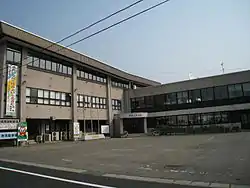 Mamurogawa Town Hall | |
 Flag | |
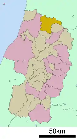 Location of Mamurogawa in Yamagata Prefecture | |
 Mamurogawa | |
| Coordinates: 38°51′28.4″N 140°15′8.3″E | |
| Country | Japan |
| Region | Tōhoku |
| Prefecture | Yamagata |
| District | Mogami |
| Area | |
| • Total | 374.29 km2 (144.51 sq mi) |
| Population (February 2020) | |
| • Total | 7,506 |
| • Density | 20/km2 (52/sq mi) |
| Time zone | UTC+9 (Japan Standard Time) |
| - Tree | Prunus mume |
| - Flower | Prunus mume |
| Phone number | 0233-62-2111 |
| Address | 127-7 Shincho, Mamurogawa-machi, Mogami-gun, Yamagata-ken 999-5301 |
| Website | Official website |
Geography
Mamurogawa is located in the extreme northern Yamagata Prefecture, bordering on Akita Prefecture to the north. The town is located in the Shinjō Valley, surrounding by low mountains on all sides, with the Ōu Mountains to the northeast. The area is known for its heavy snowfalls in winter.
Demographics
Per Japanese census data,[2] the population of Mamurogawa peaked in the 1950s, and is now considerably less than what it was a century ago.
| Year | Pop. | ±% |
|---|---|---|
| 1920 | 11,050 | — |
| 1930 | 12,499 | +13.1% |
| 1940 | 13,629 | +9.0% |
| 1950 | 17,020 | +24.9% |
| 1960 | 16,856 | −1.0% |
| 1970 | 13,976 | −17.1% |
| 1980 | 12,888 | −7.8% |
| 1990 | 12,230 | −5.1% |
| 2000 | 10,592 | −13.4% |
| 2010 | 9,165 | −13.5% |
Climate
Mamurogawa has a Humid continental climate (Köppen climate classification Cfa) with large seasonal temperature differences, with warm to hot (and often humid) summers and cold (sometimes severely cold) winters. Precipitation is significant throughout the year, but is heaviest from August to October. The average annual temperature in Mamurogawa is 10.4 °C. The average annual rainfall is 1872 mm with September as the wettest month. The temperatures are highest on average in August, at around 24.1 °C, and lowest in January, at around -2.0 °C.[3]
History
The area of present-day Mamurogawa was part of ancient Dewa Province and the location of Sakenobe Castle in the Sengoku period. After the start of the Meiji period, the area became part of Mogami District, Yamagata Prefecture. The village of Mamurogawa was established on April 1, 1889 with the establishment of the modern municipalities system. During World War II, an airbase for training pilots was established by the Imperial Japanese Army. The site is now a park, and part of the grounds of the local high school. Mamurogawa was elevated to town status on April 1, 1950. On August 1, 1954, it absorbed the neighboring villages of Araki and Nozoki.
Economy
The economy of Mamurogawa is based on agriculture and forestry.
Education
Mamurogawa has three public elementary schools and one public middle school operated by the town government and one public high school operated by the Yamagata Prefectural Board of Education.
Transportation
Highway
.png.webp) Tōhoku-Chūō Expressway – Mamurogawa interchange
Tōhoku-Chūō Expressway – Mamurogawa interchange National Route 13
 National Route 344
Local attractions
- Kabusan Prefectural Park
- Tokasaka Dam
Notes
External links
![]() Media related to Mamurogawa, Yamagata at Wikimedia Commons
Media related to Mamurogawa, Yamagata at Wikimedia Commons
- Official Website (in Japanese)
| Core city | ||
|---|---|---|
| Cities | ||
| Districts | ||
| Authority control |
|---|