Manali, Himachal Pradesh
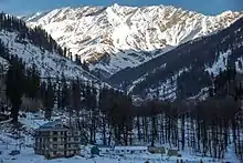
Manali is a resort town nestled in the mountains of the Indian state of Himachal Pradesh near the northern end of the Kullu Valley in the Beas River Valley. It is located in the Kullu district, about 270 km (168 mi) north of the state capital, Shimla, 309 km (192 miles) northeast of Chandigarh, and 544 km (338 miles) northeast of Delhi, the national capital. The small town, with a population of 8,096, is the beginning of an ancient trade route to Ladakh and from there over the Karakoram Pass on to Yarkand and Khotan in the Tarim Basin. It is a popular tourist destination and serves as the gateway to Lahaul and Spiti district as well as Leh.
Manali
Kulu | |
|---|---|
Town | |
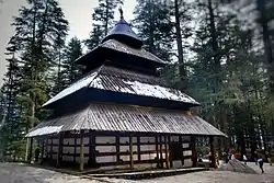 Hidimba Devi Temple in Manali | |
<mapframe>: The JSON content is not valid GeoJSON+simplestyle
| |
 Manali  Manali | |
| Coordinates: 32.27°N 77.17°E | |
| Country | India |
| State | Himachal Pradesh |
| District | Kullu |
| Elevation | 2,050 m (6,730 ft) |
| Population (2011) | |
| • Total | 8,096[1] |
| • Rank | 22 in HP |
| Languages | |
| • Official | Hindi |
| Time zone | UTC+5:30 (IST) |
| PIN | 175131 |
| Telephone code | +911902 |
| Vehicle registration | HP-58 |
History
Manali is named after the Sanatan Hindu lawgiver Manu. The name Manali is regarded as the derivative of 'Manu-Alaya' which means 'the abode of Manu'. Legend has it that sage Manu stepped off his ark in Manali to recreate human life after a great flood had deluged the world. Manali lies in the North of Kullu Valley. The valley is often referred to as the 'Valley of the Gods'. Old Manali village has an ancient temple dedicated to sage Manu.
The British introduced apple trees in the area. The first apple orchard was set up by the British near Patlikuhal, before this, no Apple trees grew in the area. To this day, apples— along with plum and pear— remain the best source of income for the majority of inhabitants. Both Rainbow and Brown Trout were also introduced into the rivers and streams of the area by the colonizers.
With the increase in disposable incomes and somewhat owing to the rise of disturbances in Kashmir in the late 1980s, Manali witnessed a surge in tourist traffic. This once quiet village was transformed into a bustling town with numerous homestays as well as the occasional boutique hotel. During the warmer summer months, cafes and restaurants can be seen doing brisk business.
Geography
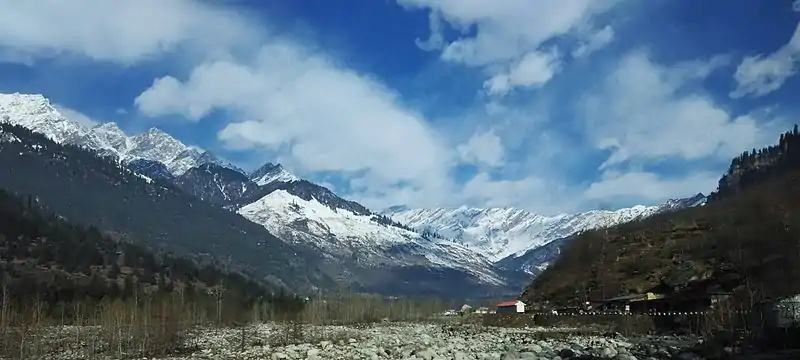
Manali is located at 32.2396 N, 77.1887 E, about 547 km (340 mi) north of New Delhi.
Demographics
Manali has grown from a trading village to a small town; as of the 2011 census of India, its population was 8,096. In 2001, Manali had an official population of 6,265. Males constituted 64% of the population and females 36%. Manali had an average literacy rate of 74%, higher than the national average of 59.5%; male literacy was 80%, and female literacy was 63.9%. 9.5% of the population was under six years of age.[2] During the summer months, there is a marked surge in the transients as many of them are employed in the hospitality businesses.
Climate
Manali features a subtropical highland climate (Cfb) with warm summers, relatively cold winters, and a high diurnal temperature variation. The temperatures range from −7 °C (19 °F) to 30 °C (86 °F) over the year with the hottest day crossing 30 °C (86 °F) and the coldest day going below −7 °C (19 °F). The average temperature during summer is between 10 °C (50 °F) to 30 °C (86 °F), and between −7 °C (19 °F) to 15 °C (59 °F) in the winter.
Monthly precipitation varies between 31 mm (1.2 in) in November and 217 mm (8.5 in) in July. On average, some 45 mm (1.8 in) of precipitation is received during winter and spring months, increasing to some 115 mm (4.5 in) in summer as the monsoon approaches. The average total annual precipitation is 1,363 mm (53.7 in). Manali experiences snowfall predominantly between December and the beginning of March.
| Climate data for Manali, Himachal Pradesh (1981–2010, extremes 1968–2011) | |||||||||||||
|---|---|---|---|---|---|---|---|---|---|---|---|---|---|
| Month | Jan | Feb | Mar | Apr | May | Jun | Jul | Aug | Sep | Oct | Nov | Dec | Year |
| Record high °C (°F) | 19.5 (67.1) |
23.5 (74.3) |
27.0 (80.6) |
30.0 (86.0) |
35.0 (95.0) |
33.2 (91.8) |
32.6 (90.7) |
30.6 (87.1) |
29.2 (84.6) |
30.0 (86.0) |
25.6 (78.1) |
21.5 (70.7) |
35.0 (95.0) |
| Average high °C (°F) | 10.8 (51.4) |
12.1 (53.8) |
16.7 (62.1) |
21.7 (71.1) |
24.9 (76.8) |
27.0 (80.6) |
26.9 (80.4) |
25.5 (77.9) |
24.7 (76.5) |
22.0 (71.6) |
17.7 (63.9) |
13.5 (56.3) |
20.2 (68.4) |
| Average low °C (°F) | −1.1 (30.0) |
0.2 (32.4) |
3.0 (37.4) |
6.4 (43.5) |
9.1 (48.4) |
12.8 (55.0) |
15.9 (60.6) |
16.0 (60.8) |
12.2 (54.0) |
6.1 (43.0) |
2.2 (36.0) |
0.2 (32.4) |
6.9 (44.4) |
| Record low °C (°F) | −11.6 (11.1) |
−11.0 (12.2) |
−6.0 (21.2) |
−1.0 (30.2) |
1.0 (33.8) |
4.4 (39.9) |
7.4 (45.3) |
7.0 (44.6) |
3.0 (37.4) |
−1.5 (29.3) |
−5.0 (23.0) |
−10.0 (14.0) |
−11.6 (11.1) |
| Average rainfall mm (inches) | 83.5 (3.29) |
110.4 (4.35) |
156.9 (6.18) |
84.7 (3.33) |
73.5 (2.89) |
73.9 (2.91) |
190.3 (7.49) |
192.1 (7.56) |
113.1 (4.45) |
35.9 (1.41) |
28.1 (1.11) |
55.0 (2.17) |
1,197.4 (47.14) |
| Average rainy days | 5.2 | 7.4 | 8.0 | 5.5 | 5.8 | 6.4 | 12.1 | 13.6 | 7.7 | 2.3 | 1.7 | 2.9 | 78.6 |
| Average relative humidity (%) (at 17:30 IST) | 61 | 61 | 53 | 56 | 61 | 63 | 74 | 76 | 75 | 69 | 61 | 62 | 64 |
| Source: India Meteorological Department[3][4] | |||||||||||||
Transport
Air
The nearest airport Bhuntar Airport (IATA code KUU) is at Bhuntar town, situated on NH21 about 50 km (31 mi) south of Manali and 10 km (6.2 mi) south of Kullu town. The airport is also known as Kullu-Manali airport and has more than a kilometre long runway. Air India has regular flights to the airport from New Delhi.
Helicopter taxi service
Pawan Hans, the Government charter agency, provides heli-taxi service connecting Shimla to Chandigarh, Kullu, and Dharamshala.[5]
Road
Manali can be reached from Delhi by national highway NH 1 up to Ambala and from there NH 22 to Chandigarh and from there by national highway NH21 that passes through Bilaspur, Sundernagar, Mandi and Kullu towns. The road distance from Chandigarh to Manali is 310 km (190 mi), and the total distance from Delhi to Manali is 570 km (350 mi). Bus services are available from HRTC (Himachal Road Transport Corporation), HPTDC (Himachal Tourism Development Corporation), and private operators.
Rail
There is no close railhead available close to Manali. The nearest broad gauge railheads are at Una 250 km (155 mi) away, Kiratpur Sahib 268 km (167 mi), Kalka (275 km (171 mi)), Chandigarh (310 km (193 mi)), and Pathankot (325 km (202 mi)). The nearest narrow gauge railhead is at Joginder Nagar (175 kilometres (109 mi)). The Kalka–Shimla Railway is a nostalgic narrow-gauge route culminating at the state capital of Shimla wherefrom one has to travel by road to Manali.
Environmental concerns
Manali has witnessed a flurry of activity related to hydroelectric power and tourism. Unplanned and rampant construction has led to severe depletion of forests and pollution of river bodies, along with garbage being disposed of on the side of the mountains. There has been a loss of habitat to various species of fauna, not limited to the Himalayan monal, incidentally the state bird of Himachal Pradesh.
Further reading
- Verma, V. 1996. Gadd of Dhauladhar: A Transhumant Tribe of the Himalayas. Indus Publishing Co., New Delhi.
- Handa, O. C. 1996. Buddhist Monasteries in Himachal Pradesh. ISBN 978-8185182032.
- Penelope Chetwode 1972, 1989 "Kulu: The End of the Habitable World" (ISBN 9788185113203) Time Books International
References
- "Manali (Kullu, Himachal Pradesh, India) - population statistics, map, and location". Retrieved 1 August 2014.
- "Census of India 2001: Data from the 2001 Census, including cities, villages and towns (Provisional)". Census Commission of India. Archived from the original on 16 June 2004. Retrieved 1 November 2008.
- "Station: Manali Climatological Table 1981–2010" (PDF). Climatological Normals 1981–2010. India Meteorological Department. January 2015. pp. 469–470. Archived from the original (PDF) on 5 February 2020. Retrieved 15 February 2020.
- "Extremes of Temperature & Rainfall for Indian Stations (Up to 2012)" (PDF). India Meteorological Department. December 2016. p. M69. Archived from the original (PDF) on 5 February 2020. Retrieved 15 February 2020.
- "Shimla-Chandigarh helicopter service now operating six days a week". Himachal Tourism Official Website. 19 March 2019. Retrieved 21 November 2019.
External links
| Wikimedia Commons has media related to Manali. |
Himachal Tourism Official Govt Website
| Wikivoyage has a travel guide for Manali. |