Manistee River
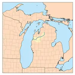
The Manistee River in the U.S. state of Michigan, runs 190 miles (310 km)[2] through the northwestern Lower Peninsula; it now passes through the contemporary villages of Sharon, Smithville, and Mesick, entering Lake Michigan at Manistee. It is considered, like the nearby Au Sable River, to be one of the best trout fisheries east of the Rockies.
| Manistee River | |
|---|---|
 | |
| Physical characteristics | |
| Source | |
| • location | Mancelona Township, Antrim County, Michigan |
| • coordinates | 44.93501°N 84.86837°W[1] |
| • elevation | 1,250 ft (380 m) |
| Mouth | |
• location | Lake Michigan |
• coordinates | 44.25°N 86.34453°W |
• elevation | 579 ft (176 m) |
| Length | 190 mi (310 km) |
| Basin size | 1,780 sq mi (4,600 km2) |
| Type | Recreational |
| Designated | March 3, 1992 |
The river rises in the sand hills in southeastern Antrim County, on the border with Otsego County, about 6 miles (10 km) southeast of the town of Alba. These deep glacial sands provide it with a remarkably stable flow of clean cold water year round, making it a popular river for fishing as well as canoeing. Over the course of its length, it drops in elevation from around 1,250 to 579 feet (381 to 176 m), with an average stream gradient of about 2.9 feet per mile (55 cm/km).[3]
History
The name "Manistee" is from an Ojibwe word whose derivation is uncertain.[4] However, it may be from ministigweyaa, "river with islands at its mouth".[5][6] The Ojibwe (Chippewa in the United States) and Ottawa peoples lived along the river, with the Ottawa having a reservation on the river from 1836. The federally recognized Little River Band of Ottawa Indians continues to occupy its reservation in Manistee County, as well as lands in Mason County.
Historically, the upper river was renowned for its outstanding grayling fishery, among the finest in the world. Catches in excess of 1000 fish per weekend outing were commonly reported up until the 1880s, when extensive logging in the area ruined the streams and habitat. Logging in the area commenced in earnest by European-American settlers between 1880 and 1910, with peak production occurring in the 1890s. Logging denuded habitat areas, with silt runoff and logging debris degrading the water quality of the river.
The river's relatively large size, stable flows, and dearth of cataracts or other difficult passages made it ideal for the transportation of lumber. During this period huge numbers of white pine logs, some as large as 6 feet (1.8 m) in diameter, were floated down the river to the port at Manistee and eventually on to the lumber markets of Grand Rapids, Milwaukee and Chicago. The wood was used to build the cities and towns of the Midwestern United States. Some of these logs became trapped at various points on the river, and can be seen today along the river bottom.
Environment
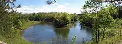
The Manistee River State Game Area is located upstream of Lake Manistee, and consists of areas of bayous and meandering marshlands located adjacent to the main river channel.[7] This state game area is managed by the Michigan Department of Natural Resources and contains a total area of 3,920 acres which overlay the Manistee River west of Manistee, Michigan. The adjacent hunting and fishing areas include Tatches Bayou, Claybanks Bayou, and Anderson Bayou. Duck hunting and northern pike fishing are popular activities within the managed marshland.
The Manistee River State Game Area encompasses nearly 4,000 acres of wetland, forest and grassland habitats. The Manistee Marsh, on the west end of the game area, includes the eastern shore of Manistee Lake and is bordered by the Manistee River. The marshland and adjacent forestland makes great habitat for wood ducks. Wood ducks nest in tree cavities and dine on acorns, seeds, berries and insects on the forest floor in addition to aquatic plant and insect foods.
Plenty of other wetland species call Manistee Marsh home. The marshlands provide important habitat for nesting and migrating ducks, geese, herons, terns and other wetland birds. The marshes are also home to muskrats, mink, frogs, turtles, snakes and many other wetland critters.
Work is under way to remove invasive species, including phragmites, in the marsh. Phragmites australis, also known as common reed, is a perennial wetland grass that can grow to 15 feet in height. Invasive phragmites creates tall, dense stands that degrade wetlands and coastal areas by crowding out native plants and animals, blocking shoreline views, and reducing access for swimming, fishing and hunting. The dry plant material from phragmites also can create fire hazards.
The Manistee Marsh restoration project is funded by a Great Lakes Restoration Initiative grant. This work will improve plant diversity in the marsh, and reducing the phragmites cover will allow managers to create what’s called a “hemi-marsh” – a 50/50 mix of vegetation and open water that is very attractive to waterfowl.[8]
These wetlands are open to hiking, canoeing, kayaking, wildlife photography, fishing and birding. Bring a lunch and make a day of exploring the wetlands of Manistee Marsh.
Activities
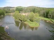
Today the river is used extensively for recreation, offering excellent conditions for canoeing, boating, and fishing. Having been restored since the ravages of the logging era, the river is again considered among the finest trout and salmon rivers in the country. Commercial navigation is possible in the lower stretches of the river below the Tippy Dam.
Bridges
| Route | Type | City | County | Location |
|---|---|---|---|---|
| Maple Street | City Street | Manistee | Manistee | |
| Cypress Street | City Street | |||
| M-55 | Michigan Highway | |||
| North High Bridge Road | County Road | |||
| County Road 115 | County Highway | Wexford | ||
| M-37 | Michigan Highway | |||
| US-131 | US Route | 44°29′3.18″N 85°24′22.82″W | ||
| West Farney Road | County Road | Missaukee | ||
| Coster Road Southwest | County Road | Kalkaska | ||
| County Road 66 | County Road | |||
| West Sharon Road | County Road | |||
| County Road 571 | County Road | |||
| Sunset Trail Southeast | County Road | |||
| M-72 | Michigan Highway | Crawford | 44°41′34.29″N 84°50′50.55″W |
References
- "Manistee River". Geographic Names Information System. United States Geological Survey.
- U.S. Geological Survey. National Hydrography Dataset high-resolution flowline data. The National Map Archived 2012-04-05 at WebCite, accessed November 21, 2011
- Rozich, Thomas (June 1998). Manistee River Assessment (PDF). Michigan Department of Natural Resources. Retrieved 2 July 2011.
- Bright, William (2004). Native American Place Names of the United States. Norman: Oklahoma University Press, pg. 265
- County place names Archived 2009-03-13 at the Wayback Machine
- "Manistee County, Michigan". 50-State Learning Resource Guide. Archived from the original on 2012-03-02. Retrieved 2009-04-07.
- "DNR - Manistee Marsh - Manistee River State Game Area". www.michigan.gov. Retrieved 2021-01-19.
- "Wetlands Month featured wetland: Manistee Marsh". Michigan Department of Natural Resources. Retrieved 2021-01-19.
| Authority control |
|
|---|