Antrim County, Michigan
Antrim County is a county located in the U.S. state of Michigan. As of the 2010 census, the population was 23,580.[2] The county seat is Bellaire.[3] The name is taken from County Antrim in Northern Ireland.
Antrim County | |
|---|---|
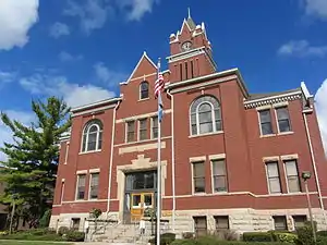 Antrim County Courthouse | |
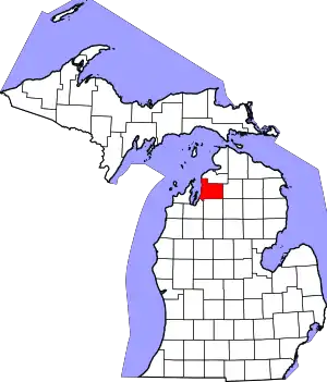 Location within the U.S. state of Michigan | |
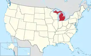 Michigan's location within the U.S. | |
| Coordinates: 45°01′N 85°11′W | |
| Country | |
| State | |
| Founded | 1840 (authorized) 1863 (organized)[1] |
| Named for | County Antrim |
| Seat | Bellaire |
| Largest village | Elk Rapids |
| Area | |
| • Total | 602 sq mi (1,560 km2) |
| • Land | 476 sq mi (1,230 km2) |
| • Water | 126 sq mi (330 km2) 21%% |
| Population | |
| • Estimate (2018) | 23,365 |
| • Density | 50/sq mi (20/km2) |
| Time zone | UTC−5 (Eastern) |
| • Summer (DST) | UTC−4 (EDT) |
| Congressional district | 1st |
YMCA Camp Hayo-Went-Ha, the oldest American summer camp that sits on its original site, occupies about one square mile on the shore of Torch Lake in Central Lake Township. Boys first attended Hayo-Went-Ha (variant of Hiawatha) in 1904.
History
The county was formed in 1840 as Meegisee County.[4] Meegisee (meaning "eagle"), was the name of a Chippewa chief who signed the 1821 Treaty of Chicago and the 1826 Treaty of Mississinewas.
It was renamed Antrim County in 1843,[4] one of the Irish or Scots Irish names given to five renamed Michigan counties at that time, supposedly in deference to the increasing number of settlers of Irish and Scots Irish heritage in Michigan at that time. In the text of the 1843 legislative act, the name was misspelled as "Antim".[1]
Separate county government was organized in 1863.[1][5] The county seat was originally located in Elk Rapids, but was moved to Bellaire in 1904 after 25 years of litigation.[6] In 1950 its population was 10,721.[7]
Geography
According to the U.S. Census Bureau, the county has a total area of 602 square miles (1,560 km2), of which 476 square miles (1,230 km2) is land and 126 square miles (330 km2) (21%) is water.[8]
The county is considered to be part of Northern Michigan. Glaciers shaped the area, creating a unique regional ecosystem. A large portion of the area is Grayling outwash plain, which consists of broad outwash plain including sandy ice-disintegration ridges; jack pine barrens, some white pine-red pine forest, and northern hardwood forest. Large lakes were created by glacial action.[9]
Transportation
Airports
- Antrim County Airport - county-owned public-use airport, northeast of Bellaire, for general aviation. One paved runway. No airline service.
Adjacent counties
- Charlevoix County – north
- Otsego County – east
- Crawford County − southeast
- Kalkaska County – south
- Grand Traverse County – southwest
- Leelanau County – west
Demographics
| Historical population | |||
|---|---|---|---|
| Census | Pop. | %± | |
| 1860 | 179 | — | |
| 1870 | 1,985 | 1,008.9% | |
| 1880 | 5,237 | 163.8% | |
| 1890 | 10,413 | 98.8% | |
| 1900 | 16,568 | 59.1% | |
| 1910 | 15,692 | −5.3% | |
| 1920 | 11,543 | −26.4% | |
| 1930 | 9,979 | −13.5% | |
| 1940 | 10,964 | 9.9% | |
| 1950 | 10,721 | −2.2% | |
| 1960 | 10,373 | −3.2% | |
| 1970 | 12,612 | 21.6% | |
| 1980 | 16,194 | 28.4% | |
| 1990 | 18,185 | 12.3% | |
| 2000 | 23,110 | 27.1% | |
| 2010 | 23,580 | 2.0% | |
| 2018 (est.) | 23,365 | [10] | −0.9% |
| US Decennial Census[11] 1790-1960[12] 1900-1990[13] 1990-2000[14] 2010-2018[2] | |||
As of the 2010 United States Census, there were 23,580 people, 9,890 households, and 6,925 families in the county. The population density was 49 people per square mile (19/km2). There were 17,824 housing units at an average density of 37 per square mile (45/km2). 96.8% of the population were White, 1.0% Native American, 0.2% Asian, 0.2% Black or African American, 0.4% of some other race and 1.4% of two or more races. 1.7% were Hispanic or Latino (of any race). 20.2% were of German, 13.4% English, 8.9% Irish, 6.9% French, French Canadian or Cajun, 6.9% Polish and 6.4% American ancestry.
There were 9,222 households, out of which 26% had children under the age of 18 living with them, 57.30% were married couples living together, 8.30% had a female householder with no husband present, and 30% were non-families. 25.3% of all households were made up of individuals, and 11.50% had someone living alone who was 65 years of age or older. The average household size was 2.36 and the average family size was 2.78.
The county population contained 21.10% under the age of 18, 6.30% from 19 to 24, 3.9% from 25 to 44, 31.1% from 45 to 64, and 22.2% who were 65 years of age or older. The median age was 47 years. For every 100 females there were 99.80 males.
Government
Antrim County has been reliably Republican since its organization. Since 1884 its voters have selected the Republican Party nominee in 94% (32 of 34) of the national elections through 2016.
| Year | Republican | Democratic | Third Parties |
|---|---|---|---|
| 2020 | 61.1% 9,748 | 37.4% 5,960 | 1.7% 264 |
| 2016 | 62.0% 8,469 | 32.6% 4,448 | 5.5% 750 |
| 2012 | 60.0% 7,917 | 38.7% 5,107 | 1.3% 171 |
| 2008 | 54.2% 7,506 | 43.9% 6,079 | 1.9% 267 |
| 2004 | 61.5% 8,379 | 37.2% 5,072 | 1.2% 168 |
| 2000 | 58.9% 6,780 | 37.6% 4,329 | 3.5% 398 |
| 1996 | 45.9% 4,630 | 41.9% 4,226 | 12.3% 1,242 |
| 1992 | 39.9% 3,984 | 34.3% 3,431 | 25.8% 2,576 |
| 1988 | 62.0% 5,231 | 37.4% 3,159 | 0.6% 54 |
| 1984 | 69.2% 5,726 | 30.3% 2,507 | 0.5% 44 |
| 1980 | 56.3% 4,706 | 34.8% 2,909 | 9.0% 749 |
| 1976 | 58.1% 4,369 | 40.3% 3,032 | 1.6% 117 |
| 1972 | 64.8% 4,068 | 31.8% 2,000 | 3.4% 213 |
| 1968 | 59.2% 3,002 | 33.4% 1,690 | 7.4% 376 |
| 1964 | 44.7% 2,172 | 55.2% 2,684 | 0.1% 7 |
| 1960 | 67.3% 3,398 | 32.6% 1,647 | 0.1% 7 |
| 1956 | 72.3% 3,623 | 27.5% 1,376 | 0.2% 9 |
| 1952 | 76.5% 3,533 | 22.7% 1,046 | 0.8% 39 |
| 1948 | 67.2% 2,588 | 29.3% 1,129 | 3.4% 132 |
| 1944 | 67.7% 2,626 | 31.1% 1,206 | 1.3% 49 |
| 1940 | 66.5% 3,027 | 32.9% 1,497 | 0.6% 29 |
| 1936 | 51.9% 2,391 | 44.1% 2,032 | 4.0% 185 |
| 1932 | 55.5% 2,308 | 40.6% 1,686 | 3.9% 164 |
| 1928 | 84.5% 2,756 | 14.8% 484 | 0.7% 23 |
| 1924 | 76.8% 2,246 | 12.7% 371 | 10.5% 308 |
| 1920 | 77.5% 2,260 | 17.8% 518 | 4.7% 137 |
| 1916 | 53.9% 1,336 | 37.6% 932 | 8.5% 210 |
| 1912 | 24.2% 603 | 18.1% 450 | 57.7% 1,437 |
| 1908 | 73.2% 2,020 | 20.8% 574 | 6.0% 165 |
| 1904 | 82.9% 2,608 | 13.9% 436 | 3.2% 102 |
| 1900 | 74.9% 2,575 | 21.2% 729 | 3.9% 134 |
| 1896 | 58.1% 1,886 | 37.8% 1,228 | 4.2% 135 |
| 1892 | 52.2% 1,140 | 37.3% 814 | 10.6% 231 |
| 1888 | 56.7% 1,305 | 38.3% 881 | 5.0% 114 |
| 1884 | 58.4% 1,066 | 39.5% 721 | 2.0% 37 |
Antrim County operates the County jail, maintains rural roads, operates the major local courts, records deeds, mortgages, and vital records, administers public health regulations, and participates with the state in the provision of social services. The county board of commissioners controls the budget and has limited authority to make laws or ordinances. In Michigan, most local government functions – police and fire, building and zoning, tax assessment, street maintenance etc. – are the responsibility of individual cities and townships.
Elected officials
- Prosecuting Attorney: James Rossiter
- Sheriff: Daniel S. Bean
- County Clerk: Sheryl Guy
- County Treasurer: Sherry A. Comben
- Register of Deeds: Patty Niepoth
- Drain Commissioner: Mark Stone
- County Surveyor: Scott Papineau
(information as of September 2018)[16]
Communities
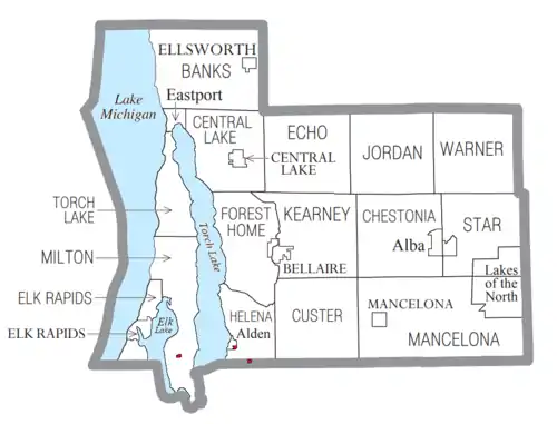
Villages
- Bellaire (county seat)
- Central Lake
- Elk Rapids
- Ellsworth
- Mancelona
Civil townships
Census-designated places
Unincorporated communities
Indian reservations
- Grand Traverse Indian Reservation, which has territories in five counties, occupies two small sections within Helena Township and one section in Milton Township.
Ghost towns
- Antrim City – former lumber company town on Lake Michigan
- Chestonia – in Jordan Township; former site of railroad depot and post office
See also
References
- "Bibliography on Antrim County". Clarke Historical Library, Central Michigan University. Retrieved January 19, 2013.
- "State & County QuickFacts". US Census Bureau. Archived from the original on July 6, 2011. Retrieved August 26, 2013.
- "Find a County". National Association of Counties. Retrieved June 7, 2011.
- Newberry Library. "Michigan: Individual County Chronologies". Atlas of County Historical Boundaries. Retrieved November 4, 2016.
- "History of Antrim County". Antrim County. Retrieved September 28, 2014.
- Historic marker in front of Bellaire courthouse
- Columbia Lippincott Gazetter, 1952, p. 80
- "2010 Census Gazetteer Files". US Census Bureau. August 22, 2012. Retrieved September 18, 2014.
- "NPWRC: Regional Landscape". usgs.gov.
- "Population and Housing Unit Estimates". Retrieved May 17, 2019.
- "US Decennial Census". US Census Bureau. Retrieved September 18, 2014.
- "Historical Census Browser". University of Virginia Library. Retrieved September 18, 2014.
- "Population of Counties by Decennial Census: 1900 to 1990". US Census Bureau. Retrieved September 18, 2014.
- "Census 2000 PHC-T-4. Ranking Tables for Counties: 1990 and 2000" (PDF). US Census Bureau. Retrieved September 18, 2014.
- US Election Atlas
- Antrim County website - Directory
External links
Places adjacent to Antrim County, Michigan | ||||||||||
|---|---|---|---|---|---|---|---|---|---|---|
| ||||||||||
Municipalities and communities of Antrim County, Michigan, United States | ||
|---|---|---|
| Villages | Map of Michigan highlighting Antrim County.svg | |
| Civil townships | ||
| CDPs | ||
| Other unincorporated communities | ||
| Indian reservation | ||
| Footnotes | ‡This populated place also has portions in an adjacent county or counties | |
| ||
| Central cities | |
|---|---|
| Counties | |
| Geography | |
| Transportation | |
| Economy | |
| Authority control |
|---|