Margaret, Alabama
Margaret is a city in St. Clair County, Alabama, United States. At the 2000 census the population was 1,169. As of the 2010 census, the population is 4,428, an increase of 278.8%. Margaret incorporated in 1960[3] and became a city in October 2011.
Margaret, Alabama | |
|---|---|
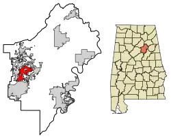 Location of Margaret in St. Clair County, Alabama. | |
| Coordinates: 33°40′33″N 86°28′4″W | |
| Country | United States |
| State | Alabama |
| County | St. Clair |
| Area | |
| • Total | 9.84 sq mi (25.48 km2) |
| • Land | 9.82 sq mi (25.44 km2) |
| • Water | 0.01 sq mi (0.04 km2) |
| Elevation | 699 ft (213 m) |
| Population (2010) | |
| • Total | 4,428 |
| • Estimate (2019)[2] | 5,137 |
| • Density | 523.01/sq mi (201.94/km2) |
| Time zone | UTC-6 (Central (CST)) |
| • Summer (DST) | UTC-5 (CDT) |
| ZIP code | 35120 |
| Area code(s) | 205, 659 |
| FIPS code | 01-46696 |
| GNIS feature ID | 0164749 |
Geography
Margaret is located at 33°40′33″N 86°28′4″W (33.675957, -86.467641).[4]
According to the U.S. Census Bureau, the city has a total area of 9.3 square miles (24 km2), of which 9.3 square miles (24 km2) is land and 0.04 square miles (0.10 km2) (0.21%) is water.
Demographics
| Historical population | |||
|---|---|---|---|
| Census | Pop. | %± | |
| 1950 | 1,144 | — | |
| 1960 | 715 | −37.5% | |
| 1970 | 685 | −4.2% | |
| 1980 | 757 | 10.5% | |
| 1990 | 616 | −18.6% | |
| 2000 | 1,169 | 89.8% | |
| 2010 | 4,428 | 278.8% | |
| 2019 (est.) | 5,137 | [2] | 16.0% |
| U.S. Decennial Census[5] 2013 Estimate[6] | |||
At the 2000 census there were 1,169 people in 401 households, including 326 families, in the city. The population density was 125.8 people per square mile (48.6/km2). There were 457 housing units at an average density of 49.2 per square mile (19.0/km2). The racial makeup of the town was 65.18% White, 32.59% Black or African American, 0.34% Asian, 0.09% from other races, and 1.80% from two or more races.[7] Of the 401 households 41.9% had children under the age of 18 living with them, 60.8% were married couples living together, 16.5% had a female householder with no husband present, and 18.7% were non-families. 16.7% of households were one person and 4.5% were one person aged 65 or older. The average household size was 2.92 and the average family size was 3.26.
The age distribution was 31.7% under the age of 18, 8.3% from 18 to 24, 30.9% from 25 to 44, 22.3% from 45 to 64, and 6.8% 65 or older. The median age was 31 years. For every 100 females, there were 92.6 males. For every 100 females age 18 and over, there were 90.0 males.
The median household income was $30,147 and the median family income was $32,019. Males had a median income of $28,798 versus $16,855 for females. The per capita income for the town was $13,764. About 14.0% of families and 15.9% of the population were below the poverty line, including 16.9% of those under age 18 and 13.1% of those age 65 or over.
2010 census
At the 2010 census there were 4,428 people in 1,543 households, including 1,252 families, in the city. The population density was 476.1 people per square mile (183.7/km2). There were 1,698 housing units at an average density of 182.6 per square mile (70.5/km2). The racial makeup of the town was 77.3% White, 19.3% Black or African American, 0.8% Asian, 0.8% from other races, and 1.5% from two or more races.[8] Of the 1,543 households 44.3% had children under the age of 18 living with them, 66.8% were married couples living together, 9.7% had a female householder with no husband present, and 18.9% were non-families. 15.6% of households were one person and 2.3% were one person aged 65 or older. The average household size was 2.87 and the average family size was 3.19.
The age distribution was 29.9% under the age of 18, 6.7% from 18 to 24, 38.5% from 25 to 44, 19.9% from 45 to 64, and 5.0% 65 or older. The median age was 31 years. For every 100 females, there were 99.8 males. For every 100 females age 18 and over, there were 98.3 males.
The median household income was $52,111 and the median family income was $52,463. Males had a median income of $41,941 versus $34,242 for females. The per capita income for the town was $19,984. About 3.3% of families and 6.2% of the population were below the poverty line, including 1.6% of those under age 18 and 14.0% of those age 65 or over.
Notable people
- Major General Oliver W. Dillard, US Army Retired, became the Army's fifth Black general officer in 1972. He was elected into the Army's Military Intelligence Hall of Fame in 2012, and the Alabama Military Hall of Honor in 2013.
- Sammy Price, former running back for the Miami Dolphins
References
- "2019 U.S. Gazetteer Files". United States Census Bureau. Retrieved June 29, 2020.
- "Population and Housing Unit Estimates". United States Census Bureau. May 24, 2020. Retrieved May 27, 2020.
- http://www.encyclopediaofalabama.org/article/h-3505
- "US Gazetteer files: 2010, 2000, and 1990". United States Census Bureau. 2011-02-12. Retrieved 2011-04-23.
- "U.S. Decennial Census". Census.gov. Retrieved June 6, 2013.
- "Annual Estimates of the Resident Population: April 1, 2010 to July 1, 2013". Retrieved June 3, 2014.
- "U.S. Census website". United States Census Bureau. Retrieved 2008-01-31.
- "U.S. Census website". United States Census Bureau. Retrieved 2015-08-09.
Municipalities and communities of St. Clair County, Alabama, United States | ||
|---|---|---|
| Cities | 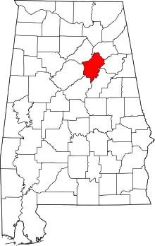 Map of Alabama highlighting St. Clair County | |
| Towns | ||
| Unincorporated communities | ||
| Former towns | ||
| Footnotes | ‡This populated place also has portions in an adjacent county or counties | |
| ||
| Authority control |
|---|