Matsushima, Miyagi
Matsushima (松島町, Matsushima-machi) is a town in Miyagi Prefecture, Japan. As of 1 June 2019, the town had an estimated population of 13,804 in 5663 households,[1] and a population density of 260 persons per km². The total area of the town is 53.56 square kilometres (20.68 sq mi). It is most famous as the location of Matsushima Bay, one of the Three Views of Japan, and is also the site of the Zuigan-ji, Entsū-in and Kanrantei.
Matsushima
松島町 | |
|---|---|
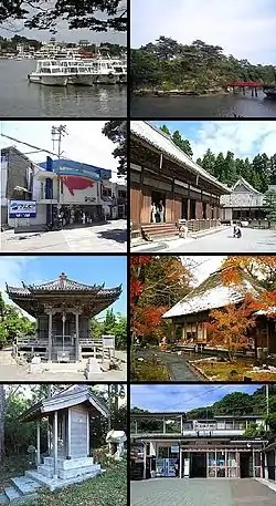
 Top left: Matsushima Port, top right: Togetsukyō Bridge to Oshima Island, 2nd left: Matsushima Marinpia Aquarium (closed), 2nd right: Zuiganji Temple, 3rd left: Godaidō, 3rd right: Entsuin Temple, bottom left: Atago Shrine, bottom right: Matsushima Kaigan Train Station | |
 Flag  Seal | |
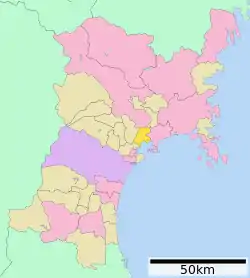
 Location of Matsushima in Miyagi Prefecture | |
 Matsushima | |
| Coordinates: 38°22′48.6″N 141°04′2.4″E | |
| Country | Japan |
| Region | Tōhoku |
| Prefecture | Miyagi |
| District | Miyagi |
| Government | |
| • Mayor | Kouichi Sakurai (since October 2015) |
| Area | |
| • Total | 53.56 km2 (20.68 sq mi) |
| Population (June 1, 2020) | |
| • Total | 13,804 |
| • Density | 260/km2 (670/sq mi) |
| Time zone | UTC+9 (Japan Standard Time) |
| - Tree | Pine |
| - Flower | Sekikoku |
| Phone number | 022-354-5701 |
| Address | 10 Takagi-aza-chō, Matsushima-machi, Miyagi-gun, Miyagi-ken 981-0215 |
| Website | Official website |

Geography
Matsushima is located in east-central Miyagi Prefecture, with Matsushima Bay to the east. The town’s highest point is Mount Danyama, with a height of 178 meters.
Climate
Matsushima has a humid climate (Köppen climate classification Cfa) characterized by mild summers and cold winters. The average annual temperature in Higashi-Matsushima is 12.0 °C. The average annual rainfall is 1207 mm with September as the wettest month. The temperatures are highest on average in August, at around 24.5 °C, and lowest in January, at around 0.6 °C.[2]
Demographics
Per Japanese census data,[3] the population of Matsushima has been relatively stable over the past 70 years.
| Year | Pop. | ±% |
|---|---|---|
| 1920 | 7,644 | — |
| 1930 | 9,155 | +19.8% |
| 1940 | 10,064 | +9.9% |
| 1950 | 15,333 | +52.4% |
| 1960 | 15,045 | −1.9% |
| 1970 | 16,004 | +6.4% |
| 1980 | 17,246 | +7.8% |
| 1990 | 17,431 | +1.1% |
| 2000 | 17,059 | −2.1% |
| 2010 | 15,085 | −11.6% |
History
The area of present-day Matsushima was part of ancient Mutsu Province and has been settled since at least the Jōmon period. The Daigigakoi Shell Mound is one of the largest shell middens to have been discovered in Japan. With the establishment of Tagajō in the Nara period, Matsushima was part of the Yamato colonization area in the region. The Buddhist temple of Zuigan-ji comes to have been founded in 828 AD. During the Sengoku period, the area was contested by samurai clans before it came under the control of the Date clan of Sendai Domain during the Edo period, under the Tokugawa shogunate.
The village of Matsushima within Miyagi District, Miyagi was established on June 1, 1889 with the post-Meiji restoration establishment of the modern municipalities system. It was raised to town status on December 16, 1963.
Government
Matsushima has a mayor-council form of government with a directly elected mayor and a unicameral town council of 14 members. Matsushima, as part of Miyagi District contributes one seat to the Miyagi Prefectural legislature. In terms of national politics, the town is part of Miyagi 5th district of the lower house of the Diet of Japan.
Economy
The economy of Matsushima is largely based on tourism, farming, and commercial fishing, primarily the cultivation of oysters in Matsushima Bay.
Education
Matsushima has three public elementary schools and one public middle school operated by the town government and one public high school operated by the Miyagii Prefectural Board of Education.
Transportation
Railway
![]() East Japan Railway Company (JR East) - Tōhoku Main Line
East Japan Railway Company (JR East) - Tōhoku Main Line
![]() East Japan Railway Company (JR East) - Senseki Line
East Japan Railway Company (JR East) - Senseki Line
Highway
.png.webp) Sanriku Expressway (Matsushima-Ōsato IC — Matsushima-Kita IC)
Sanriku Expressway (Matsushima-Ōsato IC — Matsushima-Kita IC) National Route 45
 National Route 346
Seaports
- Port of Matsushima - Matsushima sightseeing boats
Local attractions
- Matsushima, one of the Three Views of Japan
- Zuigan-ji, founded 828 AD
- Entsū-in
- Nishinohama Shell Mound, a National Historic Site [4]
External relations
International sister cities
 France – Isle of Pines, New Caledonia,[5] since September 4, 1980
Japanese sister cities
- August 1, 1987: Kisakata, Akita
- October 16, 1988: Kamiamakusa, Kumamoto (formerly known as Matsushima)
Noted people from Matsushima
- Jun Senoue, musician
References
- Matsushima Town official statistics(in Japanese)
- Matsushima climate data
- Matsushima population statistics
- "西の浜貝塚". Cultural Heritage Online (in Japanese). Agency for Cultural Affairs. Retrieved 25 December 2016.
- "International Exchange". List of Affiliation Partners within Prefectures. Council of Local Authorities for International Relations (CLAIR). Archived from the original on 22 December 2015. Retrieved 21 November 2015.
External links
| Wikimedia Commons has media related to Matsushima, Miyagi. |
- Official Website (in Japanese)
