Minamisanriku
Minamisanriku (南三陸町, Minamisanriku-chō) is a town in Miyagi Prefecture, Japan. As of 1 May 2020, it had an estimated population of 12,516, and a population density of 77 persons per km² in 4504 households.[1] The total area of the town is 163.40 square kilometres (63.09 sq mi). It is a resort town on a coastline of wooded islands and mountainous inlets; large sections of which suffered from damage due to the 2011 Tōhoku earthquake and tsunami.[2]
Minamisanriku
南三陸町 | |
|---|---|
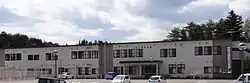 Minamisanriku Town Hall, May 2013 | |
 Flag  Seal | |
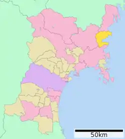 Location of Minamisanriku in Miyagi Prefecture | |
 Minamisanriku | |
| Coordinates: 38°40′45.6″N 141°27′38.8″E | |
| Country | Japan |
| Region | Tōhoku |
| Prefecture | Miyagi |
| District | Motoyoshi |
| Area | |
| • Total | 163.40 km2 (63.09 sq mi) |
| Population (May 1, 2020) | |
| • Total | 12,516 |
| • Density | 77/km2 (200/sq mi) |
| Time zone | UTC+09:00 (Japan Standard Time) |
| - Tree | Persera thunbergii |
| - Flower | Azalea |
| - Bird | Golden eagle |
| - Fish | Common octopus |
| - Color | sky blue |
| Address | 77 Shioiri, Shizugawa, Minamisanriku-cho, Motoyoshi-gun Miyagi-ken 986-0792 |
| Website | Official website |
Geography
Minamisanriku is in the far northeastern corner of Miyagi Prefecture. Its coastline is part of the Sanriku Fukkō National Park, which stretches north to Aomori Prefecture. The town is bordered to the north, west, and south by the Kitakami Mountains. About 70% of the area of the town is forested.[3]
Climate
Minamisanriku has a humid climate (Köppen climate classification Cfa) characterized by warm humid summers and cold winters. The average annual temperature in Mutsu is 11.1 °C. The average annual rainfall is 1217 mm with September as the wettest month. The temperatures are highest on average in August, at around 23.7 °C, and lowest in January, at around -0.2 °C.[4]
Demographics
Per Japanese census data,[5] the population of Minamisanriku peaked in the 1950s and has declined steadily over the past 70 years.
| Year | Pop. | ±% |
|---|---|---|
| 1920 | 17,054 | — |
| 1930 | 18,410 | +8.0% |
| 1940 | 19,496 | +5.9% |
| 1950 | 25,168 | +29.1% |
| 1960 | 24,852 | −1.3% |
| 1970 | 22,943 | −7.7% |
| 1980 | 22,243 | −3.1% |
| 1990 | 21,401 | −3.8% |
| 2000 | 19,860 | −7.2% |
| 2010 | 17,429 | −12.2% |
History
The area of present-day Minamisanriku was part of ancient Mutsu Province and came under the control of the Date clan of Sendai Domain during the Edo period, under the Tokugawa shogunate. The area has suffered from the effects of tsunami since ancient times, including the 869 Sanriku earthquake, and more recently during the 1896 Sanriku earthquake and the 1933 Sanriku earthquake. The 1896 earthquake resulted in the highest tsunami wave ever recorded in Japan at 38.2 metres (125.3 ft), until it was surpassed by a 40.4 metres (132.5 ft) wave at Miyako in the 2011 Tōhoku earthquake and tsunami.[6]
The villages of Shizukugawa and Utatsu were established on June 1, 1889 with the establishment of the modern municipalities system. Shizukugawa was elevated to town status on October 31, 1895 and Utatsu on April 1, 1959. The town was formed through a merger on October 1, 2005, when the towns of Shizugawa and Utatsu, both from Motoyoshi District, merged to form the new town of Minamisanriku.
The 1960 Valdivia earthquake triggered a tsunami that crossed the Pacific Ocean and struck the town of Shizugawa with a height of up to 2.8 metres (9.2 ft),[7] causing extensive damage.[8] As a result, two-story-high harbor walls were built by 1963, and residents held tsunami drills each year on the anniversary. To mark the 30th anniversary of the disaster in 1990, a bilingual Spanish-Japanese plaque was installed, with a message from President Patricio Aylwin of Chile, accompanied by a replica moai statue.[9]
The harbor walls proved ineffective in the 2011 tsunami, which washed over four-story buildings.[10]
The 2010 Chile earthquake caused a 1.3-metre (4.3 ft) tsunami in Minamisanriku.[11]
2011 earthquake and tsunami disaster
| Wikinews has related news: |
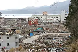
Immediate aftermath accounts suggested 95 percent of the town was destroyed by the 2011 Japanese tsunami that followed the 2011 Tōhoku earthquake. Only the tallest buildings remained, and roughly half the population was unaccounted for during the days following the disaster;[12][13][14][15] only 9,700 people were confirmed alive and evacuated in the first week.[16] In late June 2011, a total of 1,206 were counted as dead or missing, according to the Kahoku Shinpou.
The town had two evacuation centers where residents could go in the event of a tsunami, one on the southern headland overlooking the town, the other back from the center of the town. Although both were 20 meters above sea level, the tsunami inundated them and washed people away.[17] At least 31 of the town's 80 designated evacuation sites were inundated by the tsunami.[18] The average height of the tsunami in Minamisanriku was around 45 feet (14 m) above the sea-level, with the highest watermark recorded at 67.3 feet (20.5 m) just southwest of the city center.[19]
According to an English teacher at the high school on a hill above the tsunami, "The entire town was simply swept away. It just no longer exists. There were around 7,000 of us on the hill that day. Perhaps a few thousand at the school on the hill opposite. But there are 17,000 in the town. All the others have gone." Since the schools were all on high ground, many children were orphaned.[20] Survivors wrote "SOS" in white lettering,[21] in the playing field of Shizugawa High School.[22]
When the earthquake struck, the mayor, Jin Sato (佐藤仁), was talking at the town assembly about the much smaller tsunami caused by the March 9 foreshock of the March 11 earthquake.[23] The three-story building of the town's Crisis Management Department (防災対策庁舎, Bōsai Taisaku Chōsha) which Sato escaped to was submerged by the tsunami. Out of the 130 people who worked at the town hall, Sato was one of 53 who reached the roof and one of 10 who survived. He returned to government affairs, founding the headquarters for disaster control at the Bayside Arena in Miyagi on March 13, 2011.[23]
Shizugawa Hospital was one of the few major buildings that survived the tsunami. It was partly inundated, and 74 out of 109 patients died. Close to 200 people were rescued from the roof.[24]
Miki Endo, a 25-year-old employed by the town's Crisis Management Department to voice disaster advisories and warnings, was hailed in the Japanese news media as a heroine for sacrificing her life by continuing to broadcast warnings and alerts over the community loudspeaker system, in the Crisis Management Department's building, as the tsunami overwhelmed it. She was credited with saving many lives. The three-story headquarters of the department remained standing but was completely gutted, with only a red-colored steel skeleton remaining. In the aftermath of the disaster, Endo was missing and was later confirmed to have died.[25] Photos show the roof of the building completely submerged at the height of the inundation, with some people clinging to the rooftop antenna.[26][27]
International response
The town is the site of the first field hospital established by an outside nation offering assistance following the disaster. An initial team of five doctors from Israel set up a surgery in preparation for a larger team once needs were assessed.[28] A 53-member delegation of medical personnel from the Home Front Command and the IDF's Medical Corps opened a field hospital near Minamisanriku on March 29. The clinic included surgical, pediatrics and maternity wards, and an intensive care unit, pharmacy and laboratory along with 62 tons of medical supplies. The clinic was active in treating patients immediately upon opening.[29][30]
On 23 April 2011, the Prime Minister of Australia, Julia Gillard, visited Minamisanriku.[31]
Economy
Minamisanriku relies heavily on tourism and commercial fishing as mainstays of the local economy.
Education
Minamisanriku has five public elementary schools and two public middle schools operated by the town government and one public high school operated by the Miyagi Prefectural Board of Education.
Transportation
Railway
![]() East Japan Railway Company (JR East) - Kesennuma Line (Suspended indefinitely and replace by a BRT service)
East Japan Railway Company (JR East) - Kesennuma Line (Suspended indefinitely and replace by a BRT service)
Local attractions
- Mount Tatsugane
- Tubakishima (National Natural Monument)
- Daio-ji, Buddhist temple
Sister/friendship cities
 Besano, Lombardy, Italy,[32] since November 7, 1999
 Shōnai, Yamagata, Japan, since October 13, 1999
References
- Minamisanriku official statistics(in Japanese)
- Inside Minamisanriku Channel 4 News, 13 March 2011
- 詳細データ 宮城県南三陸町. 市町村の姿 グラフと統計でみる農林水産業 (in Japanese). Ministry of Agriculture, Forestry and Fisheries. 2016. Retrieved 13 April 2017.
- Minamisanriku climate data
- Minamisanriku population statistics
- Ryall, Julian (18 July 2011). "Japanese tsunami stood at 132.5ft". The Telegraph.
- flickr.com user ataq411. "Shizugawa Hospital, Minamisanriku-cho, Miyagi" (photo).
legend on marker in photo reads: 昭和35年5月24日 チリ地震津波水位 2.8m
- かつての宮城県志津川町(現・南三陸町) 津波への取り組み(1990年) (video). YouTube.com (in Japanese). Retrieved 2011-04-26. (video shows damage from 1960 tsunami)
- "南三陸町 Minamisanrikucho #5" (video). YouTube.com. Retrieved 2011-04-23.
- Todd Pitman. "Japan tsunami: Nothing to do but run". Associated Press. Retrieved 2011-04-23.
- "宮城・南三陸町で130cmの津波観測 漁港で冠水も(10/02/28)" (video). YouTube.com (in Japanese). Retrieved 2011-04-24.
- "9,500 still unaccounted in Minamisanriku of Japan's Miyagi Prefecture: Kyodo". Xinhua News Agency. Retrieved 2011-03-12.
- Kyung Lah, CNN (March 12, 2011). "Rescuers scramble to save lives as aftershocks jolt Japan". CNN.com. Retrieved 2011-03-12.
- 9,500 People Reported Missing in Small Town Following Japan Quake
- Horiuchi, Junko, (Kyodo News) "Evacuees persevere, eye future", Japan Times, 29 March 2011, p. 3.
- (Japanese)
- Natures fury leaves a silt-covered graveyard The Age, 16 March 2011
- Kyodo News, "Tsunami hit more than 100 designated evacuation sites", Japan Times, 14 April 2011, p. 1.
- "Detailed Analysis of the 2011 Japan Tsunami – Video Footage, Wave Heights and Damage Imagery". Extreme Planet. 4 February 2014.
- Minamisanriku: Japan's tsunami-hit ground zero Channel 4 News, 14 March 2011
- Flock, Elizabeth (March 13, 2011). "Japan tsunami: Minamisanriku, a fishing port that vanished". The Washington Post. Retrieved 18 March 2011.
- Zenrin Co. Ltd. (2011). "Google Maps". Google Maps. Retrieved 18 March 2011.
- 安否不明の町長生還 骨組みだけの庁舎で一夜 宮城・南三陸 (in Japanese). Kahoku Shimpo. March 14, 2011. Archived from the original on March 16, 2011. Retrieved March 15, 2011.
- Carswell, Andrew (March 14, 2011). "Minami Sanriku - the town that disappeared in the Japan earthquake". The Daily Telegraph. Retrieved 16 March 2011.
- Jiji Press, "Saitama to teach about Miyagi's tsunami 'angel'", Japan Times, 30 January 2012, p. 2.
- "Miki Endo, missing heroine of Minamisanriku" (video). NHK World. Retrieved 2011-04-23.
- [画像]宮城県南三陸町の防災対策庁舎の人を押し流す津波+南三陸町津波動画 (in Japanese). Retrieved 2011-04-23.
- "Israel first to set up field hospital in Japan", The Jerusalem Post, 21 March 2011, retrieved 2011-03-21
- Katz, Yakov (29 March 2011). "IDF field hospital officially open doors to Japanese". The Jerusalem Post. Retrieved 2011-03-30.
- "IDF medical delegation to Japan treats homeless baby". The Jerusalem Post. 30 March 2011. Retrieved 2011-03-30.
- "Gillard tours tsunami-devastated Minami Sanriku". The Sydney Morning Herald. 23 April 2011. Retrieved 6 August 2018.
- "International Exchange". List of Affiliation Partners within Prefectures. Council of Local Authorities for International Relations (CLAIR). Archived from the original on 22 December 2015. Retrieved 21 November 2015.
External links
| Wikimedia Commons has media related to Minamisanriku, Miyagi. |
- Official Website (in Japanese)
| Sendai |
| ||
|---|---|---|---|
| Cities | |||
| Districts | |||
| Geology | |||||||||||||||
|---|---|---|---|---|---|---|---|---|---|---|---|---|---|---|---|
| Affected areas |
| ||||||||||||||
| Affected infrastructure |
| ||||||||||||||
| Nuclear Accidents and Incidents |
| ||||||||||||||
| Foreshocks, Aftershocks |
| ||||||||||||||
| People | |||||||||||||||
| Relief and Recovery |
| ||||||||||||||
| Media |
| ||||||||||||||
| Other | |||||||||||||||
| Authority control |
|---|