Maud, Aberdeenshire
Maud (Scottish Gaelic: Am Mòd) is a village in the Buchan area of the Scottish county of Aberdeenshire, with a population of 780 (2006 estimate).[1] Located 13 miles (21 km) west of Peterhead on the South Ugie Water,[2] Maud rose to prosperity in the nineteenth century as a railway junction of the Formartine and Buchan Railway that ran through Maud to Fraserburgh and Peterhead, but has always been the meeting place of six roads. It has had a variety of names:
- Bank of Behitch
- Brucklay
- New Maud,
Maud
| |
|---|---|
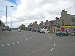 Maud village centre | |
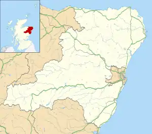 Maud Location within Aberdeenshire | |
| Population | 780 (2006) |
| OS grid reference | NJ925479 |
| Council area | |
| Lieutenancy area |
|
| Country | Scotland |
| Sovereign state | United Kingdom |
| Post town | PETERHEAD |
| Postcode district | AB42 |
| Police | Scotland |
| Fire | Scottish |
| Ambulance | Scottish |
| UK Parliament | |
| Scottish Parliament | |
the 'New' having since fallen out of use, leading to the village's current name.
The Village
Maud features an old railway station,[3] which closed to passengers in 1965. When the railway was active, Maud was where the railway line from Aberdeen split before heading to Fraserburgh and Peterhead. Walks can be taken along the old railway lines which now form part of the Formartine and Buchan Way; the railway tracks were removed following the ending of freight trains in 1979. There was a mart or livestock market until recently, selling local livestock. There is also a hospital for the elderly, which was formerly a poorhouse that opened in about 1868.
A modern complex in the centre of the village houses a cafe, community centre, gym and other facilities; the old town hall, a few minutes walk from the new complex, is also still in regular use by community groups. The village also has a small parade of shops.
The hamlet of Kirkhill Pendicle to the south of Maud has a weather station which features prominently in Met Office weather maps for Aberdeenshire.
History
The local area to the immediate south is rich with prehistory and historical features. There are found a number of prehistoric monuments including Catto Long Barrow,[4] Silver Cairn and numerous tumuli. In that same vicinity of the Laeca Burn watershed is the point d'appui of historic battles between invading Danes and indigenous Picts.
In the era of the railway, the New Maud junction station was situated 298 feet (91 metres) above sea level, with the vicinity rail line being noted for several embankments and shallow rock cuts.[5]
Notable people
- Prof Edward Burns Ross FRSE (1881–1947), mathematician born and raised in Maud
- Jack Webster (1931–2020), journalist, author & broadcaster born and raised in Maud.[6][7]
Line notes
- General Register Office for Scotland, 2006 population estimate Archived 2009-03-03 at the Wayback Machine, accessed 12 October 2009
- Maud Railway Station Museum
- C. Michael Hogan (2008) Catto Long Barrow fieldnotes, The Modern Antiquarian
- Alexander Smith (1875) A new history of Aberdeenshire
- Jack Webster's author page at Birlinn
- "Jack Webster obituary". Scotsman newspaper. Retrieved 16 April 2020.
External links
![]() Media related to Maud, Aberdeenshire at Wikimedia Commons
Media related to Maud, Aberdeenshire at Wikimedia Commons
Settlements and places of interest in Buchan, Aberdeenshire | ||
|---|---|---|
| Primary settlements |  | |
| Other settlements | ||
| Places of interest | ||
Areas and primary settlements in Aberdeenshire (see also: Aberdeen City) | ||
|---|---|---|
| in Banff and Buchan |  | |
| in Buchan | ||
| in Formartine | ||
| in Garioch | ||
| in Kincardine and Mearns | ||
| in Marr | ||