McAllister, Wisconsin
McAllister is an unincorporated community located in the town of Wagner, Marinette County, Wisconsin, United States.[1]
McAllister, Wisconsin | |
|---|---|
 McAllister, Wisconsin  McAllister, Wisconsin | |
| Coordinates: 45°19′38″N 87°43′16″W | |
| Country | |
| State | |
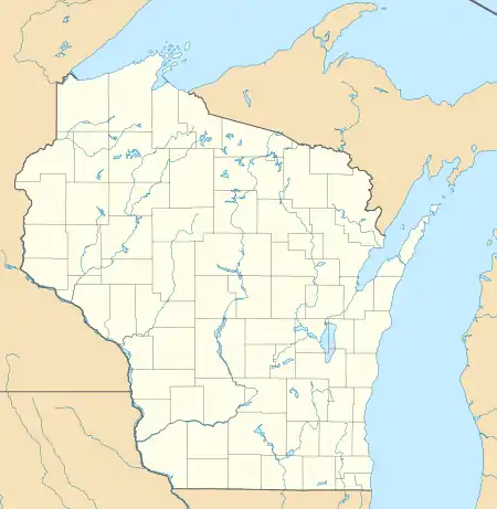
| County | Marinette |
| Elevation | 211 m (692 ft) |
| Time zone | UTC-6 (Central (CST)) |
| • Summer (DST) | UTC-5 (CDT) |
| Area code(s) | 715 & 534 |
| GNIS feature ID | 1569158[1] |
Geography
McAllister is located at the intersection of Wisconsin Highway 180 and County Highway JJ 11.5 miles (18.5 km) east-southeast of Wausaukee[2] at an elevation of 692 feet (211 m).[1] It is connected by road to Wausaukee to the west, Packard to the north, Wagner to the south, and Wallace, Michigan to the east via a bridge across the Menominee River.[3] There is a Lutheran church in the community, and the Wagner town hall and Tabor Lutheran Cemetery are located to the east.[3]
History
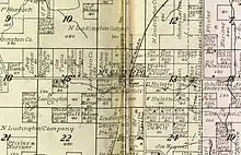
McAllister was a stop between Wagner and Packard on the Wisconsin & Michigan (W. & M.) Railway line from Bagley Junction to Iron Mountain.[4] The rail line through McAllister was discontinued in 1938, when the tracks were torn out and the rolling stock sold off.[4][5][6] A post office was established in McAllister in 1895 and operated until 1966.[7] Segal Haulotte (1871–1939) served as the first postmaster at McAllister; he held the position for 26 years and also operated a general store.[8] Mike Pissato operated a cheese factory in McAllister in the 1920s.[9] The cheese factory was purchased by Theodore Phillips in 1929.[10] In 1946, the Franciscan Friars of the Assumption of the Blessed Virgin Mary Province in Pulaski purchased a riverside property in McAllister as a summer camp and retreat, dubbing it Villa Alvernia.[11]
References
- "McAllister, Wisconsin". Geographic Names Information System. United States Geological Survey.
- Marinette County (PDF) (Map). Wisconsin Department of Transportation. Archived from the original (PDF) on June 14, 2011. Retrieved August 9, 2011.
- Stephenson Quadrangle Wisconsin–Michigan, 15 Minute Series (Topographic). 1963. Map, 1:62,500. Washington, DC: U. S. Geological Survey.
- McLeod, Richard (1968). "History of the Wisconsin and Michigan Railway". The Railway and Locomotive Historical Society Bulletin. 118: 7–20.
- "Seek Permission to Abandon Lines". The Oshkosh Northwestern. April 10, 1937. p. 17. Retrieved August 4, 2019 – via Newspapers.com.

- "Approve Wisconsin and Michigan Ry. Line Abandonment". The Daily Tribune. January 20, 1938. p. 5. Retrieved August 4, 2019 – via Newspapers.com.
- "Wisconsin. Marinette County". Jim Forte Postal History. Retrieved August 2, 2019.
- "Hold Last Rites for McAllister Postmaster". Green Bay Press-Gazette. May 6, 1939. p. 4. Retrieved August 2, 2019 – via Newspapers.com.
- Wisconsin Dairy Statistics for 1927. List of Butter Factories, Cheese Factories, Condenseries and Receiving Stations: July, 1928. Madison, WI: Dairy and Food Commissioner. 1928. p. 73. Retrieved August 2, 2019.
- "Pound News Notes". Green Bay Press-Gazette. March 16, 1929. p. 4. Retrieved August 2, 2019 – via Newspapers.com.
- Chronicle of the Assumption of the Blessed Virgin Mary Province, Pulaski, Wisconsin 20 (1966), pp. 89, 205.
External links
 Media related to McAllister, Wisconsin at Wikimedia Commons
Municipalities and communities of Marinette County, Wisconsin, United States | ||
|---|---|---|
| Cities | 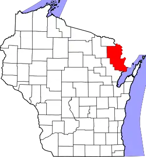 | |
| Villages | ||
| Towns | ||
| CDPs | ||
| Unincorporated communities | ||
| Footnotes | ‡This populated place also has portions in an adjacent county or counties | |
| ||