Peshtigo, Wisconsin
Peshtigo is a city in Marinette County, Wisconsin, United States. The population was 3,502 at the 2010 census. The city is surrounded by the Town of Peshtigo. It is part of the Marinette, WI–MI Micropolitan Statistical Area. Peshtigo is most famous as the site of the Peshtigo fire of 1871, in which more than 1,200 people perished.
Peshtigo | |
|---|---|
City | |
 Peshtigo from former U.S. Route 41 | |
 Location of Peshtigo in Marinette County, Wisconsin. | |
 Peshtigo Location within the state of Wisconsin | |
| Coordinates: 45°3′14″N 87°44′46″W | |
| Country | |
| State | |
| County | Marinette |
| Area | |
| • Total | 3.08 sq mi (7.99 km2) |
| • Land | 2.91 sq mi (7.54 km2) |
| • Water | 0.17 sq mi (0.44 km2) |
| Population | |
| • Total | 3,502 |
| • Estimate (2019)[3] | 3,345 |
| • Density | 1,148.30/sq mi (443.43/km2) |
| Time zone | UTC-6 (Central (CST)) |
| • Summer (DST) | UTC-5 (CDT) |
| Area code(s) | 715 & 534 |
| FIPS code | 55-62175 |
| Website | ci |

History
Name
Peshtigo took its name from the nearby Peshtigo River.[4] The etymology of Peshtigo is uncertain.[5] Explanations include an Ojibwe word meaning 'river of the wild goose',[6][7] a Menominee word for 'snapping turtle',[8][9] a word meaning 'passing through a marsh',[10] or a reference to a local Menominee band known as Pesh-tiko.[5]
Peshtigo fire
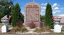
On October 8, 1871, a forest fire driven by strong winds totally consumed Peshtigo and a dozen other villages, killing between 1,200 and 2,500 people and engulfing approximately 1.5 million acres (6,000 km2). This fire, known as the Peshtigo fire, was the deadliest in American history.[11] Unidentifiable remains of hundreds of residents were buried in a mass grave at the Peshtigo Fire Cemetery. The Peshtigo Fire Museum features several items that survived the fire, plus other artifacts from the area's history.[12]
This fire happened on the same day as the Great Chicago fire, the Holland, Michigan fire, the Port Huron Fire of 1871, and the Great Michigan Fire in Manistee, Michigan.
Geography
Peshtigo is located at 45°3′13″N 87°44′45″W (45.053759, −87.746028).[13]
According to the United States Census Bureau, the city has a total area of 3.20 square miles (8.29 km2), of which, 3.03 square miles (7.85 km2) is land and 0.17 square miles (0.44 km2) is water.[14]
Demographics
| Historical population | |||
|---|---|---|---|
| Census | Pop. | %± | |
| 1890 | 1,719 | — | |
| 1910 | 1,975 | — | |
| 1920 | 1,440 | −27.1% | |
| 1930 | 1,579 | 9.7% | |
| 1940 | 1,947 | 23.3% | |
| 1950 | 2,279 | 17.1% | |
| 1960 | 2,504 | 9.9% | |
| 1970 | 2,836 | 13.3% | |
| 1980 | 2,807 | −1.0% | |
| 1990 | 3,154 | 12.4% | |
| 2000 | 3,357 | 6.4% | |
| 2010 | 3,502 | 4.3% | |
| 2019 (est.) | 3,345 | [3] | −4.5% |
| U.S. Decennial Census[15] | |||
2010 census
At the 2010 census there were 3,502 people, 1,469 households, and 888 families living in the city. The population density was 1,155.8 inhabitants per square mile (446.3/km2). There were 1,621 housing units at an average density of 535.0 per square mile (206.6/km2). The racial makup of the city was 96.8% White, 0.1% African American, 0.7% Native American, 1.2% Asian, 0.2% from other races, and 1.1% from two or more races. Hispanic or Latino of any race were 1.2%.[2]
Of the 1,469 households 30.9% had children under the age of 18 living with them, 43.2% were married couples living together, 12.3% had a female householder with no husband present, 5.0% had a male householder with no wife present, and 39.6% were non-families. 35.4% of households were one person and 14.5% were one person aged 65 or older. The average household size was 2.21 and the average family size was 2.82.
The median age was 43.2 years. 23.2% of residents were under the age of 18; 6.8% were between the ages of 18 and 24; 22.1% were from 25 to 44; 25.4% were from 45 to 64; and 22.5% were 65 or older. The gender makeup of the city was 46.9% male and 53.1% female.
2000 census
At the 2000 census there were 3,357 people, 1,315 households, and 879 families living in the city. The population density was 1,101.8 people per square mile (425.0/km2). There were 1,416 housing units at an average density of 464.8 per square mile (179.3/km2). The racial makup of the city was 98.00% White, 0.12% Black or African American, 0.48% Native American, 0.57% Asian, 0.03% Pacific Islander, 0.09% from other races, and 0.71% from two or more races. 0.74% of the population were Hispanic or Latino of any race.[16] Of the 1,315 households 32.9% had children under the age of 18 living with them, 54.8% were married couples living together, 8.5% had a female householder with no husband present, and 33.1% were non-families. 28.7% of households were one person and 15.1% were one person aged 65 or older. The average household size was 2.39 and the average family size was 2.92.
The age distribution was 24.5% under the age of 18, 7.1% from 18 to 24, 26.8% from 25 to 44, 20.3% from 45 to 64, and 21.1% 65 or older. The median age was 40 years. For every 100 females, there were 87.8 males. For every 100 females age 18 and over, there were 84.0 males.
The median household income was $34,898 and the median family income was $41,900. Males had a median income of $31,815 versus $21,531 for females. The per capita income for the city was $16,379. About 5.6% of families and 8.2% of the population were below the poverty line, including 9.7% of those under age 18 and 4.8% of those age 65 or over.
Education
The Peshtigo School District provides public education for the Peshtigo area.[17]
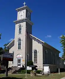
St. John Lutheran School is a Pre-K-8 grade school of the Wisconsin Evangelical Lutheran Synod in Peshtigo.[18]
Modern culture
The fictional character Caroline Duffy from the TV show Caroline in the City came from Peshtigo. The city was mentioned on the show many times.
Images
 Sign
Sign The Peshtigo River in downtown Peshtigo
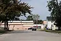 Peshtigo Middle / High School
References
- "2019 U.S. Gazetteer Files". United States Census Bureau. Retrieved August 7, 2020.
- "U.S. Census website". United States Census Bureau. Retrieved 2012-11-18.
- "Population and Housing Unit Estimates". United States Census Bureau. May 24, 2020. Retrieved May 27, 2020.
- Chicago and North Western Railway Company (1908). A History of the Origin of the Place Names Connected with the Chicago & North Western and Chicago, St. Paul, Minneapolis & Omaha Railways. p. 113.
- Voegl, Virgil J. 1991. Indian Names on Wisconsin's Map. Madison: University of Wisconsin Press, pp. 40–41.
- Gannett, Henry. 1905. The Origin of Certain Place Names in the United States. Washington: Government Printing Office, p. 243.
- Bergstrom, Bill. 2003. Peshtigo. Philadelphia: Xlibris, p. 24.
- Haines, Elijah Middlebrook. 1888. The American Indian. Chicago: Mas-sinna'-gan, p. 772.
- Gard, Robert Edward, & Leland George Sorden. 1962. Wisconsin Lore: Antics and Anecdotes of Wisconsin People and Places. New York: Duell, Sloan and Pearce, p. 357.
- Collections of the State Historical Society of Wisconsin. 1911. Madison: State Historical Society of Wisconsin, p. 334.
- Biondich, S. (2010-06-09). "The Great Peshtigo Fire". Shepherd Express. Retrieved 2011-11-09.
- "The Great Peshtigo Fire of 1871". Retrieved 24 December 2014.
- "US Gazetteer files: 2010, 2000, and 1990". United States Census Bureau. 2011-02-12. Retrieved 2011-04-23.
- "US Gazetteer files 2010". United States Census Bureau. Archived from the original on 2012-01-24. Retrieved 2012-11-18.
- "Census of Population and Housing". Census.gov. Retrieved June 4, 2015.
- "U.S. Census website". United States Census Bureau. Retrieved 2008-01-31.
- "St. John Lutheran School".
External links
| Wikimedia Commons has media related to Peshtigo, Wisconsin. |
| Surrounding communities |
| 
 |
|---|---|---|
| Counties | ||
Municipalities and communities of Marinette County, Wisconsin, United States | ||
|---|---|---|
| Cities | 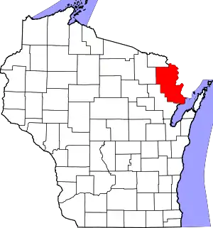 | |
| Villages | ||
| Towns | ||
| CDPs | ||
| Unincorporated communities | ||
| Footnotes | ‡This populated place also has portions in an adjacent county or counties | |
| ||
| Authority control |
|---|
