McIntyre Bluff
McIntyre Bluff is a large ridge of rock, made of gneiss,[2] located south of Vaseux Lake between Okanagan Falls and Oliver in British Columbia, Canada. The bluff rises prominently over the surrounding valley and is one of the most well known landmarks in the Okanagan.
| McIntyre Bluff | |
|---|---|
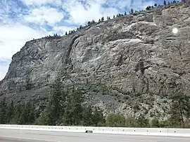 View of McIntyre Bluff from Highway 97 | |
| Highest point | |
| Elevation | 673 m (2,208 ft) |
| Prominence | 260 m (850 ft) |
| Coordinates | 49°15′17″N 119°32′06″W [1] |
| Geography | |
 McIntyre Bluff Location in British Columbia, Canada. | |
| Location | Okanagan, British Columbia, Canada |
| Topo map | NTS 82E/5 |
History
First Nations in the area tell a story of a battle centuries ago on top of McIntyre Bluff. An enemy war party from the south (now Washington state) was lured to the top and driven over the cliffs.
McIntyre Bluff is named after Peter McIntyre, one of the Overlanders of 1862 who had also been a guard on the Pony Express in the American West.[1] He was known as an "Indian Fighter". In 1886 he received a land grant beside this great precipice.[3]:169
Conservation
Most of the bluff is located within White Lake Grasslands Protected Area, which protects the Okanagan dry forests ecosystem located on top of it.
See also
References
- "McIntyre Bluff". BC Geographical Names.
- "Geology of the Southern Okanagan Valley Shear Zone" (PDF). Canadian Tectonics Group - Fieldtrip October 2010. 2010. p. 8. Retrieved 7 March 2014.
- Akrigg, G.P.V.; Akrigg, Helen B. (1986), British Columbia Place Names (3rd, 1997 ed.), Vancouver: UBC Press, ISBN 0-7748-0636-2
External links
 Media related to McIntyre Bluff at Wikimedia Commons
