Okanagan dry forests
Okanagan dry forests is a temperate coniferous forest ecoregion in the Pacific Northwest of North America, as defined by the World Wildlife Fund (WWF) categorization system. It is closely associated with the Okanagan region of British Columbia and Washington.
| Okanagan Dry Forests | |
|---|---|
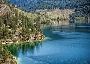 Dry forest along the north shore of Kalamalka Lake | |
 | |
| Ecology | |
| Realm | Nearctic |
| Biome | Temperate coniferous forests |
| Borders | Cascade Mountains leeward forests, Fraser Plateau and Basin complex, North Central Rockies forests and Palouse grasslands |
| Bird species | 199[1] |
| Mammal species | 79[1] |
| Geography | |
| Area | 53,354 km2 (20,600 sq mi) |
| Countries | Canada and United States |
| States | British Columbia and Washington |
| Conservation | |
| Conservation status | Critical/Endangered |
| Habitat loss | 0.5%[1] |
| Protected | 9.52%[1] |
Geography
This ecoregion occupies the south-central interior of British Columbia and adjacent Washington state between the Rocky Mountains to the east and the Pacific Ranges to the west. It is composed of gently rolling hills of Tertiary sediments and volcanic rocks between 1220-1525 metres (4000-5000 ft) in elevation. These hills are incised by numerous bodies of water such as the Columbia River, Thompson River, and Okanagan Lake.
Climate
The ecoregion has a cold semi-arid climate (Köppen BSk) with very warm to hot, dry summers and moderately cool winters with little snowfall. A strong elevational gradient in precipitation occurs, ranging from 250 mm (9.8 in) to over 1000 mm (39.4 in) per year. On average, precipitation is in the range of 400 mm (15.75 in) on the plateaus. The mean annual temperature is around 7°C (44.6°F), mean summer temperature ranges from 15°C (59°F) to 16.5°C (61.7°F), and mean winter temperature is around -2.5°C (27.5°F).
The driest place in Canada outside of the Arctic is in the Kamloops region of Thompson Country, which falls within the northwestern bounds of this ecoregion.[2]
The Okanagan dry forests ecoregion is sometimes referred to as a desert due to its hot, dry climate relative to the rest of Canada.[3] However, it and the neighbouring Columbia Plateau ecoregion near Osoyoos are semi-arid ecoregions and are not true deserts.[4]
Ecology
Flora
Vegetative cover in this region encompasses forests and grasslands that change in character with increasing altitude. Lower elevations contain communities of ponderosa pine, bluebunch wheatgrass, blue grass, June-grass, and Great Basin sagebrush. Mid-slope elevations are home to communities of Douglas-fir and pinegrass. Higher elevations are home to communities lodgepole pine, quaking aspen, white spruce, and Douglas-fir.
Fauna
Large mammals that inhabit this ecoregion include American black bear, bighorn sheep, black-tailed and white-tailed deer, North American river otter, American badger, coyote, bobcat, and cougar. Birds that inhabit this ecoregion include California quail, blue grouse, long-billed curlew, and waterfowl.
Threats and preservation
.jpg.webp)
Approximately 20% of the Okanagan dry forests remains intact, with most parts having been heavily altered due to clearing of land for agricultural production. Growing urban expansion also threatens this ecoregion, most notably around the cities of Kamloops, Kelowna, and Spokane.[4] Connectivity between grasslands for wildlife is heavily impaired by the development of lowland valleys.
Human-caused climate change threatens to increase the frequency and intensity of droughts and wildfires in this ecoregion. Wildfires of note include the 2003 Okanagan Mountain Park fire, 2009 West Kelowna wildfires, and 2017 British Columbia wildfires.[5][6]
Protected areas
Some of the largest protected areas of this ecoregion include:
References
- "The Atlas of Global Conservation". The Nature Conservancy. Retrieved 2020-08-18.
- "WeatherStats: Weather Winners". Amateur Weather Statistics for Kamloops, British Columbia. Retrieved 2020-08-20.
- Society, The Royal Canadian Geographic (2014-10-16). "Desert - Ecozones - Return to the Wild". www.canadiangeographic.com. Retrieved 2020-08-20.
- G.G.E. Scudder (15 February 1999). "The Osoyoos Desert Society: Experimental Studies on Ecological Restoration of the Shrub-Steppe Habitat; In: Proceedings of a Conference on the Biology and Management of Species and Habitats at Risk, Kamloops, B.C" (PDF). B.C. Ministry of Environment, Lands and Parks, Victoria, B.C. and University College of the Cariboo, Kamloops, B.C. Retrieved 18 February 2019.
- Klenner, Walt; Walton, Russ; Arsenault, André; Kremsater, Laurie (28 February 2008). "Dry forests in the Southern Interior of British Columbia: Historic disturbances and implications for restoration and management" (PDF). USFS Forest Ecology and Management. 256: 1711–1722 – via ScienceDirect.
- "This is British Columbia's Second-Worst Wildfire Season. It's Far From Over". www.climatecentral.org. Retrieved 2020-08-20.
External links
| Wikimedia Commons has media related to Okanagan dry forests. |
- "Okanagan dry forests". Terrestrial Ecoregions. World Wildlife Fund.