Meadow, South Dakota
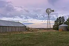
Meadow is an unincorporated community in Perkins County, South Dakota, United States. Meadow is twelve miles east of Bison and two miles from the junction of South Dakota Highways 20 and 73. Although not tracked by the Census Bureau, Meadow has been assigned the ZIP code of 57644. There is a post office located within the town of Meadow. The surrounding area is farming and ranching land.
Meadow, South Dakota | |
|---|---|
| Coordinates: 45°30′10″N 102°15′35″W | |
| Country | United States |
| State | South Dakota |
| County | Perkins |
| Area | |
| • Total | 35.8 sq mi (92.8 km2) |
| • Land | 35.6 sq mi (92.1 km2) |
| • Water | 0.3 sq mi (0.7 km2) |
| Elevation | 2,703 ft (824 m) |
| Population (2000) | |
| • Total | 35 |
| • Density | 1.0/sq mi (0.4/km2) |
| Time zone | UTC-7 (Mountain (MST)) |
| • Summer (DST) | UTC-6 (MDT) |
| ZIP code | 57644 |
| Area code(s) | 605 |
| FIPS code | 46-41660[1] |
| GNIS feature ID | 1269126[2] |
Meadow was laid out in 1907, and named for a vast meadow near the original town site.[3]
Meadow is located approximately 15.5 miles to the west from what was the farthest point from any McDonald's restaurant in the contiguous United States in 2009, prior to that point moving 45.45955°N 101.91356°W.[4] Along with Glad Valley, South Dakota, Meadow is one of the nearest communities to that point.[5]
References
- "U.S. Census website". United States Census Bureau. Retrieved 2008-01-31.
- "US Board on Geographic Names". United States Geological Survey. 2007-10-25. Retrieved 2008-01-31.
- Federal Writers' Project (1940). South Dakota place-names, v.1-3. University of South Dakota. p. 50.
- Von Worley, Stephen. "Where The Buffalo Roamed". Weather Sealed. Retrieved September 23, 2009.
- "A McDonald's Is Never More Than 107 Miles Away". Huffington Post. Retrieved 15 July 2018.
Municipalities and communities of Perkins County, South Dakota, United States | ||
|---|---|---|
| City | 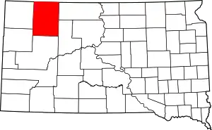 | |
| Town | ||
| Townships |
| |
| CDP | ||
| Other unincorporated communities | ||
| Ghost towns | ||
| Indian reservation | ||
| Footnotes | ‡This populated place also has portions in an adjacent county or counties | |
| ||