Medicine Bow River
The Medicine Bow River is a 167-mile-long (269 km)[1] tributary of the North Platte River, in southern Wyoming in the United States.
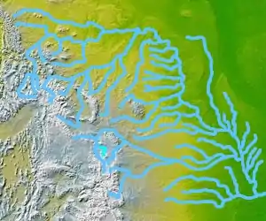
The Medicine Bow River
| Medicine Bow River | |
|---|---|
| Physical characteristics | |
| Source | |
| • location | Snowy Range, Carbon County, Wyoming |
| Mouth | |
• location | Seminoe Reservoir, Carbon County, Wyoming |
• elevation | 6,360 feet (1,940 m) |
| Length | 167 miles (269 km) |
| Basin size | 2,338 square miles (6,060 km2) |
It rises in the Snowy Range, flowing out of the North Gap Lake, in southeastern Carbon County. It flows north, past Elk Mountain, then northeast, then northwest past the town of Medicine Bow and between the Shirley Mountains to the north and the Medicine Bow Mountains to the south. Near the town of Medicine Bow the Medicine Bow River is joined by its two largest tributaries, Rock Creek and the Little Medicine Bow River. It joins the North Platte in the Seminoe Reservoir, with the lower 10 miles (16 km) of the river forming an arm of the reservoir.
Discharge statistics
| Statistic | Time period | Discharge |
|---|---|---|
| Yearly mean discharge | year | 176cf/s |
| Month with highest mean discharge | June | 648cf/s |
| Month with lowest mean discharge | January | 32.2cf/s |
See also
References
- U.S. Geological Survey. National Hydrography Dataset high-resolution flowline data. The National Map Archived 2012-04-05 at WebCite, accessed March 21, 2011
External links
| Authority control |
|
|---|
This article is issued from Wikipedia. The text is licensed under Creative Commons - Attribution - Sharealike. Additional terms may apply for the media files.
