Meta River
The Meta River is a major left tributary of the Orinoco River in eastern Colombia and southern Venezuela, South America. The Meta originates in the Eastern Ranges of the Andes and flows through the Meta Department, Colombia as the confluence of the Humea, Guatiquía and Guayuriba rivers. It flows east-northeastward across the Llanos Orientales ("Eastern Plains") of Colombia following the direction of the Meta Fault.[1] The Meta forms the northern boundary of Vichada Department, first with Casanare Department, then with Arauca Department, and finally with Venezuela, down to Puerto Carreño where it flows into the Orinoco.
| Meta River | |
|---|---|
 | |
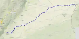 Course of the Río Meta. | |
.jpg.webp) | |
| Location | |
| Country | Colombia Venezuela |
| Physical characteristics | |
| Source | |
| • location | Colombia |
| • elevation | c. 1,300 metres (4,300 ft) |
| Mouth | |
• location | Orinoco at Puerto Carreño |
• coordinates | 6.19517°N 67.4564°W |
| Length | 804 kilometres (500 mi) |
| Basin size | 93,800 square kilometres (36,200 sq mi) |
The Meta River is 804 kilometres (500 mi) long and its drainage basin is 93,800 square kilometres (36,200 sq mi). The Meta divides the Colombian Llanos in two different parts: the western portion on the left bank is more humid, receives the relatively nutrient-rich sediments from the Andean mountain range and therefore soils and tributaries are also nutrient-rich, while the eastern portion, high plain or altillanura, drains not to the Meta river but to the Orinoco, has a longer dry season and soils and surface waters are oligotrophic (nutrient poor).
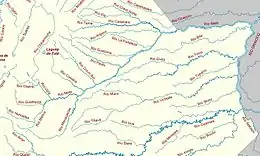
The major tributaries of the Meta are the Cravo Sur, the Casanare, the Cusiana, the Upía and the Manacacías rivers.
History
An 1856 watercolor by Manuel María Paz, of three indigenous people with a boat at Orocué, near the Old Macuco Mission, is an early depiction of life on the river.[2]
Indigenous groups
Living along the Meta are various indigenous groups. In the upper part of the river, close to the foothills of the Eastern Ranges and farther downstream, the Guayupe, Achagua, Sáliva and Guahibo people are living.[1]
Economy
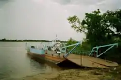
Starting at Puerto López the Meta becomes navigable, and thus is an important component of the trade across the Colombian and Venezuelan Llanos.
References
- (in Spanish) Indígenas de los Llanos Orientales - Banco de la República
- Paz, Manuel María. "View of the River Meta from Orocué, near the Old Macuco Mission, Province of Casanare". World Digital Library. Retrieved 2014-05-21.
