Metro Center station
Metro Center station is the central hub station of the Washington Metro rapid transit system in Washington, D.C. The station is located in downtown Washington, centered on the intersection of 12th Street NW and G Street NW. It is the second busiest station in the Metrorail system after Union Station, averaging 30,500 passengers per weekday as of May 2006.[2] The Red Line portion of Metro Center station opened on March 27, 1976, as part of the first section of the Metro system.
Metro Center | |||||||||||||||||||||||||
|---|---|---|---|---|---|---|---|---|---|---|---|---|---|---|---|---|---|---|---|---|---|---|---|---|---|
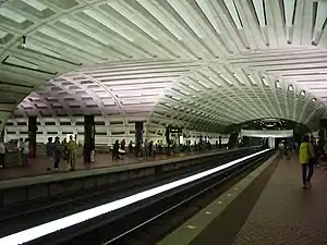 The crossed vaults at Metro Center station | |||||||||||||||||||||||||
| Location | 12 Street NW at G Street NW, Washington, D.C. | ||||||||||||||||||||||||
| Coordinates | 38.898303°N 77.028099°W | ||||||||||||||||||||||||
| Platforms | 2 side platforms (upper level) 1 island platform (lower level) | ||||||||||||||||||||||||
| Tracks | 4 (2 upper level, 2 lower level) | ||||||||||||||||||||||||
| Connections | |||||||||||||||||||||||||
| Construction | |||||||||||||||||||||||||
| Depth |
| ||||||||||||||||||||||||
| Bicycle facilities | 8 racks | ||||||||||||||||||||||||
| Disabled access | Yes | ||||||||||||||||||||||||
| Other information | |||||||||||||||||||||||||
| Station code | A01 (upper level) C01 (lower level) | ||||||||||||||||||||||||
| History | |||||||||||||||||||||||||
| Opened | March 27, 1976 | ||||||||||||||||||||||||
| Passengers | |||||||||||||||||||||||||
| 2016 | 24,160 daily[1] | ||||||||||||||||||||||||
| Services | |||||||||||||||||||||||||
| |||||||||||||||||||||||||
Station layout
Metro Center station is laid out in two underground levels in a cross shape centered on the intersection of 12th Street NW and G Street NW, with The lower level runs north-south under 12th Street between F Street and H Street, with one island platform for the Orange Line, Silver Line, and Blue Line. The upper level runs east-west under G Street between 11th Street and 13th Street, with two side platforms for the Red Line, with wide corridors above the lower level platform and tracks. Mezzanines are located above the tracks at both ends of the upper platforms.
Entrances are located on G Street at 11th Street (southeast corner), 12th Street (northwest corner), and 13th Street (southeast corner); and at the southwest corner of 12th Street and F Street. Only the 12th Street and G Street entrance has a surface elevator.
| G | Street level | Exit/entrance, buses |
| B1 | Mezzanines | Fare control, ticket machines, station agent |
| B2 | Side platform | |
| Westbound | ← | |
| Eastbound | | |
| Side platform | ||
| B3 | Westbound | ← ← ← |
| Island platform | ||
| Eastbound | | |
History
Metro Center was one of the original 6 stations to open with the first section of the Red Line on March 27, 1976. The upper level with the Red Line opened on March 27, 1976 with the rest of the initial segment from Dupont Circle station to Rhode Island Avenue-Brentwood station. The lower level opened on July 1, 1977 with the initial segment of the Blue Line from Reagan National Airport to Stadium-Armory station. Orange Line service began on November 20, 1979 with the opening of the segment from Stadium-Armory to New Carrollton Station. Silver line service began on July 26, 2016 with the opening of the segment from East Falls Church to Wiehle-Reston East.[3]
A pedestrian tunnel to nearby Gallery Place–Chinatown station has been proposed to connect all six Metro lines within fare control. A study was published in July 2005.[4]
Between January 16 to January 21, 2021, this station was closed because of security concerns due to the 2020 Inauguration.[5]
References
- "Metrorail Average Weekday Passenger Boardings" (PDF). WMATA. Retrieved April 26, 2017.
- "Request for Expressions of Interest for Operation of Retail Services in Metrorail Stations" (PDF). WMATA. February 16, 2007. Archived from the original (PDF) on September 27, 2007.
- Alberto, Cuadro; Denise, Lu (April 27, 2015). "How D.C. Metro grew over the years". The Washington Post. Retrieved August 3, 2020.
- Parsons; KPG Design Studio; Basile Baumann Prost & Associates (July 2005). "Gallery Place/Chinatown - Metro Center Pedestrian Passageway Tunnel Study" (PDF). WMATA Office of Planning and Project Development. Archived from the original (PDF) on February 14, 2014.
- "Metro announces Inauguration service plans, station closures | WMATA". www.wmata.com. Retrieved January 13, 2021.
External links
| Wikimedia Commons has media related to Metro Center station. |
- Entrances on Google Maps Street View: G Street and 13th Street, G Street and 12th Street, G Street and 11th Street, F Street and 12th Street