Metropolitan City of Milan
The Metropolitan City of Milan (Italian: città metropolitana di Milano; Milanese: cittaa metropolitana de Milan [tʃiˈtɑː metrupuliˈtana de miˈlãː]) is a metropolitan city in the Lombardy region, Italy. It's the second most populous Metropolitan City in the nation after the Metropolitan City of Rome. Its capital is the city of Milan. It replaced the Province of Milan and includes the city of Milan and other 133 municipalities or communes (comuni). It was first created by the reform of local authorities (Law 142/1990) and then established by the Law 56/2014. It has been operative since 1 January 2015.
Metropolitan City of Milan | |
|---|---|
 Flag  Coat of arms | |
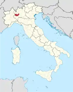 Location of the Metropolitan City of Milan | |
| Country | |
| Region | |
| Established | 1 January 2015 |
| Capital(s) | Milan |
| Comuni | 134 |
| Government | |
| • Metropolitan Mayor | Giuseppe Sala |
| Area | |
| • Total | 1,575 km2 (608 sq mi) |
| Population (June 2019) | |
| • Total | 3,259,835 |
| • Density | 2,100/km2 (5,400/sq mi) |
| Time zone | UTC+1 (CET) |
| • Summer (DST) | UTC+2 (CEST) |
| ISTAT | 215[1] |
| Website | Metropolitan City of Milan |
The Metropolitan City of Milan is headed by the Metropolitan Mayor (Sindaco metropolitano) and by the Metropolitan Council (Consiglio metropolitano). Since June 2016 Giuseppe Sala, as mayor of the capital city, has been the mayor of the Metropolitan City.
Government
List of Metropolitan Mayors of Milan
| Metropolitan Mayor | Term start | Term end | Party | |
|---|---|---|---|---|
| 1 | Giuliano Pisapia | 1 January 2015 | 21 June 2016 | Independent (centre-left) |
| 2 | Giuseppe Sala | 21 June 2016 | Incumbent | Independent (centre-left) |
Metropolitan Council
The new Metro municipalities, giving large urban areas the administrative powers of a province, are conceived for improving the performance of local administrations and to slash local spending by better coordinating the municipalities in providing basic services (including transport, school and social programs) and environment protection.[2] In this policy framework, the Mayor of Milan is designated to exercise the functions of Metropolitan mayor, presiding over a Metropolitan Council formed by 24 mayors of municipalities within the Metro municipality.
The first Metropolitan Council of the City was elected on 28 September 2014. The current Metropolitan Council of the City (2016-2021) was elected on 9 October 2016:
| Group | Seats | |
|---|---|---|
| PD-SI | 14 / 24 | |
| FI-NCD | 6 / 24 | |
| LN | 2 / 24 | |
| M5S | 1 / 24 | |
| Others | 1 / 24 | |
Administrative regions
The ten most-populous municipalities within the Metropolitan City are:
| Rank | City | Population | Area (km2) |
Density (inhabitants/km2) |
Altitude (mslm) |
|---|---|---|---|---|---|
| 1st | Milan | 1,395,274 | 181.76 | 7355.2 | 122 |
| 2nd | Sesto San Giovanni | 81,750 | 11.74 | 6963.4 | 140 |
| 3rd | Cinisello Balsamo | 74,536 | 12.7 | 5869 | 154 |
| 4th | Legnano | 60,259 | 17.72 | 3357.3 | 199 |
| 5th | Rho | 51,033 | 22.32 | 2286.4 | 158 |
| 6th | Cologno Monzese | 47,880 | 8.46 | 5659.6 | 134 |
| 7th | Paderno Dugnano | 47,750 | 14.1 | 3386.5 | 163 |
| 8th | Rozzano | 41,581 | 13.01 | 3196.1 | 103 |
| 9th | San Giuliano Milanese | 37,235 | 30.71 | 1212.5 | 98 |
| 10th | Pioltello | 36,756 | 13.1 | 2805.8 | 156 |
Transport
Milan metropolitan area is one of southern Europe's key transport nodes and one of Italy's most important railway hubs. Its five major railway stations, among which the Milan Central station, are among Italy's busiest.[3][4]
The Azienda Trasporti Milanesi (ATM) operates within the metropolitan area, managing a public transport network consisting of an underground rapid transit network and tram, trolley-bus and bus lines. Overall the network covers nearly 1,400 km (870 mi) reaching 86 municipalities. Besides public transport, ATM manages the interchange parking lots and other transportation services including bike sharing and car sharing systems.[5]
Milan Metro is the rapid transit system serving the city, with 4 lines and a total length of more than 90 km (56 mi). The recently opened M5 line is undergoing further expansion and the construction of the M4 line has been approved. The Milan suburban railway service comprises 10 lines and connects the metropolitan area with the city centre through the Milan Passerby underground railway. Commonly referred to as "Il Passante", it has a train running every 6 minutes (and in the city functions as a subway line with full transferability to the Milan Metro).
The city tram network consists of approximately 160 kilometres (99 mi) of track and 17 lines.[6] Bus lines cover over 1,070 km (665 mi). Milan has also taxi services operated by private companies and licensed by the City council of Milan. The city is also a key node for the national road network, being served by all the major highways of Northern Italy.
The Milan metropolitan area is served by three international airports. Malpensa International Airport, the second busiest in Italy (about 19 million passengers in 2010), is 45 km (28 mi) from central Milan and connected to the city by the Malpensa Express railway service. Linate Airport, which lies within the city limits and served over 9 million passengers in 2010,[7] and Orio al Serio Airport (60 km or 37 mi from central Milan), are mainly used for domestic and short-haul international flights.
References
| Wikivoyage has a travel guide for Outer Milan. |
| Wikimedia Commons has media related to Metropolitan City of Milan. |
- "Codici delle città metropolitane al 1° gennaio 2017". www.istat.it (in Italian). 23 December 2016.
- Vittorio Ferri (2009). "Metropolitan cities in Italy. An institution of federalism" (PDF). University of Milan-Bicocca. Retrieved 23 May 2011. Cite journal requires
|journal=(help) - "List of major railway stations in Italy with passenger figures". Ferrovie dello Stato. Archived from the original on 22 July 2011. Retrieved 20 September 2011.
- "Milano Centrale station official page on Ferrovie dello stato website". Ferrovie dello Stato. Archived from the original on 24 September 2011. Retrieved 20 September 2011.
- "Carta della Mobilità 2011" (PDF). Azienda Trasporti Milanesi. Archived from the original (PDF) on 29 March 2012. Retrieved 20 September 2011.
- "world.nycsubway.org/Europe/Italy/Milan (Urban Trams)". World.nycsubway.org. 8 December 2003. Retrieved 13 March 2009.
- "Linate and Malpensa airports: Key Facts". SEA – Società Esercizi Aeroportuali. Archived from the original on 1 June 2011. Retrieved 20 September 2011.
| Provinces and places | 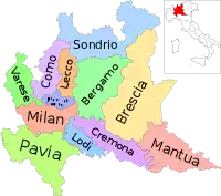 | |
|---|---|---|
| History | ||
| Politics and government |
| |
| Education and culture | ||
Categories | ||
| Metropolitan cities | |
|---|---|
| Metropolitan areas | |
| Authority control |
|---|