Middle Prong Wilderness
Middle Prong Wilderness was designated in 1984 and it covers 7,900 acres (32 km2) within the Pisgah National Forest in Haywood County, Western North Carolina. The Wilderness Area spans steep, rugged high-elevation ridges ranging from 3,200 to over 6,400 feet, and the area gets its name from the Middle Prong of the Pigeon River finding whose headwaters are located in the area.[1] NC 215 separates from Shining Rock Wilderness to the northeast.
| Middle Prong Wilderness | |
|---|---|
IUCN category Ib (wilderness area) | |
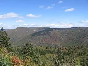 Middle Prong Wilderness in North Carolina | |
 | |
| Location | Haywood County, North Carolina, USA |
| Nearest city | Brevard |
| Coordinates | 35°20′20″N 82°56′14″W |
| Area | 7,900 acres (32 km2) |
| Established | 1984 |
| Governing body | U.S. Forest Service |
| Website | Middle Prong Wilderness |
References
-
 This article incorporates public domain material from the United States Department of Agriculture document: "Middle Prong Wilderness". Retrieved 2011-09-06.
This article is issued from Wikipedia. The text is licensed under Creative Commons - Attribution - Sharealike. Additional terms may apply for the media files.