Mill Creek Ravine
Mill Creek Ravine is located Edmonton, Alberta, Canada and is a part of the River Valley parks and trail system. The end of the ravine opens onto the North Saskatchewan River valley near the west end of Cloverdale on the opposite bank from downtown.
| Mill Creek Ravine | |
|---|---|
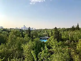 View of Mill Creek Ravine looking north, with the Mill Creek Pool in the foreground and downtown skyline in the background | |
| Location | |
| Country | Canada |
| Province | Alberta |
| Physical characteristics | |
| Source | |
| • location | Alberta |
| Mouth | |
• location | North Saskatchewan River |
• coordinates | 53°32′23″N 113°28′41″W |
Geography
The creek begins in rural sloughs just south and east of Anthony Henday Drive (just south of its junction with Highway 14 and to the south-east of the Meadows community), and flows northward to an outfall near 92 Avenue between the neighborhoods of Strathcona and Bonnie Doon. Large segments of the creek were diverted into culverts during the 1960s and 1970s including a section that runs underneath the Davies/Coronet Industrial areas in the city's south-east. The lower reaches of the creek were diverted to a tunnel and concrete outfall structure north of 88th Avenue. The outfall emerges on the east bank of the North Saskatchewan River several meters above the river at approximately 95 Avenue. It is clearly visible from the James MacDonald Bridge. The city has begun public consultations on re-establishing the natural, surface flow ("daylighting") the downstream reach of Mill Creek.[1]
History
The creek is named after a flour mill that was established by William Bird in 1878.[2]
The ravine was once home to part of the Edmonton, Yukon & Pacific Railway line. The line ran from the Canadian Pacific line at about 67 Avenue, across 99 Street, and down into Mill Creek Ravine. The rail-line went down through the ravine and out across the Low Level Bridge. The railway carried passengers and also served ravine industries -- a brickyard, a coal mine and two meat packing plants. Gainer's meat packing plant, a large scale meat packing facility, was once located on the western edge of the ravine at 79 Avenue.[3]
.jpg.webp)
In 1954 most of the railway through the ravine was abandoned, with only the section serving the meat packing plant, running from 79 Avenue to the CPR line, remaining in use. This section was abandoned by 1980. In the early 1980s the City of Edmonton converted the railway right of way between 67 Avenue to the river into a paved bicycle path, later designated a multi-use trail. Four of the original wooden railway trestles were used by the path. The largest of these, the Mill Creek Trestle at 76 Avenue, was recognized as a Municipal Historic Resource in 2004 and still stands.[4] The three shorter trestles were extensively rehabilitated in 2017–18, with the shortest one being completely replaced. Concrete abutments were added, concrete footings were placed under wooden pilings, all mid-stream pilings were replaced with trusses, and the bridge decks were widened.[5][6] The original wood from the trestles was reused where possible.[7] In 1988 the Edmonton Historical Board erected a plaque in Mill Creek Park commemorating the railway.
Local residents and nature enthusiasts fought successfully to prevent the City from installing a freeway through the ravine in the 1960s and 1970s.[8]
The city has begun public consultations on re-establishing the natural, surface flow ("daylighting") the downstream reach of Mill Creek, north of 88th Avenue.[9]
The Mill Creek Outdoor Swimming Pool, located in the ravine at 8200 - 95A Street, is a popular summertime destination. Other nearby attractions include the Argyll Velodrome and BMX course and the Muttart Conservatory.[10]
Notable events
On July 4, 1908, two people drowned in Mill Creek in isolated incidents, two hours apart from each other.[11] Both drownings occurred at the same location, where the creek connected with the North Saskatchewan River.
In 1996 Hisaya Okymia, a young boy, drowned in the creek, near the heritage trestle bridge.
Communities
See also
External links
Notes
- "Mill Creek Daylighting". Natural Areas & Urban Biodiversity. City of Edmonton. April 3, 2018.
- Herzog, Lawrence (March 22, 2007). "Industry on the river". Real Estate Weekly. Archived from the original on September 27, 2007. Retrieved February 19, 2015.
- Herzog, Lawrence (October 12, 2012). "Edmonton's Lost Packing Plants". Edmonton Heritage Council. Archived from the original on November 1, 2012. Retrieved February 19, 2015.
- "Mill Creek Trestle Bridge". Canada's Historic Places. Canadian Register of Historic Places. Retrieved 30 May 2018.
- "Mill Creek Ravine Pedestrian Bridges Rehabilitation" (PDF). City of Edmonton. 27 October 2016. Retrieved 29 October 2020.
- "Mill Creek Pedestrian Bridges - Area Map" (PDF). City of Edmonton. Retrieved 29 October 2020.
- "Bridges Reopen- June 2018". City of Edmonton. Retrieved 29 October 2020.
- Bonnie Doon Community League, Memories of Bonnie Doon, 2019
- "Mill Creek Daylighting". Natural Areas & Urban Biodiversity. City of Edmonton. April 3, 2018.
- Edmonton, City of (2020-01-28). "Mill Creek Ravine". www.edmonton.ca. Retrieved 2020-01-29.
- "Strathcona Evening Chronicle July 4, 1908 Page 1". peel.library.ualberta.ca. Retrieved 2018-11-12.
| Rivers |  Rivers and lakes in Alberta | |
|---|---|---|
| Waterfalls | ||
| Lakes | ||
| Reservoirs | ||
| Glaciers | ||
| Other | ||