Minnesota State Highway 284
Minnesota State Highway 284 (MN 284) is a 5.651-mile-long (9.094 km) highway in Minnesota, which runs from its intersection with U.S. Highway 212 in Cologne and continues to its northern terminus at its intersection with State Highway 5 in Waconia.
| ||||
|---|---|---|---|---|
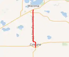
MN 284 highlighted in red | ||||
| Route information | ||||
| Defined by MS § 161.115(215) | ||||
| Maintained by MnDOT | ||||
| Length | 5.651 mi[1] (9.094 km) | |||
| Existed | July 1, 1949[2]–present | |||
| Major junctions | ||||
| South end | ||||
| North end | ||||
| Location | ||||
| Counties | Carver | |||
| Highway system | ||||
| ||||

Route description
Highway 284 serves as a north–south route between Cologne and Waconia.
The roadway is also known as Paul Avenue and Benton Street in the city of Cologne.
The route passes around the east side of Benton Lake in Cologne.[3]
The route is legally defined as Route 284 in the Minnesota Statutes.[4]
History
Highway 284 was authorized on July 1, 1949.[2]
The route was paved at the time it was marked.[5]
Major intersections
The entire route is in Carver County.
| Location | mi[1] | km | Destinations | Notes | |
|---|---|---|---|---|---|
| Cologne | 0.000 | 0.000 | Superstreet intersection | ||
| Waconia | 5.651 | 9.094 | |||
| 1.000 mi = 1.609 km; 1.000 km = 0.621 mi | |||||
References
- Minnesota Department of Transportation (August 14, 2014). "Statewide Trunk Logpoint Listing" (PDF). St. Paul: Minnesota Department of Transportation. Retrieved November 14, 2015.
- "Chapter 663-H.F. No. 1792", Session Laws of Minnesota for 1949, Earl L. Berg, Commissioner of Administration, pp. 1177–1185
- General Highway Map of Carver County (PDF) (Map). Minnesota Department of Transportation. 2010. Archived from the original (PDF) on August 21, 2010. Retrieved May 7, 2010.
- "161.115, Additional Trunk Highways". Minnesota Statutes. Office of the Revisor of Statutes, State of Minnesota. 2010. Retrieved January 24, 2011.
- Minnesota 1950 Official Highway Map (Map). Minnesota Department of Highways. January 1, 1950. § K18. Archived from the original on July 21, 2011. Retrieved January 24, 2011.
External links
This article is issued from Wikipedia. The text is licensed under Creative Commons - Attribution - Sharealike. Additional terms may apply for the media files.