Minnesota State Highway 282
Minnesota State Highway 282 (MN 282) is a 7.655-mile-long (12.320 km) highway in Minnesota, which runs from its intersection with U.S. Highway 169 in Jordan and continues east to its eastern terminus at its intersection with State Highway 13 in Spring Lake Township near Prior Lake.
| ||||
|---|---|---|---|---|
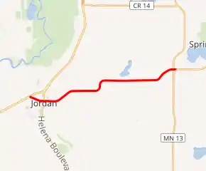
MN 282 highlighted in red | ||||
| Route information | ||||
| Defined by MS § 161.115(213) | ||||
| Maintained by MnDOT | ||||
| Length | 7.655 mi[1] (12.320 km) | |||
| Existed | July 1, 1949[2]–present | |||
| Major junctions | ||||
| West end | ||||
| East end | ||||
| Location | ||||
| Counties | Scott | |||
| Highway system | ||||
| ||||

The route passes through the communities of Jordan, Sand Creek Township, and Spring Lake Township.
Route description

Highway 282 serves as an east–west route between Jordan and Spring Lake Township near Prior Lake.
The route is also known as:
- 2nd Street in the city of Jordan
- Country Trail West in Sand Creek Township
- Country Trail East in Spring Lake Township
Highway 282 has a junction with Marystown Road (County 15) in Sand Creek Township, south of Shakopee.
The route is legally defined as Route 282 in the Minnesota Statutes.[3]
History
Highway 282 was authorized on July 1, 1949.[1]
The route was paved in 1951.[4][5]
From April 2009 to July 2009, the section of Highway 282 in the city of Jordan (2nd Street) was reconstructed between Creek Lane and Broadway Street (Highway 21). New streetlights were installed and the route was given a new pavement surface.
Major intersections
The entire route is in Scott County.
| Location | mi[1] | km | Destinations | Notes | |
|---|---|---|---|---|---|
| Jordan | 0.000 | 0.000 | |||
| 0.733 | 1.180 | ||||
| Sand Creek Township | 1.410 | 2.269 | |||
| 4.901 | 7.887 | ||||
| 5.913 | 9.516 | ||||
| Sand Creek–Spring Lake township line | 6.426 | 10.342 | |||
| Spring Lake Township | 7.590 | 12.215 | |||
| 7.714 | 12.414 | ||||
| 1.000 mi = 1.609 km; 1.000 km = 0.621 mi | |||||
References
- "Trunk Highway Log Point Listing - Construction District 5" (PDF). Minnesota Department of Transportation. August 20, 2010. Archived from the original (PDF) on June 27, 2011. Retrieved January 23, 2011.
- "Chapter 663-H.F. No. 1792", Session Laws of Minnesota for 1949, Earl L. Berg, Commissioner of Administration, pp. 1177–1185
- "161.115, Additional Trunk Highways". Minnesota Statutes. Office of the Revisor of Statutes, State of Minnesota. 2010. Retrieved January 23, 2011.
- 1951 Official Road Map of Minnesota (Map). Cartography by The H.M. Gousha Company. Minnesota Department of Highways. January 1, 1951. § J17. Archived from the original on August 25, 2011. Retrieved January 23, 2011.
- 1952 Official Road Map of Minnesota (Map). Cartography by The H.M. Gousha Company. Minnesota Department of Highways. January 1, 1952. § J17. Archived from the original on July 21, 2011. Retrieved January 23, 2011.
