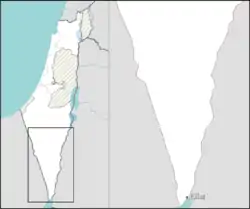
Mitzpe Ramon
Mitzpe Ramon (Hebrew: מִצְפֵּה רָמוֹן, lit. Ramon Lookout; Arabic: متسبي رمون) is a local council in the Negev desert of southern Israel. It is situated on the northern ridge at an elevation of 860 meters (2,800 feet) overlooking the world's largest erosion cirque, known as the Makhtesh Ramon.[2] In 2019 it had a population of 5,211.[1]
Mitzpe Ramon
| |
|---|---|
| Hebrew transcription(s) | |
| • ISO 259 | Miçpe Ramon |
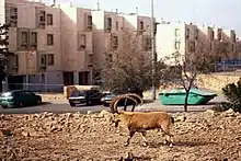
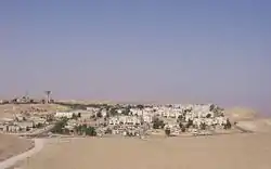 View of Mitzpe Ramon from Har Gamal - 2009 | |
 Mitzpe Ramon  Mitzpe Ramon | |
| Coordinates: 30°36′29″N 34°48′11″E | |
| Country | |
| District | Southern |
| Founded | 1951 |
| Government | |
| • Head of Municipality | Roni Marom |
| Area | |
| • Total | 62,875 dunams (62.875 km2 or 24.276 sq mi) |
| Elevation | 839 m (2,753 ft) |
| Population (2019)[1] | |
| • Total | 5,211 |
| • Density | 83/km2 (210/sq mi) |
| Name meaning | Ramon Lookout |
| Website | mitzpe-ramon |
History
Mitzpe Ramon was founded in 1951 as a camp for the workers building Highway 40. The town's first permanent residents, several young families from Kibbutz Re'im and other parts of Israel began setting there in 1956. After five years, the town was home to 370 residents including 160 children, most of them veteran Israelis. There were also 180 housing units to absorb new immigrants[3] They were joined by immigrants from North Africa, Romania, and India in the 1960s, and it became the southernmost of the Negev's development towns.
Conditions in the early years were harsh, with limited food supplies and practically no modern-day amenities. Ice blocks and provisions were delivered once a week by a supply truck. There was a single school with one classroom for all ages. The homes of the first settlers were prefabricated asbestos barracks. Later, rows of small attached stone houses were built and after that, apartment buildings, beginning in the early 1960s.
In 1972, Mitzpe Ramon had a population of about 1,400 people living in 300 households. The town further grew after Ramon Airbase was completed in 1982. In 1988, the town had a population of about 3,000, and it experienced more significant population growth when it absorbed Soviet immigrants during the 1990s Post-Soviet aliyah.
Geology and climate
Ramon Crater, known as a makhtesh Ramon, is 38 km long, 6 km wide and 450 meters deep.[4]
Mitzpe Ramon's climate borders between hot desert climate and cold desert climate (Köppen climate classification: BWh/BWk), characterized by hot, dry summers and cold winters. There are moderate to strong winds all year long, caused by its location above the crater, which make Mitzpe Ramon feel much colder than it really is. Precipitation is scarce, concentrated around the winter months, with an annual precipitation amount of roughly 70 millimeters (2.75 inches). Snowfall occurs on average once in a couple of years.
| Climate data for Mitzpe Ramon (Temperature: 1987–2010, Precipitation: 1980-2010) | |||||||||||||
|---|---|---|---|---|---|---|---|---|---|---|---|---|---|
| Month | Jan | Feb | Mar | Apr | May | Jun | Jul | Aug | Sep | Oct | Nov | Dec | Year |
| Record high °C (°F) | 28.0 (82.4) |
29.1 (84.4) |
33.5 (92.3) |
36.4 (97.5) |
39.6 (103.3) |
40.9 (105.6) |
39.6 (103.3) |
39.2 (102.6) |
37.8 (100.0) |
37.4 (99.3) |
31.1 (88.0) |
29.0 (84.2) |
40.9 (105.6) |
| Mean maximum °C (°F) | 20.4 (68.7) |
23.1 (73.6) |
27.4 (81.3) |
33.3 (91.9) |
35.2 (95.4) |
35.8 (96.4) |
36.0 (96.8) |
34.8 (94.6) |
34.2 (93.6) |
32.4 (90.3) |
26.9 (80.4) |
22.4 (72.3) |
36.0 (96.8) |
| Average high °C (°F) | 13.3 (55.9) |
14.6 (58.3) |
18.2 (64.8) |
22.9 (73.2) |
26.9 (80.4) |
29.3 (84.7) |
31.0 (87.8) |
30.7 (87.3) |
28.4 (83.1) |
25.1 (77.2) |
19.9 (67.8) |
15.5 (59.9) |
23.0 (73.4) |
| Daily mean °C (°F) | 9.9 (49.8) |
10.8 (51.4) |
13.5 (56.3) |
17.4 (63.3) |
21.2 (70.2) |
23.4 (74.1) |
25.4 (77.7) |
25.0 (77.0) |
23.0 (73.4) |
20.3 (68.5) |
16.0 (60.8) |
12.1 (53.8) |
18.2 (64.7) |
| Average low °C (°F) | 6.6 (43.9) |
6.9 (44.4) |
8.8 (47.8) |
11.8 (53.2) |
15.4 (59.7) |
17.6 (63.7) |
19.7 (67.5) |
19.3 (66.7) |
17.6 (63.7) |
15.5 (59.9) |
12.2 (54.0) |
8.7 (47.7) |
13.3 (56.0) |
| Mean minimum °C (°F) | 2.0 (35.6) |
2.3 (36.1) |
3.6 (38.5) |
5.9 (42.6) |
9.5 (49.1) |
12.7 (54.9) |
15.7 (60.3) |
15.9 (60.6) |
14.7 (58.5) |
11.4 (52.5) |
7.7 (45.9) |
4.2 (39.6) |
2.0 (35.6) |
| Record low °C (°F) | −4.0 (24.8) |
−3.0 (26.6) |
−1.0 (30.2) |
−0.8 (30.6) |
6.0 (42.8) |
10.2 (50.4) |
13.0 (55.4) |
14.0 (57.2) |
11.5 (52.7) |
9.0 (48.2) |
2.6 (36.7) |
−0.5 (31.1) |
−4.0 (24.8) |
| Average rainfall mm (inches) | 19 (0.7) |
13 (0.5) |
11 (0.4) |
3 (0.1) |
1.5 (0.06) |
0 (0) |
0 (0) |
0 (0) |
0.1 (0.00) |
4 (0.2) |
6 (0.2) |
12 (0.5) |
69.6 (2.66) |
| Average rainy days (≥ 0.1 mm) | 6.0 | 4.9 | 4.1 | 1.7 | 0.5 | 0 | 0 | 0 | 0.1 | 0.9 | 2.6 | 4.6 | 25.4 |
| Source: Israel Meteorological Service[5][6][7][8] | |||||||||||||
Economy
The development of Mitzpe Ramon was adversely affected by the opening of Route 90 in the late 1960s. After the inauguration of this highway, traffic to and from Eilat bypassed Mitzpe Ramon almost entirely. However, growing interest in ecotourism, Jeep trekking (access to Nabatean ruins), mountain biking and hiking, stargazing and the upgrading of Route 40, which is considered a more scenic route to Eilat, have improved the economy.
Jerusalem Marble, one of a few major suppliers and overseas exporters of Jerusalem stone (established in 1923), inaugurated a state-of-the-art factory in Mitzpe Ramon in January 2000.[9] Jerusalem Stone is exported globally.
Mitzpe Ramon has six hotels and dozens of bed and breakfast establishments. In 2011, the Isrotel hotel chain opened a luxury hotel, the Beresheet Hotel, in Mitzpe Ramon.[10]
The Tourism Ministry allocated NIS 9.5 million for infrastructure development in Mitzpe Ramon, and the Ministry for the Development of the Negev and Galilee financed the construction of a landing strip for light aircraft.[10] In December 2013, plans were proposed for a Las Vegas-style Casino in the town.[11]
Music and culture
The Mitzpe Ramon Jazz Club hosts musical ensembles on the weekend. On weekdays, it operates as a music school. 'Me'ever', a unique hostel and event space, located in the artist quarter of Mitzpe Ramon, designated to connect between creative people and interesting ideas.[12]
Local government
The previous mayor, Flora Shoshan, sister of former Israeli defense minister Amir Peretz and wife of the former mayor, Sami Shoshan,[13] was voted out on October 23, 2013, and replaced by Roni Marom, in a landslide victory for Marom.
Gallery
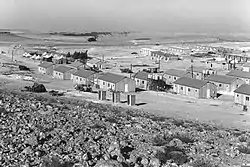
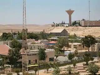 View of the town
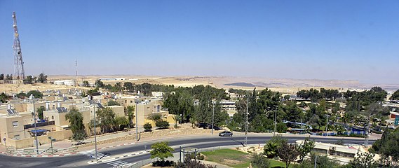 Panorama of Mitzpe Ramon
References
- "Population in the Localities 2019" (XLS). Israel Central Bureau of Statistics. Retrieved 16 August 2020.
- The list said go to Batumi and Eilat but I got other ideas, New York Times
- http://jpress.org.il/Olive/APA/NLI_Heb/SharedView.Article.aspx?parm=JWg%2BxkVblgwkrxBOOQgWJpIn2SodyNClPUSG%2FcFX69q2nQiY4QpArrHmXA4cVYHqYw%3D%3D&mode=image&href=DAV%2f1961%2f06%2f16&page=13&rtl=true
- Makhteshim Country, UNESCO
- "Averages and Records for Tel Aviv (Precipitation, Temperature and Records written in the page)". Israel Meteorological Service. Retrieved 1 August 2010.(in Hebrew)
- "Extremes for Tel Aviv [Records of February and May]". Israel Meteorological Service. Retrieved 2 August 2015.(in Hebrew)
- "Temperature average". Israel Meteorological Service. Retrieved 8 December 2011.(in Hebrew)
- "Precipitation average". Retrieved 12 July 2011.(in Hebrew)
- Supplying the world with Jerusalem stone
- Israel's Grand Canyon Town Struggles to Shake Off Sand, Haaretz
- Vegas in the Negev?
- http://www.meeverland.com/
- Azoulay, Yuval. "Mitzpeh Ramon's Embattled Mayor Pins Hopes on Interior Ministry". Haaretz. Retrieved 2008-10-25.
External links
 Mitzpe Ramon travel guide from Wikivoyage
- Mitzpe Ramon Local Council (Hebrew)
- Mitzpe Ramon High resolution virtual tours of the crater (English)
- Astronomy Israel (English)
| Cities | ||
|---|---|---|
| Local councils | ||
| Regional councils | ||
| See also | ||
| ||