Meitar
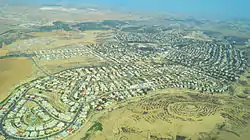
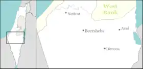
Meitar (Hebrew: מֵיתָר) is a small local council north-east of Beersheba, in Israel's Southern District. The town lies on Highway 60 just south of the Green Line on the southern edge of Mount Hebron, alongside the Yatir Forest. Metar is 19 km north of Beer-Sheva and is in between the two Bedouin towns of Hura and Laqiya. In 2019 it had a population of 9,418.[1]
Meitar
מֵיתָר | |
|---|---|
Local council (from 1987) | |
| Hebrew transcription(s) | |
| • ISO 259 | Meitar |
| • Also spelled | Metar (official) |
 | |
 Meitar | |
| Coordinates: 31°19′38.15″N 34°56′18.78″E | |
| District | Southern |
| Founded | 1984 |
| Government | |
| • Head of Municipality | Shimon Mazuz |
| Area | |
| • Total | 16,696 dunams (16.696 km2 or 6.446 sq mi) |
| Population (2019)[1] | |
| • Total | 9,418 |
| • Density | 560/km2 (1,500/sq mi) |
| Name meaning | string (of a tent, reflected in logo) |
With a land area of 16,696 dunams (~16.7 km²), Meitar is ranked very highly on the Israeli socio-economic scale, with a score of 9/10.[2]
History
Meitar was founded in 1984. The area drew national attention during the Shai Dromi trial.
References
- "Population in the Localities 2019" (XLS). Israel Central Bureau of Statistics. Retrieved 16 August 2020.
- "Local Authorities in Israel 2005, Publication #1295 - Municipality Profiles - Meitar" (PDF) (in Hebrew). Israel Central Bureau of Statistics. Retrieved 2008-03-07.
External links
- Psagot elementary school in Meitar
- Amit elementary school in Meitar
- Meitarim High school in Meitar
- Metar Sports Club
| Cities | ||
|---|---|---|
| Local councils | ||
| Regional councils | ||
| See also | ||
| ||
This article is issued from Wikipedia. The text is licensed under Creative Commons - Attribution - Sharealike. Additional terms may apply for the media files.
