Negev
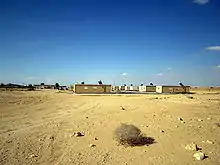
The Negev or Negeb (/ˈnɛɡɛv/; Hebrew: הַנֶּגֶב; Arabic: ٱلنَّقَب an-Naqab) is a desert and semidesert region of southern Israel. The region's largest city and administrative capital is Beersheba (pop. 209,687), in the north. At its southern end is the Gulf of Aqaba and the resort city of Eilat. It contains several development towns, including Dimona, Arad and Mitzpe Ramon, as well as a number of small Bedouin towns, including Rahat and Tel as-Sabi and Lakyah. There are also several kibbutzim, including Revivim and Sde Boker; the latter became the home of Israel's first Prime Minister, David Ben-Gurion, after his retirement from politics.
Although historically part of a separate region (known in Roman times as Arabia Petraea), the Negev was added to the proposed area of Mandatory Palestine, of which large parts later became Israel, on 10 July 1922, having been conceded by British representative St John Philby "in Trans-Jordan's name".[lower-alpha 1] Despite this, the region remained exclusively Arab until 1946; in response to the British Morrison–Grady Plan which would have allotted the area to an Arab state, the Jewish Agency enacted the 11 points in the Negev plan to begin Jewish settlement in the area.[2][3] Within a year, the United Nations Partition Plan for Palestine allotted the area to the Jewish State, later Israel.
The desert is home to the Ben-Gurion University of the Negev, whose faculties include the Jacob Blaustein Institutes for Desert Research and the Albert Katz International School for Desert Studies, both located on the Midreshet Ben-Gurion campus adjacent to Sde Boker.
In October 2012, global travel guide publisher Lonely Planet rated the Negev second on a list of the world's top ten regional travel destinations for 2013, noting its current transformation through development.[4][5]
Etymology and other names
The origin of the word 'negev' is from the Hebrew root denoting 'dry'. In the Hebrew Bible, the word Negev is also used for the direction 'south'; some English-language translations use the spelling "Negeb".
The Negev mentioned in the Bible consisted only of the northernmost part of the modern Israeli Negev with, the semiarid Arad-Beersheba Valley defined as "the eastern (biblical) Negev".[6]
In Arabic, the Negev is known as al-Naqab or an-Naqb ("the [mountain] pass"),[7][8] though it was not thought of as a distinct region until the demarcation of the Egypt-Ottoman frontier in the 1890s and has no traditional Arabic name.[9]
During the British Mandate, it was called Beersheba sub-district.[9]
Geography
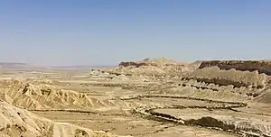
The Negev covers more than half of Israel, over some 13,000 km2 (4,700 sq mi) or at least 55% of the country's land area. It forms an inverted triangle shape whose western side is contiguous with the desert of the Sinai Peninsula, and whose eastern border is the Arabah valley. The Negev has a number of interesting cultural and geological features. Among the latter are three enormous, craterlike makhteshim (box canyons), which are unique to the region: Makhtesh Ramon, HaMakhtesh HaGadol, and HaMakhtesh HaKatan.
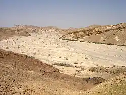
The Negev is a rocky desert. It is a melange of brown, rocky, dusty mountains interrupted by wadis (dry riverbeds that bloom briefly after rain) and deep craters. It can be split into five different ecological regions: northern, western and central Negev, the high plateau and the Arabah Valley. The northern Negev, or Mediterranean zone, receives 300 mm of rain annually and has fairly fertile soils. The western Negev receives 250 mm of rain per year, with light and partially sandy soils. Sand dunes can reach heights of up to 30 metres here. Home to the city of Beersheba, the central Negev has an annual precipitation of 200 mm and is characterized by impervious soil, known as loess, allowing minimum penetration of water with greater soil erosion and water runoff. The high plateau area of Negev Mountains/Ramat HaNegev (Hebrew: רמת הנגב, The Negev Heights) stands between 370 metres and 520 metres above sea level with extreme temperatures in summer and winter. The area gets 100 mm of rain per year, with inferior and partially salty soils. The Arabah Valley along the Jordanian border stretches 180 km from Eilat in the south to the tip of the Dead Sea in the north. The Arabah Valley is very arid with barely 50 mm of rain annually. It has inferior soils in which little can grow without irrigation and special soil additives.
Flora and fauna
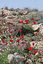
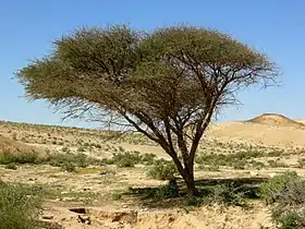
Vegetation in the Negev is sparse, but certain trees and plants thrive there, among them Acacia, Pistacia, Retama, Urginea maritima and Thymelaea.[10] Hyphaene thebaica or doum palm can be found in the Southern Negev. The Evrona Nature Reserve is the most northerly point in the world where this palm can be found.
A small population of Arabian leopards, an endangered animal in the Arabian peninsula, survives in the southern Negev.[11] Other carnivora found in the Negev are the caracal, the Arabian wolf, the golden jackal and the marbled polecat.[12]
The Arabah mountain gazelle, a subspecies of the mountain gazelle, survives with a few individuals in the Negev. The dorcas gazelle is more numerous with some 1,000–1,500 individuals in the Negev.[12] Some 350 to 500 Nubian ibex live in the Negev Highlands and in the Eilat Mountains.[13]
The Negev shrew (Crocidura ramona) is a species of mammal of the family Soricidae found only in Israel.[14] The Negev tortoise (Testudo werneri) is a critically endangered species that currently lives only in the sands of the western and central Negev Desert.[15]
Animals that were reintroduced after extinction in the wild or local extinction respectively are the Arabian oryx and the Persian fallow deer. The Negev is the only place where reintroduced Arabian oryx flourish because nowhere else in the Middle East poaching can be controlled.[12] Also introduced was the Asiatic wild ass which in the Negev counts about 250 animals.[16]
Climate
The Negev region is arid (Eilat receives on average only 24 mm of rainfall a year), receiving very little rain due to its location to the east of the Sahara (as opposed to the Mediterranean which lies to the west of Israel), and extreme temperatures due to its location 31 degrees north. However the northernmost areas of the Negev, including Beersheba, are semi-arid. The usual rainfall total from June through October is zero. Snow and frost are rare in the northern Negev, and snow and frost are unknown in the vicinity of Eilat in the southernmost Negev.[17]
| Climate data for Beersheba | |||||||||||||
|---|---|---|---|---|---|---|---|---|---|---|---|---|---|
| Month | Jan | Feb | Mar | Apr | May | Jun | Jul | Aug | Sep | Oct | Nov | Dec | Year |
| Record high °C (°F) | 28.4 (83.1) |
31 (88) |
35.4 (95.7) |
40.9 (105.6) |
42.2 (108.0) |
46 (115) |
41.5 (106.7) |
40.5 (104.9) |
41.2 (106.2) |
39.6 (103.3) |
34 (93) |
31.4 (88.5) |
46 (115) |
| Average high °C (°F) | 16.7 (62.1) |
17.5 (63.5) |
20.1 (68.2) |
25.8 (78.4) |
29 (84) |
31.3 (88.3) |
32.7 (90.9) |
32.8 (91.0) |
31.3 (88.3) |
28.5 (83.3) |
23.5 (74.3) |
18.8 (65.8) |
25.7 (78.3) |
| Average low °C (°F) | 7.5 (45.5) |
7.6 (45.7) |
9.3 (48.7) |
12.7 (54.9) |
15.4 (59.7) |
18.4 (65.1) |
20.5 (68.9) |
20.9 (69.6) |
19.5 (67.1) |
16.7 (62.1) |
12.6 (54.7) |
8.9 (48.0) |
14.2 (57.6) |
| Record low °C (°F) | −5 (23) |
−0.5 (31.1) |
2.4 (36.3) |
4 (39) |
8 (46) |
13.6 (56.5) |
15.8 (60.4) |
15.6 (60.1) |
13 (55) |
10.2 (50.4) |
3.4 (38.1) |
3 (37) |
−5 (23) |
| Average precipitation mm (inches) | 49.6 (1.95) |
40.4 (1.59) |
30.7 (1.21) |
12.9 (0.51) |
2.7 (0.11) |
0 (0) |
0 (0) |
0 (0) |
0.4 (0.02) |
5.8 (0.23) |
19.7 (0.78) |
41.9 (1.65) |
204.1 (8.04) |
| Average precipitation days | 9.2 | 8 | 6.4 | 2.6 | 0.8 | 0 | 0 | 0 | 0.1 | 1.8 | 4.6 | 7.5 | 41 |
| Source: Israel Meteorological Service[18][19] | |||||||||||||
| Climate data for Eilat | |||||||||||||
|---|---|---|---|---|---|---|---|---|---|---|---|---|---|
| Month | Jan | Feb | Mar | Apr | May | Jun | Jul | Aug | Sep | Oct | Nov | Dec | Year |
| Record high °C (°F) | 32.2 (90.0) |
35.8 (96.4) |
38.7 (101.7) |
43.4 (110.1) |
45.2 (113.4) |
47.4 (117.3) |
48.3 (118.9) |
48.0 (118.4) |
45.0 (113.0) |
44.3 (111.7) |
38.1 (100.6) |
33.6 (92.5) |
48.3 (118.9) |
| Average high °C (°F) | 21.3 (70.3) |
23.0 (73.4) |
26.1 (79.0) |
31.0 (87.8) |
35.7 (96.3) |
38.9 (102.0) |
40.4 (104.7) |
40.0 (104.0) |
37.3 (99.1) |
33.1 (91.6) |
27.7 (81.9) |
23.0 (73.4) |
31.5 (88.6) |
| Average low °C (°F) | 10.4 (50.7) |
11.8 (53.2) |
14.6 (58.3) |
18.4 (65.1) |
22.5 (72.5) |
25.2 (77.4) |
27.3 (81.1) |
27.4 (81.3) |
25.2 (77.4) |
21.8 (71.2) |
16.3 (61.3) |
11.9 (53.4) |
19.4 (66.9) |
| Record low °C (°F) | 1.2 (34.2) |
0.9 (33.6) |
3.0 (37.4) |
8.4 (47.1) |
12.1 (53.8) |
18.5 (65.3) |
20.0 (68.0) |
19.4 (66.9) |
18.6 (65.5) |
9.2 (48.6) |
5.3 (41.5) |
2.5 (36.5) |
0.9 (33.6) |
| Average rainfall mm (inches) | 4 (0.2) |
3 (0.1) |
3 (0.1) |
2 (0.1) |
1 (0.0) |
0 (0) |
0 (0) |
0 (0) |
0 (0) |
4 (0.2) |
2 (0.1) |
5 (0.2) |
24 (1) |
| Average rainy days (≥ 0.1 mm) | 2.1 | 1.8 | 1.6 | 0.9 | 0.7 | 0 | 0 | 0 | 0 | 0.7 | 0.8 | 1.9 | 10.5 |
| Source: Israel Meteorological Service[20][21][22][23] | |||||||||||||
History
Prehistorical nomads
Nomadic life in the Negev dates back at least 4,000 years[24] and perhaps as much as 7,000 years.[25]
Bronze Age
The first urbanized settlements were established by a combination of Canaanite, Amalekite, Amorite, Nabataean and Edomite groups circa 2000 BCE.[24] Pharaonic Egypt is credited with introducing copper mining and smelting in both the Negev and the Sinai between 1400 and 1300 BCE.[24][26]
Extent of biblical Negev
According to Israeli archaeologists, in the Hebrew Bible, the term Negev only relates to the northern, semiarid part of what we call Negev today; of this, the Arad-Beersheba Valley, which receives enough rain as to allow agriculture and thus sedentary occupation (the "desert fringe"), is accordingly defined as "the eastern (biblical) Negev".[6]
Biblical reference
According to the Book of Genesis chapter 13, Abraham lived for a while in the Negev after being banished from Egypt (Genesis 13:1,3). During the Exodus journey to the Promised Land, Moses sent twelve scouts into the Negev to assess the land and population (Numbers 13:17). Later the northern part of biblical Negev was inhabited by the Tribe of Judah and the southern part of biblical Negev by the Tribe of Simeon. The Negev was later part of the Kingdom of Solomon (in its entirety, all the way to the Red Sea), and then, with varied extension to the south, part of the Kingdom of Judah.[27]
Iron Age
In the 9th century BCE, development and expansion of mining in both the Negev and Edom (modern Jordan) coincided with the rise of the Assyrian Empire.[24] Beersheba was the region's capital and a center for trade in the 8th century BCE.[24] Small settlements of Israelites in the areas around the capital existed between 1020 and 928 BCE.[24]
Nabateans and Romans
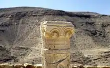
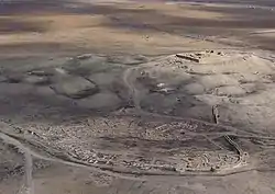
The 4th century BCE arrival of the Nabateans resulted in the development of irrigation systems that supported new urban centers located along the Negev incense route at Avdat, Mamshit, Shivta, Haluza (Elusa), and Nitzana.[24] The Nabateans controlled the trade on the spice route between their capital Petra and the Gazan seaports. Nabatean currency and the remains of red and orange potsherds, identified as a trademark of their civilization, have been found along the route, remnants of which are also still visible.[24] Nabatean control of the Negev ended when the Roman empire annexed their lands in 106 CE.[24] The population, largely made up of nomads, although under Roman rule, venerated deities such as Dushara, Allat, and others.[24]
Byzantines
Byzantine rule in the 4th century introduced Christianity to the population.[24] Agricultural-based cities were established and the population grew exponentially.[24]
In January 2021, archaeologists from Israel Antiquities Authority announced the discovery of tombstone dating back 1,400 years with Greek inscription by an employee of the Parks and Nature Authority at Nitzana National Park. On the Christian woman's stone named Maria these words were written: ‘Blessed Maria who lived immaculate life’.[28][29][30]
Early-mid Islamic empires
The southern Negev saw a flourishing of economic activity during the 8th to 10th or 11th centuries.[31] Six Islamic settlements have been found in the vicinity of modern Eilat, along with copper and gold mines and stone quarries, and a sophisticated irrigation system and road network.[31] The economic center was the port of Ayla (Aqaba).[31]
10th–19th century Bedouins
Nomadic tribes ruled the Negev largely independently and with a relative lack of interference for the next thousand years.[24] What is known of this time is largely derived from oral histories and folk tales of tribes from the Wadi Musa and Petra areas in present-day Jordan.[24] The Bedouins of the Negev historically survived chiefly on sheep and goat husbandry. Scarcity of water and of permanent pastoral land required them to move constantly. The Bedouin in years past established few permanent settlements, although some were built, leaving behind remnants of stone houses called 'baika.'[25]
Late Ottoman period (1900–1917)
In 1900 the Ottoman Empire established an administrative center for southern Syria at Beersheba including schools and a railway station.[24] The authority of the tribal chiefs over the region was recognized by the Ottomans.[24] A railroad connected it to the port of Rafah. In 1914 the Turkish authorities estimated the nomadic population at 55,000.[32]
British Mandate
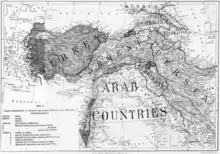
The 1916 Sykes-Picot Agreement between Britain and France placed the Negev in Area B, "Arab state or states" under British patronage.[34] The Negev was taken from the Ottoman army by British forces during 1917 and became part of Mandatory Palestine.
In 1922, the Bedouin component of the population was estimated at 72,898 out of a total of 75,254 for the Beersheba sub-district.[32] The 1931 census estimated that the population of the Beersheba sub-district was 51,082.[35] This large decrease was considered to be an artifact of incorrect enumeration methods used in 1922.[32] An Arabic history of tribes around Beersheba, published in 1934 records 23 tribal groups.[36]
State of Israel
Most of the Negev was earmarked by the November 1947 UN Partition Plan for the future Jewish state. During the 1947–49 War of Independence, Israel secured its sovereignty over the Negev. In the early years of the state, it absorbed many of the Jewish refugees from Arab countries, with the Israeli government setting up many development towns, such as Arad, Sderot and Netivot. Since then, the Negev has also become home to many of the Israel Defense Forces' major bases – a process accelerating in the past two decades.
Demography
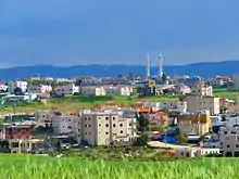
As of 2010, the Negev was home to some 630,000 people (or 8.2% of Israel's population), even though it comprises over 55% of the country's area. 470,000 Negev residents or 75% of the population of the Negev are Jews, while 160,000 or 25% are Bedouin.[37] Of the Bedouin population (a demographic with a semi-nomadic tradition), half live in unrecognized villages, and half live in towns built for them by the Israeli government between the 1960s and 1980s; the largest of these is Rahat.
The population of the Negev is expected to reach 1.2 million by 2025. It has been projected that the Beersheba metropolitan area will reach a population of 1 million by 2020, and Arad, Yeruham, and Dimona will triple in size by 2025.[38][39]
Bedouin
A large part of the Negev Bedouins inhabit small communities or villages. Since Israel's conquest in the 1948 Arab-Israeli War, Israel has refused to recognize dozens of Bedouin villages, and Bedouins are denied the right to have land in the Negev. The habitat and authentic existence of 195,000 Bedouins are currently under threat of destruction. Under Israel's 2011-adopted and enacted Begin-Prawer plan - officially Bill on the Arrangement of Bedouin Settlement in the Negev - the Bedouins are being moved to newly created townships while dozens of original Bedouin villages have been declared illegal. They are consequently destroyed or threatened with destruction.[40][41] An Israeli court ruling in 2017 forced six residents to pay the cost of eight rounds of demolition to the state.[42]
Economy and housing
Development plans
Blueprint Negev is a Jewish National Fund project introduced in 2005. The $600 million project hopes to attract 500,000 new Jewish residents to the Negev by improving transportation infrastructure, establishing businesses, developing water resources and introducing programs to protect the environment.[43] A planned artificial desert river, swimming pools and golf courses raised concerns among environmentalists.[44][45] Critics oppose those plans, calling instead for an inclusive plan for the green vitalization of existing population centers, investment in Bedouin villages, clean-up of toxic industries and development of job options for the unemployed.[46][47][48] [49]
A major Israel Defense Forces training base is being constructed in the Negev to accommodate 10,000 army personnel and 2,500 civilian staff. Three more bases will be built by 2020 as part of a plan to vacate land and buildings in Tel Aviv and central Israel, and bring jobs and investment to the south.[50]
Solar power
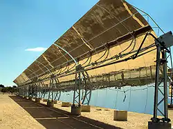
The Negev Desert and the surrounding area, including the Arava Valley, are the sunniest parts of Israel and little of this land is arable, which is why it has become the center of the Israeli solar industry.[51] David Faiman, an expert on solar energy, feels the energy needs of Israel's future could be met by building solar energy plants in the Negev. As director of Ben-Gurion National Solar Energy Center, he operates one of the largest solar dishes in the world.[52] Technically, however, the Arava is a separate desert with its own unique climate and ecology.
A 250 MW solar park in Ashalim, an area in the northern Negev, the Ashalim Power Station, produces 121 Megawatts of power, using solar mirrors and thermal water heating. It is currently the largest in Israel.
The Rotem Industrial Complex outside of Dimona, Israel, has dozens of solar mirrors that focus the Sun's rays on a tower that in turn heats a water boiler to create steam, turning a turbine to create electricity. Luz II, Ltd., plans to use the solar array to test new technology for the three new solar plants to be built in California for Pacific Gas and Electric Company.[53][54][55]
Wineries

Vines have been planted in the Negev since ancient times. In modern times, vineyards have been established in the northern Negev hills using innovative computerized watering methods for irrigation. Carmel Winery was the first of the major wineries to plant vineyards in the Negev and operates a boutique winery at Ramat Arad. Tishbi has vineyards at Sde Boker and Barkan grows its grapes in Mitzpe Ramon.[56] Yatir Winery is a winery in Tel Arad. Its vineyards are on a hill 900 meters above sea level on the outskirts of Yatir Forest.[57] Carmey Avdat is Israel's first solar-powered winery.[58]
Environmental issues
The Negev is home to hazardous infrastructures that include Negev Nuclear Research Center nuclear reactor, 22 agrochemical and petrochemical factories, an oil terminal, closed military zones, quarries, a toxic waste incinerator at Ne'ot Hovav, cell towers, a power plant, several airports, a prison, and 2 rivers of open sewage.[59]
In 2005, the Tel Aviv municipality was accused of dumping waste in the Negev at the Dudaim dump.[60] The Manufacturers Association of Israel established an authority in 2005 to move 60 industrial enterprises active in the Tel Aviv region to the Negev.[61]
In 1979, the Ramat Hovav toxic waste facility was established in Wadi el-Na'am because the area was perceived as invulnerable to leakage. However, within a decade, cracks were found in the rock beneath Ramat Hovav.[59] In 2004, the Israeli Ministry of Health released Ben Gurion University research findings describing the health problems in a 20 km vicinity of Ramat Hovav. The study, funded in large part by Ramat Hovav, found higher rates of cancer and mortality for the 350,000 people in the area. Prematurely released to the media by an unknown source, the preliminary study was publicly discredited;[62] However, its final conclusions – that Bedouin and Jewish residents near Ramat Hovav are significantly more susceptible than the rest of the population to miscarriages, severe birth defects, and respiratory diseases – passed a peer review several months later.[63]
See also
References
- Biger 2004, p. 181; Biger references 10 July 1922 meeting notes, file 2.179, CZA.
- Karsh, Efraim; Miller, Rory (23 October 2013). Israel at Sixty: Rethinking the Birth of the Jewish State. Routledge. pp. 55–. ISBN 978-1-317-96776-7.
- Pappé, Ilan (15 August 1994). The Making of the Arab-Israeli Conflict, 1947–1951. I.B.Tauris. pp. 52–. ISBN 978-1-85043-819-9.
- Gattegno, Ilan (October 26, 2012). "Negev named among top ten travel destinations for 2013". Israel Hayom. Archived from the original on October 6, 2014. Retrieved October 29, 2012.
- "Best in Travel 2013 – Top 10 regions". Lonely Planet. October 23, 2012. Archived from the original on March 9, 2013. Retrieved April 2, 2013.
- Beit-Arieh, Itzhaq (1999). "Introduction: Settlement in the Eastern Negev". Tel Ira: a stronghold in the biblical Negev. The Emery and Clare Yass Publications in Archaeology: Monograph Series of the Institute of Archaeology. Tel Aviv: Tel Aviv University. ISBN 965-440-008-1. Archived from the original on 9 July 2019. Retrieved 9 July 2019.
- Sharon, Moshe (1997). 'Aqabah (Ailah). Corpus Inscriptionum Arabicarum Palaestinae. Handbook of Oriental Studies/Handbuch Der Orientalistik. Leiden & Boston: Brill Academic Publishers. pp. 89–90. ISBN 9789004108332. Archived from the original on 23 November 2015. Retrieved 1 May 2015.
In fact, there are two mountain passes through which the road of Aylah has to cross. The western one crosses the mountain ridge to the west of the gulf, and through it passes the main road from Egypt which cuts through the whole width of Sinai, coming from Cairo via Suez. This mountain pass is also called 'Aqabat Aylah, or as it is better known, "Naqb al-'Aqabah" or "Ras an-Naqb."
- Hertzog, Esther; Abuhav, Orit; Goldberg, Harvey E.; Marx, Emanuel (8 May 2018). Perspectives on Israeli Anthropology. Wayne State University Press. ISBN 978-0814330500. Archived from the original on 26 March 2016. Retrieved 8 May 2018 – via Google Books.
- Palestine Exploration Quarterly (April 1941). The Negev, or Southern Desert of Palestine by George E. Kirk. London. Page 57.
- Bailey, C.; Danin, A. (1981). "Bedouin plant utilization in Sinai and the Negev". Economic Botany. 35 (2): 145. doi:10.1007/BF02858682. S2CID 27839209.
- "Gulf-Environment: Arabian Leopard Faces Extinction". highbeam.com. Archived from the original on 5 May 2016. Retrieved 8 May 2018.
- "Israel's Unique Wildlife" at the Davidson Institute.
- "Nubian Ibex" at natureisrael.org.
- "Crocidura ramona (Negev Shrew)". IUCN Red List of Threatened Species. Retrieved 8 May 2018.
- "Re-introduction – Negev tortoise". jerusalemzoo.org.il. Archived from the original on 15 December 2013. Retrieved 8 May 2018.
- "Asiatic wild ass" at iucnredlist.org.
- "Beersheba, ISR Weather". MSN. Archived from the original on 2007-11-17. Retrieved 2008-01-25.
- "Averages and Records for Beersheba (Precipitation, Temperature and Records [Excluding January and June] written in the page)". Israel Meteorological Service. August 2011. Archived from the original on 2010-09-14.
- "Records Data for Israel (Data used only for January and June)". Israel Meteorological Service. Archived from the original on 2011-08-23.
- "Averages and Records for Tel Aviv (Precipitation, Temperature and Records written in the page)". Israel Meteorological Service. Archived from the original on 14 September 2010. Retrieved 1 August 2010.(in Hebrew)
- "Extremes for Tel Aviv [Records of February and May]". Israel Meteorological Service. Archived from the original on 10 July 2015. Retrieved 2 August 2015.(in Hebrew)
- "Temperature average". Israel Meteorological Service. Archived from the original on 18 June 2013. Retrieved 8 December 2011.(in Hebrew)
- "Precipitation average". Archived from the original on 25 September 2011. Retrieved 12 July 2011.(in Hebrew)
- Mariam Shahin. Palestine: A Guide. (2005) Interlink Books. ISBN 1-56656-557-X
- Israel Finkelstein; Avi Perevolotsky (Aug 1990). "Processes of Sedentarization and Nomadization in the History of Sinai and the Negev". Bulletin of the American Schools of Oriental Research (279): 67–88.CS1 maint: multiple names: authors list (link)
- J. M. Tebes (2008). "Centro y periferia en el mundo antiguo. El Negev y sus interacciones con Egipto, Asiria, y el Levante en la Edad del Hierro (1200-586 A.D.) ANEM 1. SBL – CEHAO" (PDF). uca.edu.ar.
- Evenari, Michael; Shanan, Leslie; Tadmor, Naphtali (8 May 1982). The Negev: The Challenge of a Desert. Harvard University Press. p. 18. ISBN 9780674606722. Retrieved 8 May 2018 – via Internet Archive.
- staff, T. O. I. "'Blessed Maria who lived immaculate life': Ancient tombstone found at Negev park". www.timesofisrael.com. Retrieved 2021-01-22.
- "Archaeologists find Byzantine tombstone inscribed 'Blessed Maria' in Israel". Haaretz.com. Retrieved 2021-01-22.
- Gershon, Livia. "A Tombstone Inscribed in Ancient Greek Is Found in Southern Israel". Smithsonian Magazine. Retrieved 2021-01-22.
- Uzi Avner and Jodi Magness (1998). "Early Islamic settlement in the Southern Negev". Bulletin of the American Schools of Oriental Research. 310 (310): 39–57. doi:10.2307/1357577. JSTOR 1357577. S2CID 163609232.
- Palestine, Report and General Abstracts of the Census of 1922, October 1922, J.B. Barron, Superintendent of the Census, pages 4,7
- Map from CAB 24/72/7 Archived 2016-11-07 at the Wayback Machine: "Maps illustrating the Settlement of Turkey and the Arabian Peninsula", forming an annex to: CAB 24/72/6 Archived 2016-11-07 at the Wayback Machine, a British Cabinet memorandum on "The Settlement of Turkey and the Arablan Peninsula"
- Biger, Gideon (2004). The Boundaries of Modem Palestine, 1840–1947. RoutledgeCurzon. p. 64.
- Census of Palestine 1931, Volume I. Palestine Part I, Report. Alexandria, 1933, p49.
- Palestine Exploration Quarterly. (October 1937 & January 1938) Notes on the Bedouin Tribes of Beersheba District. by S. Hillelson. Translations from A History of Beersheba and the Tribes thereof (Ta'rikh Bir al-Saba' wa qaba'iliha). by 'Arif al-'Arif.
- "A Bedouin welcome – Israel Travel, Ynetnews". Ynetnews.com. 1995-06-20. Archived from the original on 2011-06-29. Retrieved 2011-10-09.
- Udasin, Sharon. "'1.2 million residents in the Negev by 2025' | JPost | Israel News". JPost. Archived from the original on 2012-09-30. Retrieved 2014-01-19.
- "תוכנית באר שבע אושרה; המטרה – מיליון תושבים עד שנת 2020". Calcalist.co.il. 1995-06-20. Archived from the original on 2014-02-03. Retrieved 2014-01-19.
- Prawer Plan: How the natives became invaders in their own homes 972mag, 5 december 2013
- Bedouin's plight: 'We want to maintain our traditions. But it's a dream here' The Guardian, 3 November 2011
- Israeli Court Orders Bedouin to Reimburse State for Cost of Demolishing Their Homes."...six residents of al-Araqib must pay 262,000 shekels (more than $72,000) for previous demolition costs, in addition to 100,000 shekels ($27,693) to cover the costs of the state’s lawyer." Haaretz, 22 August 2017
- http://www.jnf.org/site/PageServer?pagename=negevPoints Archived August 13, 2007, at the Wayback Machine
- Orenstein, Daniel (March 25, 2007). "When an ecological community is not". haaretz.com. Archived from the original on September 25, 2009.
- Archived April 2, 2015, at the Wayback Machine
- Orenstein, Daniel; Hamburg, Steven (November 28, 2005). "The JNF's Assault on the Negev". The Jerusalem Report. watsoninstitute.org. Archived from the original on October 19, 2007. Retrieved August 7, 2008.
- "Ohalah resolution". neohasid.org. Archived from the original on 2013-07-02.
- "Neohasid's Save the Negev Campaign". neohasid.org. Archived from the original on 2013-12-15.
- Manski, Rebecca (9 November 2010). "Blueprint Negev". MERIP/Mondoweiss. Archived from the original on 15 August 2014. Retrieved 23 January 2015.
- "Subscribe to read". Financial Times. Archived from the original on 20 August 2016. Retrieved 8 May 2018. Cite uses generic title (help)
- Ehud Zion Waldoks (March 10, 2008). "Head of Kibbutz Movement: We will not be discriminated against by the government". Jerusalem Post. Archived from the original on July 13, 2011. Retrieved February 4, 2011.
- Lettice, John (January 25, 2008). "Giant solar plants in Negev could power Israel's future". The Register. Archived from the original on September 29, 2013.
- "Calif. solar power test begins — in Israeli desert". Associated Press. June 12, 2008. Retrieved December 23, 2008.
- Rabinovitch, Ari (June 11, 2008). "Israel site for California solar power test". Reuters.
- Washington (2008-05-08). "Building Small Prototype Homes, an Israeli Solar Experiment | News | English". Voanews.com. Archived from the original on 2009-08-26. Retrieved 2011-10-09.
- Israel's Wine Regions Archived 2012-03-05 at the Wayback Machine
- Rogov, Daniel (2009). Rogov's Guide to Israeli Wine. London, England: Toby Press. p. 467. ISBN 978-1613290194.
- "Sunday Energy and Carmey Avdat Winery Helping Produce Israel's First Solar Powered Wine". greenprophet.com. Archived from the original on 25 March 2017. Retrieved 8 May 2018.
- Manski, Rebecca. "Bedouin Vilified Among Top 10 Environmental Hazards in Israel". AIC. Archived from the original on 5 December 2013. Retrieved 12 April 2013.
- Berger, Gali (October 12, 2005). "Sin of waste / Municipal garbage that's out of sight, out of mind". Haaretz. boker.org.il. Archived from the original on June 9, 2011. Retrieved July 29, 2008.
- Manor, Hadas (August 11, 2005). "Manufacturers promoting transfer of 60 factories to Negev". Globes. boker.org.il. Archived from the original on November 22, 2005. Retrieved July 29, 2008.
- Manski, Rebecca (2005). "The Bedouin as Worker-Nomad". bustan.org. Archived from the original on 2011-10-03.
- Sarov, Batia, and peers at Ben Gurion University: "Major congenital malformations and residential proximity to a regional industrial park including a national toxic waste site: An ecological study;" Environmental Health: A Global Access Science Source 2006, 5:8; Bentov et al., licensee BioMed Central Ltd.
Notes
- Biger described this meeting as follows: "Sovereignty over the Arava, from the south of the Dead Sea to Aqaba, was also discussed. Philby agreed, in Trans-Jordan's name, to give up the western bank of Wadi Arava (and thus all of the Negev area). Nevertheless, a precise borderline was still not determined along the territories of Palestine and Trans-Jordan. Philby's relinquishment of the Negev was necessary, because the future of this area was uncertain. In a discussion regarding the southern boundary, the Egyptian aspiration to acquire the Negev area was presented. On the other hand the southern part of Palestine belonged, according to one of the versions, to the sanjak (district) of Ma'an within the vilayet (province) of Hejaz. King Hussein of Hijaz demanded to receive this area after claiming that a transfer action, to add it to the vilayet of Syria (A-Sham) was supposed to be done in 1908. It is not clear whether this action was completed. Philby claimed that Emir Abdullah had his father's permission to negotiate over the future of the sanjak of Ma'an, which was actually ruled by him, and that he could therefore 'afford to concede' the area west of the Arava in favour of Palestine. This concession was made following British pressure and against the background of the demands of the Zionist Organization for direct contact between Palestine and the Red Sea. It led to the inclusion of the Negev triangle in Palestine's territory, although this area was not considered as part of the country in the many centuries that preceded the British occupation."[1]
Bibliography
- Biger, Gideon (2004). The Boundaries of Modern Palestine, 1840–1947. Routledge. ISBN 978-1-135-76652-8.
External links
| Wikimedia Commons has media related to Negev. |
| Wikivoyage has a travel guide for Negev. |
| Cities | ||
|---|---|---|
| Local councils | ||
| Regional councils | ||
| See also | ||
| ||