Mondure
Mondure is a rural town and locality in the South Burnett Region, Queensland, Australia.[2][3] In the 2016 census, Mondure had a population of 100 people.[1]
| Mondure Queensland | |||||||||||||||
|---|---|---|---|---|---|---|---|---|---|---|---|---|---|---|---|
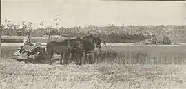 Reaping the wheat, Keleher brothers farm, North Mondure, 1919 | |||||||||||||||
 Mondure | |||||||||||||||
| Coordinates | 26.1803°S 151.7735°E | ||||||||||||||
| Population | 100 (2016 census)[1] | ||||||||||||||
| • Density | 4.2/km2 (11/sq mi) | ||||||||||||||
| Established | 1844 | ||||||||||||||
| Postcode(s) | 4611 | ||||||||||||||
| Area | 23.8 km2 (9.2 sq mi) | ||||||||||||||
| Time zone | AEST (UTC+10:00) | ||||||||||||||
| Location | |||||||||||||||
| LGA(s) | South Burnett Region | ||||||||||||||
| State electorate(s) | Nanango | ||||||||||||||
| Federal Division(s) | Flynn | ||||||||||||||
| |||||||||||||||
History
The town takes its name from the Mondrure pastoral run taken up in 1844 by Richard Jones, which used a Waka language word, mondhur meaning small ant.[2]
Land was open for selection on 17 April 1877; 68 square miles (180 km2) were available in Mondure and 56 square miles (150 km2) in Mondure back run.[4]
Circa 1900s, 78 farming blocks in the Mondure Estate were advertised to be sold. The map advertisement states that the blocks were 6 miles from Wondai railway station and 4 miles from Murgon railway station.[5]
Mondure North Provisional School opened in January 1905. On 1 Jan 1909 it became Mondure North State School. It closed in October 1922.[6]
On Saturday 11 March 1911, 120 town lots were auctioned in the Township of Mondure.[7]
On 23 February 1917 the Queensland Railways Department decided to call the town's railway station Kooblinga but this was changed on 11 January 1918 to be Mondure at the request of the Mondure Branch of the Queensland Farmers Union .[2]
St Faith's Anglican Church was dedicated in 1917.[8]
Mondure Township State School opened on 24 January 1921. In 1938 it was renamed Mondure State School. It closed on 31 December 1998.[6]
In the 2016 census, Mondure had a population of 100 people.[1]
Education
There are no schools in Mondure. The nearest primary school (Prep-6) is Wheatlands State School in Wheatlands to the east. The nearest secondary schooling is available at Wondai State School (to Year 9) in Wondai to the south, Proston State School (to Year 10) in Proston to the west, and Murgon State High School (to Year 12) in Murgon to the south-east.[9]
Amenities
St Faith's Anglican Church is at 741 Kawl Kawl Road (26.1809°S 151.7691°E).[10]
References
| Wikimedia Commons has media related to Mondure, Queensland. |
- Australian Bureau of Statistics (27 June 2017). "Mondure (SSC)". 2016 Census QuickStats. Retrieved 20 October 2018.

- "Mondure – town in South Burnett Region (entry 22488)". Queensland Place Names. Queensland Government. Retrieved 16 September 2020.
- "Mondure – locality in South Burnett Region (entry 46246)". Queensland Place Names. Queensland Government. Retrieved 16 September 2020.
- "Proclamations under the New Land Acts". The Brisbane Courier. Queensland, Australia. 2 March 1877. p. 3. Retrieved 19 February 2020 – via Trove.
- "The Mondure Estate". n.d. hdl:10462/deriv/282123. Cite journal requires
|journal=(help) - Queensland Family History Society (2010), Queensland schools past and present (Version 1.01 ed.), Queensland Family History Society, ISBN 978-1-921171-26-0
- "Advertising". Gympie Times And Mary River Mining Gazette. XLIV (5638). Queensland, Australia. 18 February 1911. p. 2. Retrieved 16 September 2020 – via National Library of Australia.
- "Year Book" (PDF). Anglican Archdiocese of Brisbane. 2019. p. 132. Archived (PDF) from the original on 15 September 2020. Retrieved 15 September 2020.
- "Queensland Globe". State of Queensland. Retrieved 16 September 2020.
- "St Faith's Anglican Church". Churches Australia. Retrieved 16 September 2020.