Mont Albert, Victoria
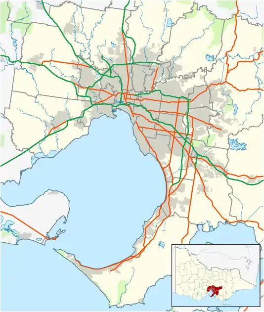
Mont Albert is an inner eastern suburb of Melbourne, Victoria, Australia, 12 kilometres east of Melbourne's Central Business District.[2] Its local government area are the Cities of Boroondara and Whitehorse. At the 2016 Census, Mont Albert had a population of 4,840.[1]
| Mont Albert Melbourne, Victoria | |||||||||||||||
|---|---|---|---|---|---|---|---|---|---|---|---|---|---|---|---|
 Hamilton Street | |||||||||||||||
 Mont Albert | |||||||||||||||
| Coordinates | 37°48′58″S 145°6′36″E | ||||||||||||||
| Population | 4,840 (2016 census)[1] | ||||||||||||||
| • Density | 3,030/km2 (7,830/sq mi) | ||||||||||||||
| Postcode(s) | 3127 | ||||||||||||||
| Area | 1.6 km2 (0.6 sq mi) | ||||||||||||||
| Location | 12 km (7 mi) from Melbourne | ||||||||||||||
| LGA(s) | |||||||||||||||
| State electorate(s) | Box Hill | ||||||||||||||
| Federal Division(s) | Kooyong | ||||||||||||||
| |||||||||||||||
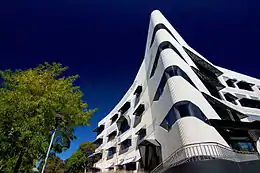
The main shopping centre of Mont Albert is Hamilton Street, a small street lined with shops. The suburb has its own railway station.
History
Mont Albert Post Office opened on 1 August 1914. A Mont Albert North Post Office opened in 1957 and closed in 1993.[3]
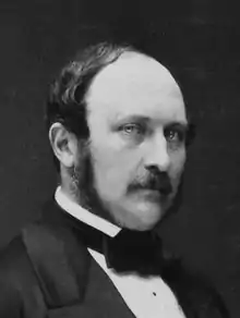
The town is most likely named after the husband of Queen Victoria, Albert, Prince Consort (1819–1861).[4] The local shopping centre (Hamilton Street (pictured to the right) began to be built in about 1913, immediately south of the railway station. A tram service along Whitehorse Road, to the suburb's north-eastern corner, was opened in 1915. Houses between the tram and railway lines are characterised as Edwardian, English Domestic Revival and Arts and Crafts traditions.[4]
Demographics
At the 2016 Australian Census, there were 4,840 people living in Mont Albert as their hometown.[5]
- 47.6% of the population were male and 52.4% were female.
- The median age of a resident in Mont Albert was 40 years old.
- There were 1,286 families residing in Mont Albert.
- There were 2,018 private dwellings in Mont Albert, with 1.7 motor vehicles being owned as a median.
- 52.9% of the population were married and 32.5% were never married.
- 23.5% of the registered citizens were of English ancestry, 21.4% of Australian ancestry, 13.3% of Chinese ancestry, 9.0% of Irish ancestry and 7.8% of Scottish ancestry.
- 66.6% of Citizens were born in Australia.
- 39.8% of the population in Mont Albert are irreligious, 19.3% Catholic, 11.0% Anglican, 7.2% not stated and 3.9% Uniting Church.
| Nationality | Population (2016 Census) |
|---|---|
| 452 | |
| 152 | |
| 111 | |
| 93 | |
| 91 |
Education
- Mont Albert Primary School, opened in 1917[7]
- Box Hill Institute (though the buildings on the East side of Elgar Road are part of Box Hill)
Public Transport
- Cable Tram
- Route 109 (Melbourne Trams) travels on Whitehorse Road through the suburb. It travels from Box Hill to Port Melbourne, and back.
- Buses
- The nearest bus terminal lies at Box Hill Railway Station, where many buses terminate and depart from. Box Hill is a neighbouring suburb of Mont Albert.
- Trains
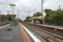
- The Mont Albert Railway Station, which is positioned on Churchill Street, runs through the suburb. Opened in August 1890,[8] this three platform station runs along the Belgrave/Lilydale Line. Services offered are in towards the city (Flinders Street Station), or out to Blackburn, Belgrave or Lilydale, run by Metro Trains.[9]
Major Attractions
Walking and Exercise Trails
Mont Albert (and Mont Albert North) contain many walking trails. These include:
- The Heritage Trail
- This is a Heritage Trail, about 5 km, developed by the City of Whitehorse. This starts and ends at the Mont Albert single storey railway station, constructed in 1911, and head east along Churchill Street.[10]
- Gawler Chain (Mont Albert North)
- A shared two-kilometre trail which runs along Bushy Creek. It starts near Koonung Secondary College (a local State School in Mont Albert North) and passes through several small parks and picnic grounds.[10]
- Koonung Trail (Mont Albert North)
- This trail runs through Elgar Park and through the Koonung Creek Linear Park. It passes by wetlands, which are a key feature of this trail.[10]
Eateries and Stores
- Mont Albert boasts many cafés, restaurants and eateries of high reputation. Hamilton Street,[11] Whitehorse Road and Mont Albert Road contain many eateries which are recommended by many locals. Hamilton Street also offers many retail stores, pharmacies, butchers and supermarkets. These stores are all accessible from the street. The opening times may vary from store to store.
Housing
- In the 12-month period to August 2020 Mont Albert reported a median house price of A$1.725 million for a four-bedroom house.[12]
Sport
There are many sporting opportunities for people of all ages, and many clubs and facilities in the neighbouring suburbs. These include:
- Mont Albert Cricket Club
- Surrey Park Lacrosse Club
- ECHO Hockey Club
Politics
State:
- In the 2018 Victorian State Election, the polling booth in Mont Albert returned the following votes:[13]
- Clark, Robert, Liberal Party of Victoria: 697 votes
- Hamer, Paul, Labor Party of Victoria: 585 votes
- Other candidates: 250 votes
- Despite citizens of Mont Albert favouring Robert Clark over Paul Hamer, Hamer was elected as the MP for Box Hill.
- After the distribution of preferences, Paul Hamer received 19,982 votes (52.10% of the vote), whilst Robert Clark received 18,369 votes (47.90% of the vote).
Federal:

- In the 2019 Australian Federal Election, the polling booth in Mont Albert returned the following votes:[14]
- Frydenberg, Josh, Liberal Party of Australia: 460 votes
- Burnside, Julian, Australian Greens: 284 votes
- Stewart, Jana, Australian Labor Party: 220 votes
- Other candidates: 126 votes
- The citizens of Mont Albert favoured Josh Frydenberg to be returned for a third term. Frydenberg suffered a −6.4% swing in Kooyong, however, he still retained the seat described as a 'blue ribbon' seat.
- After the distribution of preferences, Josh Frydenberg received 55,159 votes (55.70% of the vote), whilst Julian Burnside received 43,870 votes (44.30% of the vote).
See also
- City of Box Hill – the former local government area of which Mont Albert was a part
- List of Government Schools in Victoria – A list of Government schools, including Mont Albert Primary School
- Box Hill Institute – Box Hill Institute Website
- Belgrave Railway Line
- Lilydale Railway Line
References
- "2016 Census QuickStats Mont Albert". Australian Bureau of Statistics. Retrieved 30 May 2018.
- http://www.postcodes-australia.com/areas/vic/ferntree+gully/mont+albert
- Premier Postal History, Post Office List, retrieved 11 April 2008
- "Mont Albert | Victorian Places". www.victorianplaces.com.au. Retrieved 3 August 2020.
- "2016 Census QuickStats: Mont Albert". quickstats.censusdata.abs.gov.au. Retrieved 3 August 2020.
- "2016 Census QuickStats: Mont Albert". quickstats.censusdata.abs.gov.au. Retrieved 4 August 2020.
- School History – MONT ALBERT PRIMARY SCHOOL, retrieved 20 May 2019
- "Stationeers | Mont Albert Village". Retrieved 3 August 2020.
- "Mont Albert". www.metrotrains.com.au. Retrieved 3 August 2020.
- "Walking Trails". bpadula.tripod.com. Retrieved 3 August 2020.
- "Hamilton St". Hamilton St. Retrieved 3 August 2020.
- "Mont Albert VIC 3127, Suburb Profile & Property Market Trends | Domain". www.domain.com.au. Retrieved 3 August 2020.
- "State Election 2018: Box Hill District – First Preference Results by Voting Centre – Victorian Electoral Commission". www.vec.vic.gov.au. Retrieved 4 August 2020.
- scheme=AGLSTERMS. AglsAgent; corporateName=Australian Electoral Commission; address=50 Marcus Clarke Street, Canberra. "Polling place results". Australian Electoral Commission. Retrieved 4 August 2020.CS1 maint: multiple names: authors list (link)