City of Box Hill
The City of Box Hill was a local government area about 15 kilometres (9 mi) east of Melbourne, the state capital of Victoria, Australia. The city covered an area of 21.50 square kilometres (8.30 sq mi), and existed from 1927 until 1994.
| City of Box Hill Victoria | |||||||||||||||
|---|---|---|---|---|---|---|---|---|---|---|---|---|---|---|---|
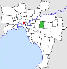 Location in Melbourne | |||||||||||||||
| Population | 48,300 (1992)[1] | ||||||||||||||
| • Density | 2,246.5/km2 (5,818/sq mi) | ||||||||||||||
| Established | 1927 | ||||||||||||||
| Area | 21.50 km2 (8.3 sq mi) | ||||||||||||||
| Council seat | Box Hill | ||||||||||||||
| Region | Melbourne | ||||||||||||||
| County | Bourke | ||||||||||||||
 | |||||||||||||||


History

Box Hill was originally included in the Nunawading Road District[2] established on 7 August 1857, which became the Shire of Nunawading on 4 May 1872. On 26 May 1925, the eastern part was severed, to create the Shire of Blackburn & Mitcham (which later became the City of Nunawading), with the remainder becoming the Borough of Box Hill on 23 December 1925. It was proclaimed a city on 28 April 1927.[3]
On 15 December 1994, the City of Box Hill was abolished, and, along with the City of Nunawading, was merged into the newly created City of Whitehorse.[4]
Council meetings were held at the Box Hill Town Hall, on Bank Street, Box Hill. It is still used for secondary council offices by the City of Whitehorse.
Box Hill has variously supported an eponymous brass band since 1889.
Wards
The City of Box Hill was subdivided into nine wards, each electing one councillor:[3]
- Bennettswood Ward
- Broughton Ward
- Burwood Ward
- Dorking Ward
- Houston Ward
- Kerrimuir Ward
- Koonung Ward
- Mont Albert Ward
- Whitehorse Ward
Suburbs
The City of Box Hill was bounded by Warrigal Road to the west, Koonung Koonung Creek to the north, Middleborough Road to the east and Highbury Road to the south.
- Box Hill
- Box Hill North
- Box Hill South
- Burwood (shared with the Cities of Camberwell and Waverley)
- Mont Albert
- Mont Albert North
- Surrey Hills (shared with the City of Camberwell)
Population
| Year | Population |
|---|---|
| 1933 | 15,332 |
| 1954 | 35,554 |
| 1958 | 45,500* |
| 1961 | 50,412 |
| 1966 | 54,504 |
| 1971 | 54,635 |
| 1976 | 50,280 |
| 1981 | 47,579 |
| 1986 | 45,785 |
| 1991 | 45,139 |
* Estimate in the 1958 Victorian Year Book.
References
- Australian Bureau of Statistics, Victoria Office (1994). Victorian Year Book. p. 49. ISSN 0067-1223.
- "Municipality of Box Hill, Victoria". Museum Victoria. Retrieved 11 September 2014.
- Victorian Municipal Directory. Brunswick: Arnall & Jackson. 1992. pp. 314–315. Accessed at State Library of Victoria, La Trobe Reading Room.
- Australian Bureau of Statistics (1 August 1995). Victorian local government amalgamations 1994-1995: Changes to the Australian Standard Geographical Classification (PDF). Commonwealth of Australia. p. 12. ISBN 0-642-23117-6. Retrieved 16 December 2007.