Montz, Louisiana
Montz is a census-designated place (CDP) in St. Charles Parish, Louisiana, United States. The population was 1,120 at the 2000 census.
Montz | |
|---|---|
 Montz Location of Montz in Louisiana | |
| Coordinates: 30°01′07″N 90°27′02″W | |
| Country | United States |
| State | Louisiana |
| Parish | St. Charles |
| Area | |
| • Total | 3.5 sq mi (9 km2) |
| • Land | 2.8 sq mi (7 km2) |
| • Water | 0.7 sq mi (2 km2) |
| Elevation | 16 ft (5 m) |
| Population (2000) | |
| • Total | 1,120 |
| • Density | 320/sq mi (120/km2) |
| Time zone | UTC-6 (CST) |
| • Summer (DST) | UTC-5 (CDT) |
| Area code(s) | 985 |
History
The Bonnet Carré Crevasse occurred in and near the present-day location of Montz. It was one of several levee breaches in the Bonnet Carré area in the mid-to-late-1800s.[1] Bonnet Carré was approximately 50 kilometers from New Orleans, Louisiana.[2] The breach occurred when excess water from the Mississippi River flowed over the east bank levee of Bonnet Carré.
Montz is located between LaPlace, Louisiana and the Bonnet Carré Spillway. It was separated from the other municipalities and communities on the east bank of the Mississippi River in St. Charles Parish by the construction of the spillway, which was completed in 1931.
Geography
Montz is located at 30°1′7″N 90°27′2″W (30.018513, -90.450683).[3]
According to the United States Census Bureau, the CDP has a total area of 3.5 square miles (9.1 km2), of which 2.8 square miles (7.3 km2) is land and 0.7 square miles (1.8 km2) (19.66%) is water.
Demographics
As of the census[4] of 2000, there were 1,120 people, 379 households, and 289 families residing in the CDP. The population density was 397.5 people per square mile (153.3/km2). There were 395 housing units at an average density of 140.2 per square mile (54.1/km2). The racial makeup of the CDP was 80.54% White, 17.77% African American, 0.18% Native American, 0.45% Asian, 0.27% from other races, and 0.80% from two or more races. Hispanic or Latino of any race were 0.98% of the population.
There were 379 households, out of which 44.1% had children under the age of 18 living with them, 58.3% were married couples living together, 12.7% had a female householder with no husband present, and 23.7% were non-families. 19.5% of all households were made up of individuals, and 6.1% had someone living alone who was 65 years of age or older. The average household size was 2.96 and the average family size was 3.43.
In the CDP, the population was spread out, with 31.5% under the age of 18, 8.1% from 18 to 24, 33.8% from 25 to 44, 19.1% from 45 to 64, and 7.4% who were 65 years of age or older. The median age was 34 years. For every 100 females, there were 102.5 males. For every 100 females age 18 and over, there were 97.7 males.
The median income for a household in the CDP was $48,388, and the median income for a family was $49,671. Males had a median income of $42,298 versus $25,978 for females. The per capita income for the CDP was $16,800. About 8.6% of families and 8.6% of the population were below the poverty line, including 5.5% of those under age 18 and 20.7% of those age 65 or over.
Education
St. Charles Parish Public School System operates public schools, including:
References
- Rogers, J.D. (May 2008). "Development of the New Orleans Flood Protection System prior to Hurricane Katrina" (PDF). Journal of Geotechnical and Geoenvironmental Engineering. 134 (5): 602–617. doi:10.1061/(ASCE)1090-0241(2008)134:5(602). Retrieved 25 October 2015.
- "The Bonnet Carre Crevasse". Old News. Ann Arbor District Library. 19 May 1871. Retrieved 25 October 2015.
- "US Gazetteer files: 2010, 2000, and 1990". United States Census Bureau. 2011-02-12. Retrieved 2011-04-23.
- "U.S. Census website". United States Census Bureau. Retrieved 2008-01-31.
- "Destrehan High School" (Archive). AdvancED. p. 4. Retrieved on December 3, 2016. "The school pulls from the five communities which make up the East Bank of St. Charles Parish: Destrehan, Montz, New Sarpy, Norco, and St. Rose."
| Wikimedia Commons has media related to Montz, Louisiana. |
Municipalities and communities of St. Charles Parish, Louisiana, United States | ||
|---|---|---|
| CDPs | 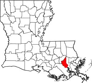 | |
| Other Unincorporated communities | ||
| Footnotes | ‡This populated place also has portions in an adjacent parish or parishes | |
| ||