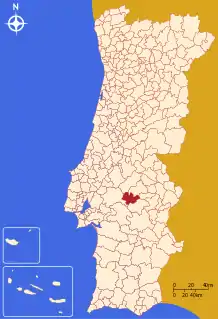
Mora, Portugal
Mora (Portuguese pronunciation: [ˈmɔɾɐ] (![]() listen)) is a municipality in Évora District in Portugal. The population in 2011 was 4,978,[1] in an area of 443.95 km².[2]
listen)) is a municipality in Évora District in Portugal. The population in 2011 was 4,978,[1] in an area of 443.95 km².[2]
Mora | |
|---|---|
 Flag  Coat of arms | |
 | |
| Coordinates: 38°56′N 8°09′W | |
| Country | |
| Region | Alentejo |
| Intermunic. comm. | Alentejo Central |
| District | Évora |
| Parishes | 4 |
| Government | |
| • President | Luís Simão de Matos (CDU) |
| Area | |
| • Total | 443.95 km2 (171.41 sq mi) |
| Population (2011) | |
| • Total | 4,978 |
| • Density | 11/km2 (29/sq mi) |
| Time zone | UTC±00:00 (WET) |
| • Summer (DST) | UTC+01:00 (WEST) |
| Local holiday | Easter Monday date varies |
| Website | http://www.cm-mora.pt |
The present Mayor is Luis Simão Duarte de Matos, elected by the Unitarian Democratic Coalition in 2013. The municipal holiday is Easter Monday.
Climate
| Climate data for Mora, 1971-2000 normals and extremes | |||||||||||||
|---|---|---|---|---|---|---|---|---|---|---|---|---|---|
| Month | Jan | Feb | Mar | Apr | May | Jun | Jul | Aug | Sep | Oct | Nov | Dec | Year |
| Record high °C (°F) | 21.0 (69.8) |
25.9 (78.6) |
29.5 (85.1) |
32.5 (90.5) |
36.0 (96.8) |
43.0 (109.4) |
43.2 (109.8) |
42.0 (107.6) |
41.9 (107.4) |
34.1 (93.4) |
27.5 (81.5) |
21.7 (71.1) |
43.2 (109.8) |
| Average high °C (°F) | 14.2 (57.6) |
15.7 (60.3) |
18.5 (65.3) |
19.6 (67.3) |
22.9 (73.2) |
27.7 (81.9) |
31.4 (88.5) |
31.3 (88.3) |
28.6 (83.5) |
23.0 (73.4) |
18.0 (64.4) |
15.0 (59.0) |
22.2 (71.9) |
| Daily mean °C (°F) | 9.1 (48.4) |
10.6 (51.1) |
12.8 (55.0) |
14.1 (57.4) |
16.9 (62.4) |
20.7 (69.3) |
23.5 (74.3) |
23.3 (73.9) |
21.3 (70.3) |
17.2 (63.0) |
12.8 (55.0) |
10.3 (50.5) |
16.1 (60.9) |
| Average low °C (°F) | 4.1 (39.4) |
5.6 (42.1) |
7.1 (44.8) |
8.6 (47.5) |
10.9 (51.6) |
13.6 (56.5) |
15.6 (60.1) |
15.3 (59.5) |
14.1 (57.4) |
11.4 (52.5) |
7.6 (45.7) |
5.6 (42.1) |
10.0 (49.9) |
| Record low °C (°F) | −9.0 (15.8) |
−5.0 (23.0) |
−3.5 (25.7) |
−1.0 (30.2) |
4.0 (39.2) |
5.5 (41.9) |
7.5 (45.5) |
7.5 (45.5) |
4.0 (39.2) |
−1.0 (30.2) |
−9.8 (14.4) |
−6.5 (20.3) |
−9.8 (14.4) |
| Average rainfall mm (inches) | 65.7 (2.59) |
61.0 (2.40) |
43.5 (1.71) |
53.0 (2.09) |
47.1 (1.85) |
18.4 (0.72) |
9.1 (0.36) |
5.5 (0.22) |
25.0 (0.98) |
68.6 (2.70) |
70.6 (2.78) |
87.6 (3.45) |
555.1 (21.85) |
| Average precipitation days (≥ 0.1 mm) | 11.0 | 11.3 | 8.5 | 10.4 | 8.4 | 4.5 | 1.6 | 1.3 | 4.5 | 9.8 | 9.6 | 12.2 | 93.1 |
| Source: Instituto de Meteorologia[3] | |||||||||||||
Parishes
Administratively, the municipality is divided into 4 civil parishes (freguesias):[4]
- Brotas
- Cabeção
- Mora
- Pavia
Gallery
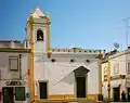 Main church of Mora
References
- Instituto Nacional de Estatística
- "Áreas das freguesias, concelhos, distritos e país". Archived from the original on 2018-11-05. Retrieved 2018-11-05.
- "Monthly Averages for Mora (1971–2000)" (PDF). Instituto de Meteorologia.
- Diário da República. "Law nr. 11-A/2013, page 552 79" (pdf) (in Portuguese). Retrieved 28 July 2014.
This article is issued from Wikipedia. The text is licensed under Creative Commons - Attribution - Sharealike. Additional terms may apply for the media files.