Motiti Island
Motiti Island (Māori: Mōtītī) is located off the Bay of Plenty coast of New Zealand's North Island. It is 21 kilometres (13 mi) north-east of Tauranga and 9.4 kilometres (5.8 mi) north-east of Papamoa. There were 18 homes occupied by 27 people on the island in the 2006 census.[1]
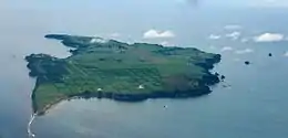 An aerial view of Motiti Island. | |
 Motiti Island | |
| Geography | |
|---|---|
| Location | Bay of Plenty |
| Coordinates | 37.6257°S 176.4221°E |
| Total islands | 1 |
| Major islands | 1 |
| Area | 10 km2 (3.9 sq mi) |
| Highest elevation | 57 m (187 ft) |
| Administration | |
| Demographics | |
| Population | 27[1] (2006) |
| Pop. density | 2.7/km2 (7/sq mi) |
| Ethnic groups | Maori |
Geography
A relatively flat island covering some 10 km2 (3.9 sq mi), Motiti Island is composed mainly of Miocene volcanic rocks, overlaid with more recent sediments in the south.[2] The principal activity on the island is agriculture, with a developing avocado plantation.[3] Most residents and visitors travel to the island by air.
There is no public infrastructure (e.g. no public wharf) and the whole island is in private ownership. Access is difficult and expensive.[4] Bay of Plenty Regional Council has regional council responsibility for Motiti Island.[5] No territorial authority council is responsible for it – therefore residents pay no rates and there are no council services. Day-to-day administration is by the Department of Internal Affairs.[4]
History and culture
Colonial history
On 2 November 1769, during his first voyage, Captain Cook sailed close inshore to Motiti Island, where he reported the most extensive complex of fortified villages he had yet seen. In his journal he refers to it as the "Flat Island".[6]
Recent history
On 9 October 2011, the 45' launch M/V Excalibur ran aground offshore in bad weather. The crew of six was rescued, but the ship was considered a total loss.[7]
In 2011 the MV Rena ran aground on Astrolabe Reef. Oil from the resulting spill, as well as shipping containers and their contents, reached the shoreline of the island.[8]
In October 2013, Motiti Island residents rejected an offer by the MV Rena's owners to start a development project for the island, in return for being able to leave the Rena wreckage where it lay.[9] The plan included:
- Building a landing point for barges.
- Creating a one-lane, all-weather road to the airstrip.
- Installing a new cellphone tower to improve communications.
- Running an underground cable from the mainland to improve power supply.
- Putting a permanent beacon on Astrolabe Reef.
- Building a Rena memorial from the ship's anchor.
Marae
The island has two marae, belonging to the Ngāti Awa hapū of Ngāti Maumoana, Ngāti Makerewai and Ngāti Takahanga: Te Hinga o te Ra or Te Karioi Marae and Te Hinga o te Ra meeting house; and Te Rua Kopiha Marae and Tamatea ki te Huatahi meeting house.[10][11]
In October 2020, the Government committed $4,871,246 from the Provincial Growth Fund to upgrade a group of 12 marae, including Te Rua Kopiha Marae. The funding was expected to create 23 jobs.[12]
Aerodrome
Sunair operates from Motiti Island to Tauranga with Cessna 172 aircraft.
See also
References
- QuickStats About Motiti Island, 2006 Census, Statistics New Zealand. Retrieved 29 October 2010.
- Motiti Island, An Encyclopaedia of New Zealand (1966). Retrieved 29 October 2010.
- "Motiti Island: Population 40, just how they like it". The New Zealand Herald. 6 January 2012. Retrieved 28 November 2018.
- Vance, Andrea (25 November 2018). "Motiti". stuff.co.nz. Retrieved 25 November 2018.
- "Administration of Motiti Island". Department of Internal Affairs. Retrieved 28 November 2018.
- Hare, McLintock, Alexander; Wellington., Thomas Ludovic Grant-Taylor, M.SC., New Zealand Geological Survey, Lower Hutt and Bernard John Foster, M.A., Research Officer, Department of Internal Affairs; Taonga, New Zealand Ministry for Culture and Heritage Te Manatu. "MOTITI ISLAND". Teara.gov.tnz. Retrieved 4 October 2018.
- "The Law Offices of Countryman & McDaniel". Cargolaw.com. Retrieved 4 October 2018.
- "Containers, oil to spill from 'dying' Rena". New Zealand: Stuff.co.nz. 17 October 2011. Retrieved 20 October 2011.
- "Archived copy". Archived from the original on 19 October 2013. Retrieved 19 October 2013.CS1 maint: archived copy as title (link)
- "Te Kāhui Māngai directory". tkm.govt.nz. Te Puni Kōkiri.
- "Māori Maps". maorimaps.com. Te Potiki National Trust.
- "Marae Announcements" (Excel). growregions.govt.nz. Provincial Growth Fund. 9 October 2020.
| Wikimedia Commons has media related to Motiti Island. |