Mount Mohl
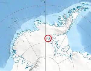
Mount Mohl (78°33′S 85°5′W) is a mountain, 3,710 metres (12,170 ft) high, at the east side of Vinson Massif, surmounting the ridge between the heads of Dater Glacier and Thomas Glacier, in the Sentinel Range of the Ellsworth Mountains, Antarctica. It is connected to Doyran Heights to the northeast by Goreme Col.
The peak was first mapped by the United States Geological Survey from surveys and U.S. Navy air photos from 1957–59, and was named by the Advisory Committee on Antarctic Names for Commander Edgar A. Mohl, U.S. Navy, who was a hydrographic officer on the staff of the Commander, U.S. Navy Task Force 43, during Deep Freeze Operations I and II in 1955–56 and 1956–57.[1]
See also
- Mountains in Antarctica
Maps
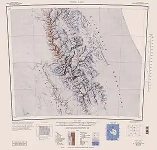
- Vinson Massif. Scale 1:250 000 topographic map. Reston, Virginia: US Geological Survey, 1988.
- Antarctic Digital Database (ADD). Scale 1:250000 topographic map of Antarctica. Scientific Committee on Antarctic Research (SCAR). Since 1993, regularly updated.
References
- "Mount Mohl". Geographic Names Information System. United States Geological Survey. Retrieved 2013-10-28.
![]() This article incorporates public domain material from the United States Geological Survey document: "Mount Mohl". (content from the Geographic Names Information System)
This article incorporates public domain material from the United States Geological Survey document: "Mount Mohl". (content from the Geographic Names Information System)
| General |
| .svg.png.webp) |
|---|---|---|
| Regions | ||
| Waterways | ||
| Famous explorers | ||