Research stations in Antarctica

A number of governments have set up permanent research stations in Antarctica and these bases are widely distributed. Unlike the drifting ice stations set up in the Arctic, the Research stations of the Antarctic are constructed either on rock or on ice that is (for practical purposes) fixed in place.
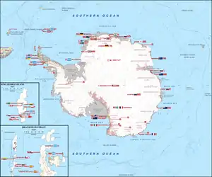
Map shows the location of permanent Antarctic Research stations
Countries that have one or more stations in Antarctica

Many of the stations are staffed around the year. A total of 42 countries (as of October 2006), all signatories to the Antarctic Treaty, operate seasonal (summer) and year-round research stations on the continent. The population of people performing and supporting scientific research on the continent and nearby islands varies from approximately 4,000 during the summer season to 1,000 during winter (June).[1] In addition to these permanent stations, approximately 30 field camps are established each summer to support specific projects.[2]

History

First bases
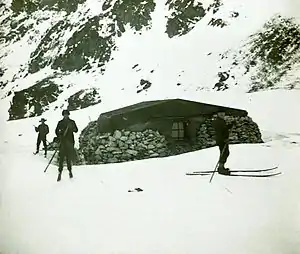
"Omond House", the first permanent base, built in 1903 by the Scottish National Antarctic Expedition

During the Heroic Age of Antarctic Exploration in the late 19th century, the first bases on the continent were established. In 1898, Carsten Borchgrevink, a Norwegian/British explorer, led the British Antarctic Expedition to Cape Adare, where he established the first Antarctic base on Ridley Beach. The expedition is often referred to now as the Southern Cross Expedition, after expedition ship name. Most of the staff were Norwegian, but the funds for the expedition were British, provided by Sir George Newnes. The 10 members of the expedition explored Robertson Bay to the west of Cape Adare by dog teams, and later, after being picked up by the ship at the base, went ashore on the Ross Ice Shelf for brief journeys. The expedition hut is still in good condition and visited frequently by tourists.

The hut was later occupied by Scott's Northern Party under the command of Victor Campbell for a year in 1911, after its attempt to explore the eastern end of the ice shelf discovered Roald Amundsen already ashore preparing for his assault on the South Pole.

In 1903, Dr William S. Bruce's Scottish National Antarctic Expedition set off to Antarctica, with one of its aims to establish a meteorological station in the area. After the expedition failed to find land, Bruce decided to head back to the Laurie Island in the South Orkneys and find an anchorage there.[3] The islands were well-situated as a site for a meteorological station, and their relative proximity to the South American mainland allowed a permanent station to be established.[4] Bruce instituted a comprehensive programme of work, involving meteorological readings, trawling for marine samples, botanical excursions, and the collection of biological and geological specimens.[3]

The major task completed during this time was the construction of a stone building, christened "Omond House".[5] This was to act as living accommodation for the parties that would remain on Laurie Island to operate the proposed meteorological laboratory. The building was constructed from local materials using the dry stone method, with a roof improvised from wood and canvas sheeting. The completed house was 20 feet by 20 feet square (6m × 6m), with two windows, fitted as quarters for six people. Rudmose Brown wrote: "Considering that we had no mortar and no masons' tools it is a wonderfully fine house and very lasting. I should think it will be standing a century hence ..."[6]

Bruce later offered to Argentina the transfer of the station and instruments on the condition that the government committed itself to the continuation of the scientific mission.[7] Bruce informed the British officer William Haggard of his intentions in December 1903, and Haggard ratified the terms of Bruce's proposition.[8]

The Scotia sailed back for Laurie Island on 14 January 1904 carrying on board Argentinean officials from the Ministry of Agriculture, National Meteorological Office, Ministry of Livestock and National Postal and Telegraphs Office. In 1906, Argentina communicated to the international community the establishment of a permanent base on the South Orkney Islands.

WWII and postwar expansion

Little happened for the following forty years until the Second World War, when the British launched Operation Tabarin in 1943, to establish a presence on the continent. The chief reason was to establish solid British claims to various uninhabited islands and parts of Antarctica, reinforced by Argentine sympathies toward Germany.
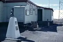
View of Chile's Captain Arturo Prat Base, established in 1947

Prior to the start of the war, German aircraft had dropped markers with swastikas across Queen Maud Land in an attempt to create a territorial claim (New Swabia).[9] Led by Lieutenant James Marr, the 14-strong team left the Falkland Islands in two ships, HMS William Scoresby (a minesweeping trawler) and Fitzroy, on Saturday January 29, 1944. Marr had accompanied the British explorer Sir Ernest Shackleton on his final Antarctic expedition in 1921 - 1922.

Bases were established during February near the abandoned Norwegian whaling station on Deception Island, where the Union Flag was hoisted in place of Argentine flags, and at Port Lockroy (on February 11) on the coast of Graham Land. A further base was founded at Hope Bay on February 13, 1945, after a failed attempt to unload stores on February 7, 1944. These bases were the first ever to be constructed on the mainland Antarctica.[10]

The United States starting under the leadership of Admiral Richard E. Byrd constructed a series of five bases near the Bay of Whales named Little America between 1929 and 1958. All of them have now drifted off to sea on icebergs.

Operation provoked a massive expansion in international activity after the war. Chile organized its First Chilean Antarctic Expedition in 1947–48. Among other accomplishments, it brought the Chilean president Gabriel González Videla to personally inaugurate one of its bases, thereby becoming the first head of state to set foot on the continent.[11] Signy Research Station (UK) was established in 1947, Australia's Mawson Station in 1954, Dumont d'Urville Station was the first French station in 1956. In that same year, the United States built McMurdo Station and Amundsen–Scott South Pole Station, and the Soviet Union built Mirny Station.

List of research stations

The United States maintains the southernmost Base and the largest base and research station in Antarctica, Amundsen–Scott South Pole Station. The second-southernmost base is the Chinese Kunlun Station at 80°25′02″S during the summer season, and the Russian Vostok Station at 78°27′50″S during the winter season.


Station
name
LOCODETypeCountryYear
Est.
Administered byLocation Status &
Activities
CoordinatesTime zoneAverage Annual Temp °C
AboaAQ ABASummer Finland1988Finnish Antarctic Research ProgramQueen Maud LandActive73°02′32″S 13°24′26″W
Aguirre CerdaAQSummer Chile1955Instituto Antártico ChilenoDeception IslandClosed
1967
62°56′01″S 60°35′45″W
Amundsen–Scott South PoleAQ AMSPermanent United States1957United States Antarctic ProgramGeographical South Pole Active90°S 0°EUTC+12*-49.5
ArctowskiAQ ARCPermanent Poland1977Polish Academy of SciencesKing George IslandActive62°09′37″S 58°28′24″W
Arrival Heights Laboratory[12]AQPermanent New Zealand1959Antarctica New ZealandRoss Island Active77°49′50″S 166°39′40″E
Arrival Heights Satellite Station[12]AQPermanent New Zealand1959Antarctica New ZealandRoss IslandActive77°49′48″S 166°39′42″E
ArtigasAQ ARTPermanent Uruguay1984Uruguayan Antarctic InstituteKing George IslandActive62°11′04″S 58°54′14″WUTC−3
Arturo ParodiAQSummer Chile1999Instituto Antártico ChilenoEllsworth LandClosed
Relocated to
Union Glacier
2014
80°18′15″S 81°23′13″W
Arturo PratAQ APTPermanent Chile1947Chilean NavyGreenwich IslandActive62°28′44″S 59°39′52″WUTC−3-2
AsukaAQSummer Japan1985National Institute of Polar ResearchQueen Maud LandClosed
Unmanned activity
71°31′33″S 24°06′41″E
Beaver Lake[13]AQSummer Australia1995Australian Antarctic DivisionBeaver LakeActive70°47′42″S 68°10′08″E
Belgrano IAQPermanent Argentina1955Instituto Antártico ArgentinoFilchner-Ronne Ice ShelfAbandoned
1980
77°46′S 38°11′WUTC−3
Belgrano IIAQ BELPermanent Argentina1979Instituto Antartico ArgentinoCoats LandActive77°52′25″S 34°37′39″WUTC−3-13.3
Belgrano IIIAQPermanent Argentina1980Instituto Antártico ArgentinoBerkner IslandAbandoned
1984
77°54′02″S 45°47′01″WUTC−3
BellingshausenAQ BHNPermanent Russia1968Russian Antarctic ExpeditionKing George Island Active62°11′55″S 58°57′38″W-2.3
BharatiAQPermanent India2012National Centre for Polar and Ocean ResearchLarsemann HillsActive69°24′29″S 76°11′14″E
BorgaAQSummer South Africa1969South African National Antarctic ProgrammeBorg MassifClosed
1976
72°58′00″S 3°48′00″W
BrocktonAQSummer United States1965United States NavyRoss Ice ShelfAbandoned
1972
80°02′00″S 178°42′00″W
BrownAQSummer Argentina1951Instituto Antártico ArgentinoParadise HarborActive64°53′44″S 62°52′15″WUTC−3+2
ByrdAQPermanent
Summer
since 1972
 United States1957United States Antarctic ProgramMarie Byrd Land Closed
2005
80°00′53″S 119°33′56″W-28.1
CámaraAQSummer Argentina1953Instituto Antartico ArgentinoHalf Moon IslandActive62°35′41″S 59°55′07″WUTC−3
Carvajal
(ex Station T)
AQSummer Chile1984Instituto Antártico ChilenoAdelaide IslandActive67°45′40″S 68°54′52″W
CaseyAQ CASPermanent Australia1957Australian Antarctic DivisionVincennes BayActive66°16′57″S 110°31′36″EUTC+8-8
Charcot[14]AQPermanent France1957French Polar InstituteAdélie LandClosed 1959
Abandoned
69°22′30″S 139°01′00″E
CollinsAQSummer Chile2006Instituto Antártico ChilenoFildes PeninsulaActive62°10′09″S 58°51′07″W
Comandante FerrazAQ CFZPermanent Brazil1984Brazilian Antarctic ProgramKing George IslandActive62°05′07″S 58°23′29″WUTC−3-1.8
ConcordiaAQ CONPermanent Italy
 France
2005National Antarctic Research Program
and
IPEV
Dome C
Antarctic Plateau
Active75°05′59″S 123°19′56″EUTC+10-51.7
Dakshin GangotriAQPermanent India1984National Centre for Polar and Ocean ResearchDakshin Gangotri GlacierClosed
1990
Support base
69°24′24″S 76°11′36″E
DallmannAQSummer Germany1994Alfred Wegener InstituteCarlini StationActive62°14′18″S 58°40′04″W
DavisAQ DAVPermanent Australia1957Australian Antarctic DivisionPrincess Elizabeth LandActive68°34′36″S 77°58′03″EUTC+7-13.0
DeceptionAQSummer Argentina1948Instituto Antartico ArgentinoDeception IslandActive62°58′31″S 60°41′52″WUTC−3
Dirck Gerritsz LaboratoryAQSummer Netherlands2013British Antarctic SurveyRothera StationActive67°34′08″S 68°07′29″W-5.3
Dobrowolski
(ex Oasis)
AQSummer Poland1959Polish Academy of SciencesWilkes LandClosed
1998
66°16′28″S 100°45′00″E
Dome FujiAQ DMFSummer Japan1995National Institute of Polar ResearchQueen Maud LandClosed77°18′59″S 39°42′04″E-54.3
DrescherAQSummer Germany1986Alfred Wegener InstituteQueen Maud LandClosed
2004
72°50′00″S 19°02′00″W
DruzhbaAQSummer Soviet Union1960Soviet Antarctic ExpeditionZavadovskiy IslandClosed
1960
66°43′00″S 86°24′00″E
Drúzhnaya 1AQSummer Soviet Union1975Soviet Antarctic ExpeditionFilchner-Ronne Ice ShelfClosed
1986
Lost
77°34′00″S 40°13′00″W
Drúzhnaya 2AQSummer Soviet Union1982Soviet Antarctic ExpeditionLassiter CoastClosed
1986
75°36′00″S 57°52′00″W
Drúzhnaya 3AQSummer Soviet Union1982Soviet Antarctic ExpeditionQueen Maud LandClosed
1986
71°06′00″S 10°49′00″W
Drúzhnaya 4AQ DRZSummer Soviet Union
 Russia
1987Soviet Antarctic Expedition
Russian Antarctic Expedition
Princess Elizabeth LandClosed
1995
69°44′00″S 73°42′00″E
Dumont d'UrvilleAQ DDUPermanent France1956IPEVAdélie LandActive66°39′46″S 140°00′07″EUTC+10-11.1
E BaseAQSummer South Africa1985Fimbul Ice ShelfActive70°18′00″S 2°26′00″W
East BaseAQPermanent United States1941United States Antarctic Service ExpeditionStonington IslandClosed
1948
68°11′02″S 66°59′53″W
Eco-NelsonAQPermanent Czechoslovakia
 Czech Republic
1989Private stationNelson Island Active62°14′47″S 58°58′56″W
Eduardo Frei
and
Villa Las Estrellas
AQPermanent Chile1969Chilean Air ForceKing George IslandActive62°11′35″S 58°58′55″WUTC−3-2.3
EightsAQPermanent United States1963National Science FoundationQueen Maud LandClosed
1965
75°14′00″S 77°10′00″W
EllsworthAQPermanent United States
 Argentina
1957United States Navy
Instituto Antártico Argentino
Filchner-Ronne Ice Shelf Transferred to Argentina in 1959
Closed 1962
77°39′00″S 41°02′00″W-22
Elichiribehety
(ex Station D)
AQSummer Uruguay1997Uruguayan Antarctic InstituteHope BayActive63°24′09″S 56°59′27″W
EscuderoAQ ESCPermanent Chile1994Instituto Antártico ChilenoKing George IslandActive62°12′05″S 58°57′44″WUTC−3
EsperanzaAQ ESPPermanent Argentina1953Instituto Antartico ArgentinoHope BayActive63°23′51″S 56°59′52″WUTC−3-4.6
FilchnerAQSummer Germany1982Alfred Wegener InstituteFilchner-Ronne Ice ShelfAbandoned
and lost 1999
77°06′00″S 50°24′00″W
Fossil Bluff
(ex Station KG)
[15]
AQPermanent intermittently
Summer
 United Kingdom1961British Antarctic SurveyAlexander Island Active71°19′24″S 68°17′16″W
Gabriel de CastillaAQ GDCSummer Spain1989Spanish National Research CouncilDeception Island Active
Marine biology[16]
62°58′37″S 60°40′31″W
General Bernardo O'HigginsAQ OHGPermanent Chile1948Chilean ArmyCape LegoupilActive
Logistics
63°19′15″S 57°53′59″WUTC−3-3.9
Georg ForsterAQPermanent East Germany
 Germany
1976

1990
Alfred Wegener InstituteFilchner-Ronne Ice Shelf Closed
1993
70°46′39″S 11°50′56″E
German Antarctic Receiving StationAQPermanent Germany1991German Aerospace CenterCape LegoupilActive63°19′15″S 57°54′02″W
Giacomo Bove[17]AQ BGBSummer Italy1976Private stationItalia Valley Taken apart by the Argentine Navy 197662°10′05″S 58°30′18″W
GondwanaAQSummer Germany1983Alfred Wegener InstituteTransantarctic MountainsActive74°38′07″S 164°13′19″E
González VidelaAQSummer Chile1951Chilean Air ForceWaterboat Point
Graham Land
Active64°49′26″S 62°51′25″W
Great WallAQ GWLPermanent China1985Polar Research Institute of ChinaKing George Island Active62°13′01″S 58°57′43″W
Guillermo MannAQSummer Chile1991Instituto Antártico ChilenoCape ShirreffActive62°28′12″S 60°46′17″W
HallettAQPermanent
Summer since 1964
 United States
 New Zealand
1956International Geophysical YearHallett PeninsulaClosed 197372°19′00″S 170°16′00″E
HalleyAQ HLYPermanent
Temporary Summer[18]
 United Kingdom1956British Antarctic Survey [19]Brunt Ice Shelf Active75°36′45″S 26°11′52″W
relocated 23 kilometres (14 mi) inland[20]
-18.5
Jang BogoAQ JBSPermanent South Korea2014Korea Polar Research InstituteTerra Nova BayActive74°37′26″S 164°13′44″EUTC+11
JinnahAQSummer Pakistan1991Pakistan Antarctic ProgrammeSør Rondane Mountains, Queen Maud LandActive70°24′00″S 25°45′00″E
Juan Carlos PrimeroAQ JCPSummer Spain1988Spanish National Research CouncilSouth Bay, Livingston IslandActive62°39′47″S 60°23′17″WUTC−3
Jubany
(renamed Carlini)
AQ JUBPermanent Argentina1953Instituto Antartico ArgentinoKing George IslandActive62°14′18″S 58°40′04″WUTC−3
Julio RipamontiAQSummer Chile1982Instituto Antártico ChilenoArdley IslandActive62°12′36″S 58°56′08″WUTC-3
King Baudouin
(first station)
AQPermanent Belgium1957National Center for Polar ResearchPrincess Ragnhild CoastClosed 1961
Abandoned
70°25′33″S 24°19′00″E
King Baudouin
(second station)
AQPermanent Belgium
 Netherlands
1964National Center for Polar ResearchPrincess Ragnhild CoastClosed 1967
Abandoned
70°25′33″S 24°19′00″E
King SejongAQ KSGPermanent South Korea1988Korea Polar Research InstituteKing George Island Active62°13′22″S 58°47′18″WUTC−3
KohnenAQ KHNSummer Germany2001Alfred Wegener InstituteQueen Maud LandActive75°00′07″S 0°04′00″E
KomsomolskayaAQPermanent Soviet Union1957Arctic and Antarctic Research InstituteQueen Mary Land Closed
1962
74°06′S 94°30′E-52
KunlunAQSummer China2009Polar Research Institute of ChinaDome AActive80°25′02″S 77°06′59″E
LawAQ LAWSummer Romania1986Romanian Polar Research InstituteLarsemann Hills
Princess Elizabeth Land
Active69°22′25″S 76°22′18″E
LázarevAQPermanent Soviet Union1959Russian Antarctic ExpeditionLazarev Ice ShelfClosed 1961
Abandoned
69°58′00″S 12°55′00″E
LenieAQSummer United States1985United States Antarctic ProgramAdmiralty Bay Active62°10′42″S 58°26′46″W
LeningradskayaAQSummer Russia1971Russian Antarctic ExpeditionOates Coast
Victoria Land
Closed 1991
69°30′05″S 159°23′31″E-13
Little AmericaAQPermanent United States1929Ross Ice ShelfLost
1987
78°12′S 162°12′W-22
Little RockfordAQSummer United States1958Marie Byrd LandClosed 1965
Abandoned
79°30′00″S 147°19′00″W
Machu PicchuAQSummer Peru1989Instituto Antártico Peruano [21]Admiralty Bay
King George Island
Active62°05′29″S 58°28′12″W
MaitriAQ MTRPermanent India1989National Centre for Polar and Ocean ResearchSchirmacher OasisActive70°46′00″S 11°43′53″E
MaldonadoAQSummer Ecuador1990Instituto Antártico EcuatorianoGreenwich IslandActive62°26′57″S 59°44′29″W
MarambioAQ MRBPermanent Argentina1969Instituto Antartico ArgentinoMarambio IslandActive64°14′28″S 56°37′36″WUTC−3-8.1
MatienzoAQSummer Argentina1961Instituto Antartico ArgentinoGraham LandActive64°58′32″S 60°04′17″WUTC−3-11.6
MaudheimAQPermanent Norway
 Sweden
 United Kingdom
1949Norwegian–British–Swedish Antarctic ExpeditionQueen Maud Land Closed
1952
71°03′00″S 10°56′00″W
MawsonAQ MAWPermanent Australia1954Australian Antarctic DivisionMac Robertson LandActive67°36′12″S 62°52′27″EUTC+6-8.3
McMurdoAQ MCMPermanent United States1956United States Antarctic ProgramRoss IslandActive77°50′47″S 166°40′06″EUTC+12*-19.7
MelchiorAQSummer Argentina1947Instituto Antartico ArgentinoMelchior IslandsActive64°19′32″S 62°58′34″WUTC−3-3.6
MendelAQSummer Czech Republic2006Masaryk UniversityJames Ross IslandActive63°48′02″S 57°52′56″W
MirAQSummer Soviet Union1958
Meteo
Russian Antarctic ExpeditionDrygalski IslandClosed
1960
65°45′S 92°30′E
MirnyAQ MIRPermanent Russia1956Russian Antarctic ExpeditionDavis SeaActive66°33′11″S 93°00′35″E-11.3
MizuhoAQSummer Japan1970National Institute of Polar ResearchMizuho PlateauActive
occasionally
transhipment station
70°41′57″S 44°16′45″E-31
MolodyozhnayaAQSummer Russia1962
reopened
in 2007
Russian Antarctic ExpeditionThala Hills
East Antarctica
Closed 1990
Active
Meteorology
[22]
67°39′55″S 45°50′18″E-11.0
Neumayer IAQ NEUPermanent Germany1981Alfred Wegener InstitutePrincess Martha CoastClosed
1993
70°39′05″S 8°15′47″W
Neumayer IIAQ NEUPermanent Germany1992Alfred Wegener InstituteQueen Maud LandClosed
2009
70°38′16″S 8°15′42″W
Neumayer IIIAQ NEUPermanent Germany2009Alfred Wegener InstituteAtka BayActive70°40′38″S 8°16′18″WUTC
NorwayAQPermanent Norway1957Sixth Norwegian Antarctic ExpeditionFimbul Ice ShelfClosed 1960
Transferred to
South Africa
70°30′S 2°30′W
NovolazarevskayaAQ NOVPermanent Russia1961Russian Antarctic ExpeditionQueen Maud LandActive70°46′36″S 11°49′20″E-10.3
Oasis
(renamed
Dobrowolski)
AQSummer Soviet Union
 Poland
1956

1959
Russian Antarctic ExpeditionBunger HillsActive66°16′00″S 100°44′00″E
Oazis 2AQSummer Soviet Union1987Russian Antarctic ExpeditionBunger HillsClosed
1995
66°16′28″S 100°45′00″E
OrcadasAQ ORCPermanent Argentina1904Instituto Antartico Argentino
Argentine Navy
Laurie Island
South Orkney Islands
Active60°44′17″S 44°44′17″WUTC−3-3.0
PalmerAQ PLMPermanent United States1968United States Antarctic ProgramAnvers IslandActive64°46′27″S 64°03′10″WUTC−3-2
PetrelAQSummer Argentina1952Instituto Antartico ArgentinoDundee IslandActive63°28′41″S 56°13′44″WUTC−3-6
PionérskayaAQPermanent Soviet Union1956Russian Antarctic ExpeditionQueen Mary LandClosed
1959
69°44′00″S 95°31′00″E-38
PlateauAQPermanent United States1965United States Navy
National Science Foundation
Queen Maud LandClosed
1969
79°15′03″S 40°33′38″E-56.7
PobedaAQSummer Soviet Union1960Russian Antarctic ExpeditionQueen Mary LandClosed
1960
64°39′S 98°54′E
Pole of inaccessibility Soviet Union1958Kemp LandClosed
1958
82°06′00″S 54°58′00″E-58.2
Port MartinAQPermanent France1950French Antarctic ExpeditionCape MargerieClosed
1952
66°49′06″S 141°24′02″E
PrimaveraAQSummer Argentina1977Instituto Antartico ArgentinoGraham LandActive64°09′21″S 60°57′19″WUTC−3
Princess ElisabethAQSummer Belgium2007International Polar Foundation
Energy passive station.
Queen Maud Land Reopened
23 November 2017[23]
71°57′00″S 23°20′49″E
ProgressAQ PROPermanent Soviet Union
 Russia
1988Russian Antarctic ExpeditionPrydz BayActive69°22′25″S 76°22′18″E-9.4
RisopatrónAQSummer Chile1954Instituto Antártico ChilenoRobert IslandActive62°22′42″S 59°42′03″W
Rothera
(ex Station R)
[24]
AQ ROTPermanent United Kingdom1975British Antarctic SurveyAdelaide IslandActive67°34′06″S 68°07′33″W
RusskayaAQSummer Soviet Union
 Russia
1980
reopened in 2007
Russian Antarctic ExpeditionMarie Byrd LandClosed 1990
Active
74°46′00″S 136°48′10″WUTC−6
[25]
SalyutAQSummer Soviet Union1978Russian Antarctic ExpeditionQueen Mary LandClosed
1978
65°32′00″S 96°30′00″E
San MartínAQ SMTPermanent Argentina1951Instituto Antartico ArgentinoBarry IslandActive68°07′48″S 67°06′05″WUTC−3-4.6
SANAE IAQ SNAPermanent South Africa1960South African National Antarctic ProgrammeFimbul Ice ShelfClosed 1963
Abandoned
70°18′00″S 2°22′00″W
SANAE IIAQ SNAPermanent South Africa1971South African National Antarctic ProgrammeFimbul Ice ShelfClosed 1979
Abandoned
70°18′00″S 2°22′00″W
SANAE IIIAQ SNAPermanent South Africa1979South African National Antarctic ProgrammeFimbul Ice ShelfClosed 1997
Abandoned
70°18′00″S 2°22′00″W
SANAE IVAQ SNAPermanent South Africa1960
SANAE I
South African National Antarctic ProgrammeVesleskarvet
Queen Maud Land
Active71°40′22″S 2°50′26″WUTC+2
Sarie MaraisAQSummer South Africa1982South African National Antarctic ProgrammeAhlmann RidgeClosed 1999
Dismantled 2001
Geology
Biology
72°01′35″S 2°48′18″W
Scott BaseAQ SBAPermanent New Zealand1957Antarctica New ZealandRoss IslandActive77°50′57″S 166°46′06″EUTC+12-19.6
ShirreffAQSummer United States1991National Oceanic and Atmospheric AdministrationCape ShirreffActive62°28′13″S 60°46′16″W
Signy
(ex Station H)
[26]
AQ SGNPermanent
1947-1995
Summer
since 1996
 United Kingdom1947British Antarctic SurveySigny Island
South Orkney Islands
Active60°42′29″S 45°35′42″W-3
Site 2AQSummer United States1957Law DomeClosed 1966
Abandoned
Glaciology
66°30′07″S 113°12′09″E
SyowaAQ SYWPermanent Japan1957National Institute of Polar ResearchEast Ongul IslandActive69°00′16″S 39°34′54″EUTC+3-10.5
SipleAQSummer United States1973Stanford's STAR LabEllsworth LandClosed
1988
75°55′00″S 83°55′00″W
SobralAQPermanent Argentina1965Instituto Antártico ArgentinoFilchner-Ronne Ice ShelfClosed
1968
81°04′45″S 40°31′12″W
SodrúzhestvoAQSummer Soviet Union1971Russian Antarctic ExpeditionAmery Ice ShelfClosed
1974
69°43′00″S 73°44′00″E
South IceAQPermanent United Kingdom1957Commonwealth Trans-Antarctic ExpeditionEdith Ronne LandClosed 1958
Abandoned
82°05′00″S 30°00′00″W
SovetskayaAQPermanent Soviet Union1958Arctic and Antarctic Research InstituteKaiser Wilhelm II Land Closed
1959
Abandoned
77°58′00″S 89°16′00″E
SoyuzAQPermanent Soviet Union1982Russian Antarctic ExpeditionPrince Charles MountainsClosed
1989
70°34′36″S 68°47′30″EUTC+5
St. Kliment OhridskiAQSummer Bulgaria1988Bulgarian Antarctic InstituteEmona Anchorage
Livingston Island
Active62°38′29″S 60°21′53″WUTC−3
Station A[27]AQSummer United Kingdom1944United Kingdom Antarctic Heritage TrustGoudier IslandActive64°49′31″S 63°29′37″W
Station B[28]AQPermanent United Kingdom1944Falkland Islands and Dependencies Aerial Survey ExpeditionDeception IslandClosed
1969
62°58′38″S 60°33′50″W
Station C[29]AQSummer United Kingdom1946British Antarctic SurveyCape GeddesClosed 1947
Abandoned
60°41′16″S 44°34′24″W
Station D[30]AQPermanent United Kingdom1945British Antarctic SurveyHope BayClosed
1964
63°24′09″S 56°59′27″W
Station E[31]AQPermanent United Kingdom1946British Antarctic SurveyStonington IslandClosed
1975
68°11′08″S 66°59′41″W
Station F
(renamed Faraday)[32]
AQPermanent United Kingdom1947British Antarctic SurveyGalindez IslandClosed
1996
65°14′45″S 64°15′28″W-3.3
Station G[33]AQPermanent United Kingdom1947British Antarctic SurveyAdmiralty BayClosed
1961
62°05′14″S 58°23′39″W
Station J[34]AQPermanent United Kingdom1957British Antarctic SurveyProspect PointClosed 1959
Removed 2004
65°59′55″S 65°19′06″W
Station N[35]AQPermanent United Kingdom1955British Antarctic SurveyAnvers IslandClosed 1958
Demolished
1991
64°45′36″S 64°04′48″W
Station O[36]AQPermanent United Kingdom1956British Antarctic SurveyDanco IslandClosed 1959
Demolished
2004
64°44′00″S 62°36′00″W
Station P[37]AQSummer United Kingdom1957British Antarctic SurveyMateev CoveClosed
1958
62°38′58″S 60°35′25″W
Station T[38] AQPermanent United Kingdom1961British Antarctic SurveyAdelaide IslandClosed
1977
67°45′40″S 68°54′52″W
Station V[39]AQPermanent United Kingdom1953British Antarctic SurveyView PointClosed
1963
63°33′16″S 57°22′42″W
Station W[40]AQPermanent United Kingdom1956British Antarctic SurveyDetaille IslandClosed
1959
66°52′01″S 66°47′53″W
Station Y[41]AQPermanent United Kingdom1955
reopened 1969
British Antarctic SurveyHorseshoe Island Closed
1960
1969
67°48′30″S 67°17′39″W
SveaAQSummer Sweden1988Swedish Polar Research SecretariatQueen Maud LandActive74°35′00″S 11°13′00″W
Taishan[42]AQSummer China2014Polar Research Institute of ChinaPrincess Elizabeth LandActive73°51′50″S 76°58′29″E
TorAQ TORSummer Norway1993Norwegian Polar InstituteQueen Maud LandActive71°53′22″S 5°09′34″E
TrollAQ TRLPermanent Norway1990Norwegian Polar InstituteQueen Maud LandActive72°00′42″S 2°32′06″E
Union GlacierAQSummer Chile2014Chilean Army
Chilean Navy
Chilean Air Force
Instituto Antártico Chileno
Union GlacierActive79°46′10″S 82°54′26″W
VandaAQPermanent until 1974
Summer since 1976
 New Zealand1969Antarctica New ZealandVictoria LandActive77°31′00″S 161°40′00″E-19.7
Vechernyaya[43]AQSummer Belarus2007National Academy of Sciences of BelarusMount Vechernyaya, Thala Hills Active67°39′33″S 46°09′29″E
Vernadsky
(ex Station F)
AQ VKYPermanent Ukraine

 United Kingdom
1994National Antarctic Scientific Center of UkraineGalindez IslandActive65°14′45″S 64°15′28″WUTC−3-3.3
VostokAQ VOSPermanent Soviet Union
 Russia
1957Russian Antarctic ExpeditionAntarctic Ice SheetActive78°27′50″S 106°50′15″EUTC+6-55.2
Vostok IAQ VOSPermanent Soviet Union1957Russian Academy of SciencesEast AntarcticaClosed 1957
Abandoned
72°08′00″S 96°35′00″E
WasaAQ WSASummer Sweden1989Swedish Polar Research SecretariatQueen Maud LandActive73°02′24″S 13°23′55″W
Weddell 1AQSummer Russia
 United States
1992Russian Antarctic Expedition
National Science Foundation
Weddell Sea Closed
1992
71°48′00″S 51°43′00″W
World ParkAQPermanent1987GreenpeaceCape EvansDismantled
1992
77°38′20″S 166°24′50″E
YelchoAQSummer Chile1962
reopened 2015
Instituto Antártico ChilenoSouth Bay
Doumer Island
Active64°52′33″S 63°35′01″W
ZhongshanAQ ZGNPermanent China1989Polar Research Institute of ChinaLarsemann Hills
Prydz Bay
Active69°22′25″S 76°22′18″E
ZucchelliAQ MZUSummer[44] Italy1986National Antarctic Research Program
ENEA
CNR
Terra Nova Bay Active74°41′39″S 164°06′50″EUTC+12*
[45]
* Observes daylight saving time.

List of Subantarctic research stations

Station nameLOCODETypeCountryYear
Est.
Administered
by
Location Status &
Activities
CoordinatesTime zone
Alfred FaureTFPermanent France1963Île de la Possession Active
Meteorology
Seismology
Biology
46°25′56″S 51°51′30″E
Bird
(ex Station BI)[46]
GSPermanent United Kingdom1957British Antarctic SurveyBird Island Active
Bird and seal research
54°00′30″S 38°03′04″W
CampbellNZPermanent New Zealand1946MetServiceCampbell Island Active
Meteorology
52°33′04″S 169°09′04″E
GoughSH TDCPermanent South Africa1956South African Weather ServiceGough Island Active
Meteorology
40°20′58″S 9°52′49″W
King Edward Point
(ex Station M)[47]
GSPermanent United Kingdom1950British Antarctic SurveyKing Edward Point Active
Support sustainable fishing
54°17′00″S 36°29′36″W
MacquarieAUSPermanent Australia1948Australian Antarctic DivisionMacquarie Island Active
Meteorology
Biology
54°18′S 158°34′E
MarionZAPermanent South Africa1948South African National Antarctic ProgrammePrince Edward Islands Active
Meteorology
Biology
46°52′32″S 37°51′31″E
Port-aux-FrançaisTF PFRPermanent France1963Kerguelen Islands Active
Meteorology
Geophysics
Biology
49°20′55″S 70°13′10″E
* Observes daylight saving time.

Map

This map shows permanent research stations only.

See also

References

  1. Silja Vöneky; Sange Addison-Agyei (May 2011). "Oxford Public International Law". Max Planck Encyclopedia of Public International Law.
  2. 4.0 Antarctica - Past and Present
  3. Rudmose Brown, R. N.; Pirie, J. H.; Mossman, R. C. (2002). The Voyage of the Scotia. Edinburgh: Mercat Press. pp. 34–57. ISBN 1-84183-044-5.
  4. Rudmose Brown, p. 57.
  5. "Voyage of the Scotia 1902–04: The Antarctic". Glasgow Digital Library. Retrieved 2008-06-30.
  6. Speak, Peter (2003). William Speirs Bruce: Polar Explorer and Scottish Nationalist. Edinburgh: NMS Publishing. p. 85. ISBN 1-901663-71-X.
  7. Escude, Carlos; Cisneros, Andres. "Historia General de las Relaciones Exteriores de la Republica Argentina" (in Spanish). Archived from the original on May 4, 2012. Retrieved July 6, 2012.
  8. Moneta, Jose Manuel (1954). Cuatro Años en las Orcadas del Sur (9th ed.). Ediciones Peuser.
  9. "HMS Carnarvon Castle 1943".
  10. "Spirit of Scott 2012: Britain's polar interests lie under a cloud". The Daily Telegraph.
  11. Antarctica and the Arctic: the complete encyclopedia, Volume 1, by David McGonigal, Lynn Woodworth, page 98
  12. "New Zealand". Antarctic Treaty. Retrieved 25 September 2017.
  13. Antarctic Treaty
  14. "Dumont d'Urville". Institute Polaire Français. Retrieved 27 September 2017.
  15. "Fossil Bluff Station KG". British Antarctic Survey. Retrieved 12 August 2018.
  16. BAE Gabriel de Castilla Archived 2010-03-31 at the Wayback Machine
  17. "Giacomo Bove Station". Worldwide Antarctic Program. Retrieved 8 October 2018.
  18. Halley Research Station will not winter in 2018 British Antarctic Survey
  19. "Halley VI Antarctic Research Station". Archello.com.
  20. Halley Research Station relocation British Antarctic Survey
  21. "Archived copy". Archived from the original on 2014-05-12. Retrieved 2014-05-11.CS1 maint: archived copy as title (link)
  22. "Archived copy". Archived from the original on 2007-09-27. Retrieved 2006-03-19.CS1 maint: archived copy as title (link)
  23. Waking the Princess International Polar Foundation
  24. "Rothera Station R". British Antarctic Survey. Retrieved 12 August 2018.
  25. "French Polar Team - R1 Russkaya Station / Antarctica". Archived from the original on 2017-08-28. Retrieved 2011-10-04.
  26. "Signy Station H". British Antarctic Survey. Retrieved 12 August 2018.
  27. "Port Lockroy Diaries". United Kingdom Antarctic Heritage Trust. Retrieved 20 December 2018.
  28. "Deception Island Station B". British Antarctic Survey. Retrieved 28 November 2017.
  29. "Sandefjord Bay Station C". British Antarctic Survey. Retrieved 28 November 2017.
  30. "Hope Bay Station D". British Antarctic Survey. Retrieved 28 November 2017.
  31. "Stonington Island Station E". British Antarctic Survey. Retrieved 28 November 2017.
  32. "Faraday Station F". British Antarctic Survey. Retrieved 28 November 2017.
  33. "Admiralty Bay Station G". British Antarctic Survey. Retrieved 28 November 2017.
  34. "Prospect Point Station J". British Antarctic Survey. Retrieved 28 November 2017.
  35. "Anvers Island Station N". British Antarctic Survey. Retrieved 28 November 2017.
  36. "Danco Island Station O". British Antarctic Survey. Retrieved 28 November 2017.
  37. "Livingstone Island Station P". British Antarctic Survey. Retrieved 28 November 2017.
  38. "Adelaide Station T". British Antarctic Survey. Retrieved 28 November 2017.
  39. "View Point Station V". British Antarctic Survey. Retrieved 28 November 2017.
  40. "Detaille Island Station W". British Antarctic Survey. Retrieved 28 November 2017.
  41. "Horseshoe Island Station Y". British Antarctic Survey. Retrieved 28 November 2017.
  42. "中国正式建成南极泰山科考站".
  43. Varetto, Gianni (August 24, 2017). "Belarusian Antarctic Research Vechernyaya Station (WAP BLR-New)". Worldwide Antarctic Program.
  44. "Stazione Mario Zucchelli". Italiantartide. Retrieved 18 January 2020.
  45. "Current Local Time in Mario Zucchelli Station, Antarctica". timeanddate.com. Retrieved 20 May 2016.
  46. "Bird Island Station BI". British Antarctic Survey. Retrieved 12 August 2018.
  47. "King Edward Pont Station M". British Antarctic Survey. Retrieved 12 August 2018.
This article is issued from Wikipedia. The text is licensed under Creative Commons - Attribution - Sharealike. Additional terms may apply for the media files.