Sentinel Range
The Sentinel Range is a major mountain range situated northward of Minnesota Glacier and forming the northern half of the Ellsworth Mountains in Antarctica. The range trends NNW-SSE for about 185 km (115 mi) and is 24 to 48 km (15 to 30 mi) wide. Many peaks rise over 4,000 m (13,100 ft) and Vinson Massif (4892 m) in the southern part of the range is the highest elevation on the continent.[1][2]
| Sentinel Range | |
|---|---|
 Sentinel Range | |
| Highest point | |
| Peak | Mount Vinson |
| Elevation | 4,892 m (16,050 ft) |
| Coordinates | 78°31′31.74″S 85°37′01.73″W |
| Dimensions | |
| Length | 185 km (115 mi) NNW-SSE |
| Width | 48 km (30 mi) |
| Geography | |
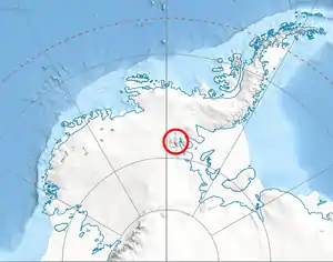 Location of Sentinel Range in Western Antarctica
| |
| Continent | Antarctica |
| Region | Ellsworth Land |
| Range coordinates | 78°10′S 85°30′W |
| Parent range | Ellsworth Mountains |
| Borders on | Heritage Range |
Sentinel Range comprises a main ridge (featuring Vinson Massif in its southern portion) and a number of distinct heights, ridges and mountains on its east side, including (south to north) Petvar Heights, Doyran Heights, Veregava Ridge, Flowers Hills, Sullivan Heights, Barnes Ridge, Maglenik Heights, Probuda Ridge, Bangey Heights, Sostra Heights and Gromshin Heights. It is separated from Bastien Range to the southwest by Nimitz Glacier, and from Heritage Range to the south by lower Minnesota Glacier.
The range was first sighted and photographed from the air on November 23, 1935, by Lincoln Ellsworth who in naming it recognised its prominent position as a landmark on an otherwise featureless ice surface. The range was first visited and partially surveyed in January 1958 during the Sentinel Mountains Traverse led by Charles R. Bentley. The entire range was subsequently mapped by USGS from aerial photography taken by the U.S. Navy, 1958-61.[1][2]
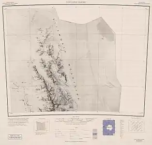 Northern Sentinel Range, USGS map
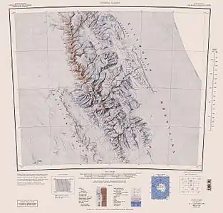 Central and southern Sentinel Range, USGS map
Key mountains and peaks
Maps
- Vinson Massif. Scale 1:250 000 topographic map. Reston, Virginia: US Geological Survey, 1988.
- Newcomer Glacier. Scale 1:250 000 topographic map. Reston, Virginia: US Geological Survey, 1961.
- Antarctic Digital Database (ADD). Scale 1:250000 topographic map of Antarctica. Scientific Committee on Antarctic Research (SCAR). Since 1993, regularly updated.
Features
Geographical features include:
Bangey Heights
Bastien Range
Doyran Heights
Flowers Hills
Gromshin Heights
Maglenik Heights
Owen Ridge
Petvar Heights
Sostra Heights
Sullivan Heights
Veregava Ridge
Other features
- Ahrida Peak
- Allen Peak
- Arzos Peak
- Aster Glacier
- Beadnos Nunatak
- Bender Glacier
- Bohot Nunatak
- Boyce Ridge
- Branscomb Glacier
- Branscomb Peak
- Brichebor Peak
- Brocks Peak
- Bruguière Peak
- Bugueño Pinnacle
- Burdenis Glacier
- Cairns Glacier
- Cervellati Glacier
- Chaplin Peak
- Clinch Peak
- Corbet Peak
- Craddock Massif
- Craig Ridge
- Damien Gildea
- Debren Pass
- Della Pia Glacier
- Delyo Glacier
- Donnellan Glacier
- Doyran Heights
- Drama Glacier
- Duridanov Peak
- Elfring Peak
- Enitsa Peak
- Epperly Ridge
- Evans Peak
- Eyer Peak
- Fisher Nunatak
- Flowers Hills
- Fonfon Glacier
- Frontier Nunataks
- Fukushima Peak
- Galicia Peak
- Gerila Glacier
- Gilbert Spur
- Gildea Glacier
- Giles Glacier
- Goloe Pass
- Goodge Col
- Hammer Col
- Hariton Peak
- Helfert Nunatak
- Hinkley Glacier
- Hollister Peak
- Holth Peaks
- Howard Nunataks
- Ichev Nunatak
- Jacobsen Valley
- Knutzen Peak
- Kovil Nunatak
- Lanz Peak
- Long Gables
- MacDonald Peak
- Marts Peak
- Memolli Nunatak
- Miller Peak
- Minnesota Glacier
- Mount Alf
- Mount Anderson
- Mount Atkinson
- Mount Barden
- Mount Bearskin
- Mount Bentley
- Mount Besch
- Mount Craddock
- Mount Crawford
- Mount Dalrymple
- Mount Davis
- Mount Dawson
- Mount Epperly
- Mount Gardner
- Mount Giovinetto
- Mount Goldthwait
- Mount Hale
- Mount Holmboe
- Mount Hubley
- Mount Jumper
- Mount Liavaag
- Mount Liptak
- Mount Lymburner
- Mount Milton
- Mount Morris
- Mount Osborne
- Mount Ostenso
- Mount Press
- Mount Reimer
- Mount Rutford
- Mount Sharp
- Mount Shear
- Mount Shinn
- Mount Sisu
- Mount Slaughter
- Mount Tegge
- Mount Todd
- Mount Viets
- Mount Wyatt Earp
- Moyher Ridge
- Mursalitsa Peak
- Nell Peak
- Nikola Peak
- Obelya Glacier
- Olsen Peak
- Opalchenie Peak
- Ostrusha Nunatak
- Owen Ridge
- Pastrogor Peak
- Patton Glacier
- Podgore Saddle
- Ponor Saddle
- Príncipe de Asturias Peak
- Progled Saddle
- Rada Peak
- Ramorino Glacier
- Ranuli Ice Piedmont
- Ravulya Nunatak
- Roché Glacier
- Rumyana Glacier
- Saltzman Glacier
- Sanchez Peak
- Schatz Ridge
- Schoening Peak
- Severinghaus Glacier
- Shinn Ridge
- Shockey Peak
- Silverstein Peak
- Silyanov Peak
- Skafida Peak
- Sowers Glacier
- Stolnik Peak
- Strahil Peak
- Taylor Ledge
- Toros Peak
- Tulaczyk Glacier
- Tyree Ridge
- Valchan Peak
- Vanand Peak
- Veregava Ridge
- Versinikia Peak
- Vinson Massif
- Vinson Plateau
- Wahlstrom Peak
- Willis Ridge
- Zalmoxis Peak
- Zapol Glacier
- Zinsmeister Ridge
- Zvegor Saddle
Further reading
External links
- Sentinel Range. Adjusted Copernix satellite image
References
- "Sentinel Range". Geographic Names Information System. United States Geological Survey. Retrieved 2004-11-03.
- Sentinel Range. SCAR Composite Antarctic Gazetteer.
![]() This article incorporates public domain material from websites or documents of the United States Geological Survey.
This article incorporates public domain material from websites or documents of the United States Geological Survey.
| General |
| .svg.png.webp) |
|---|---|---|
| Regions | ||
| Waterways | ||
| Famous explorers | ||