Mount Moriah (New Hampshire)
Mount Moriah is a mountain located in Coos County, New Hampshire. The mountain is part of the Carter-Moriah Range of the White Mountains, which runs along the northern east side of Pinkham Notch. The summit is approximately 5 miles (8 km) southeast of the center of the town of Gorham. Mount Moriah is flanked to the northeast by Middle Moriah Mountain and to the southwest by Imp Mountain. The summit is located on the Appalachian Trail and affords views in all directions.[4]
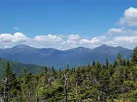
Presidential Range as seen from the summit of Mount Moriah
| Mount Moriah | |
|---|---|
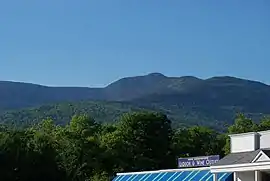 Mt. Moriah (center) from Gorham | |
| Highest point | |
| Elevation | 4,049 ft (1,234 m) [1] |
| Prominence | 922 ft (281 m) [1] |
| Parent peak | North Carter Mountain[1] |
| Listing | AMC New England Hundred Highest[2] |
| Coordinates | 44°20′25″N 71°07′53″W [3] |
| Geography | |
 Mount Moriah | |
| Location | Coös County, N.H., U.S. |
| Parent range | Carter-Moriah Range |
| Topo map | USGS Carter Dome |
References
- "Mount Moriah". Peakbagger.com. Retrieved 2019-07-07.
- "Northeast USA 4000-foot Peaks". Peakbagger.com. Retrieved 2019-07-07.
- "Mount Moriah". Geographic Names Information System. United States Geological Survey. Retrieved 2019-07-07.
- "Mount Moriah". SummitPost.org. Retrieved 2019-07-07.
This article is issued from Wikipedia. The text is licensed under Creative Commons - Attribution - Sharealike. Additional terms may apply for the media files.