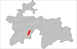
Mu'minobod District
Mu'minobod District or Nohiya-i Mu'minobod (Tajik: Ноҳияи Мӯъминобод) is a district in Khatlon Region, Tajikistan. Its capital is Mu'minobod, in Soviet times, from 1973 − 1991, known as Leningradskiy. The population of the district is 94,700 (January 2020 estimate).[1]
Mu'minobod District
Ноҳияи Мӯъминобод | |
|---|---|
 | |
| Coordinates: 38°06′N 70°02′E | |
| Country | |
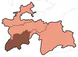
| Region | Khatlon |
| Capital | Mu'minobod |
| Area | |
| • Total | 900 km2 (300 sq mi) |
| Population (2020) | |
| • Total | 94,700 |
| • Density | 110/km2 (270/sq mi) |
| Time zone | UTC+5 |
| • Summer (DST) | UTC+5 |
| Website | muminobod |
Administrative divisions
The district has an area of about 900 km2 (300 sq mi) and is divided administratively into one town and six jamoats.[2] They are as follows:[3]
| Jamoat | Population (Jan. 2015)[3] |
|---|---|
| Mu'minobod (town) | 13,000[4] |
| Balkhobi | 12,590 |
| Boghgay | 13,053 |
| Childukhtaron | |
| Dehibaland | 14,363 |
| Nuralisho Nazarov | 18,733 |
| Shamsiddin Shohin | 10,850 |
Geography
This district is situated in the mountainous southeastern part of Khatlon Region, and is bordering Afghanistan. The district spans 2,387 square kilometers.[5]
History
The district was established in 1973 within Kulob Oblast.[6]
References
- "Population of the Republic of Tajikistan as of 1 January 2020" (PDF) (in Russian). Statistics office of Tajikistan. Retrieved 9 October 2020.
- "Regions of the Republic of Tajikistan 2017" (PDF) (in Russian). Statistics office of Tajikistan. pp. 15–21. Retrieved 12 October 2020.
- Jamoat-level basic indicators, United Nations Development Programme in Tajikistan, accessed 9 October 2020
- "Population of the Republic of Tajikistan as of 1 January 2015" (PDF) (in Russian). Statistics office of Tajikistan. Archived from the original (PDF) on 2 July 2015.
- Historical Dictionary of Tajikistan, Dushanbe, 2010, p. 245
- Historical Dictionary of Tajikistan, Dushanbe, 2010, p. 245
Capital: Qurghonteppa (Bokhtar) | |||||||||||||||||||||||||||||||||||||||||||||||
|  | ||||||||||||||||||||||||||||||||||||||||||||||
|
| |||||||||||||||||||||||||||||||||||||||||||||||
| |||||||||||||||||||||||||||||||||||||||||||||||
This article is issued from Wikipedia. The text is licensed under Creative Commons - Attribution - Sharealike. Additional terms may apply for the media files.