Mudgee
Mudgee /ˈmʌdʒi/ is a town in the Central West of New South Wales, Australia. It is in the broad fertile Cudgegong River valley 261 km (162 mi) north-west of Sydney and the centre of the Mid-Western Regional Council local government area. As at June 2018 its population was 12,410.[1] The district lies across the edge of the geological structure known as the Sydney Basin.[2]
| Mudgee New South Wales | |||||||||
|---|---|---|---|---|---|---|---|---|---|
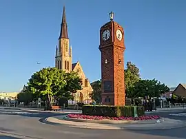 View of the town centre, showing War Memorial Clock Tower | |||||||||
| Population | 12,410 (2018)[1] | ||||||||
| Postcode(s) | 2850 | ||||||||
| Elevation | 454 m (1,490 ft) | ||||||||
| Location |
| ||||||||
| LGA(s) | Mid-Western Regional Council | ||||||||
| County | Wellington | ||||||||
| State electorate(s) | Dubbo | ||||||||
| Federal Division(s) | Calare | ||||||||
| |||||||||
History
Indigenous Australians, pre-colonisation until 1850
In Mudgee the Mowgee clan extended over a 50 km radius centred around the Cudgegong River. Their women's totem was the wedge tail eagle (Mullian) and the men's totem the crow (Waggan).[3]
There are Aboriginal sites, including some with evidence of tool making, and cave paintings. Some of the better known and accessible ones include Hands on the Rocks, The Drip and Babyfoot Cave.
Significance of local names
Some places are named after the local Wiradjuri tribal areas, including Mudgee itself, whose name is derived from the Wiradjuri term Moothi meaning "Nest in the Hills"[4] or "mou-gee" meaning "contented".[5] Others include Lue (Loowee, 'a chain of waterholes'); Gulgong ('a gully'); Wollar ('a rock water hole'); Menah ('flat country'); Eurunderee ('a local tree'); Guntawang ('a peaceful place'), Cooyal ('dry country'); Wilbertree ('a long switch'); Gooree ('native chasing live animal'); Burrendong ('darker than usual'). The Aboriginal name of the Rylstone area was Combamolang.
Settlement to 1850
.jpg.webp)
James Blackman was the first European settler to cross the Cudgegong River in 1821[6] followed quickly by Lieutenant William Lawson who was then commandant of Bathurst. Lawson would later take up 6,000 acres (2,400 ha) in the area.
George and Henry Cox, sons of William Cox, were the first settlers on the Cudgegong River when they established the Menah run, 3 kilometres north of the current town. The European settlers were soon in conflict with the Wiradjuri over a range of issues including the killing of livestock and animals such as kangaroos and possums which were food sources for the Wiradjuri. Martial law was declared by Governor Thomas Brisbane in 1824, leading to the killing of a large number of the Wiradjuri people.[7]
This was mostly organised by the local churches after service, as the Wiradjuri would not give up their totemic religion. As late as the 1930's human skeletal remains were still in trees after a group of Wiradjuri were driven off a cliff on Mt. Misery. This led to another group retaliating by eating a european settler on nearby Cannibal Hill. Misery Mountain is visible from Mudgee town centre as it has the communications towers on the skyline to the South West. It is easily accessible by foot from a track leading from the Southern end of Henry Bailey Drive. Walking from there to Cannibal Hill the significance of the site becomes immediately apparent: there is a single veichle lane width path, perfectly even in width and level, made of volcanic soil, where there is no volcanic plug, from there almost to Avisford, 30 kilometers away. It is faster and easier to walk the distance than along the modern road, due to the cooler temperature at the higher altitude (and the prevailing cool breeze in summer) and the more direct route.
From both Mt. Misery and the nearby hill with the remaining communications towers, from 8am to 9am depending on the time of year, the morning light and shadow clearly outline a pyramid, North, South, East, West, 7 across to 1 high, on the plain just north of Mudgee. No archaeological work has been done at either site.
While the site of Mudgee was surveyed for a village in 1823, the original settlement was Menah, having a police station and lock-up by 1833. It has been incorrectly claimed that Robert Hoddle designed the village which was gazetted in 1838. Although Hoddle was the first surveyor in the region, marking out the boundaries of Putta Bucca and Bombira, by the time the village was gazetted, he had already left the district to become leader of the Port Phillip Survey.[8] John Blackman built a slab hut, the first dwelling in Mudgee and its general store.[9]
By 1841 there were 36 dwellings, three hotels, a hospital, a post office, two stores and an Anglican church. St John's Church of England was consecrated on 6 May 1841.[10] The police station moved from Menah in the mid-1840s and an Anglican school was established in that decade.
1850 to present
In 1851 the population of Mudgee was 200. This skyrocketed with the discovery of gold by Edward Hargraves in nearby Hargraves, leading to a gold rush. While no gold was found in Mudgee itself, the town is central to the goldfields of Gulgong, Hill End and Windeyer, and grew rapidly as a result.
Mudgee was declared as a municipality in 1860 making it the second oldest municipality west of the Great Dividing Range with a population of 1500 in 1861. A public school was built in the 1850s together with the present Anglican, Catholic Methodist and Presbyterian churches. A new police station, courthouse, Mechanics' Institute and a town hall were built in the 1860s. There were four coach factories operating in Mudgee to cater for the demand of the nearby goldfields. The National Trust of Australia has a number of these buildings registered including the Mudgee Museum (formerly the Colonial Inn),[11] the Catholic presbytery, the court house, the police station and the Anglican Church. On 1 June 1861 the Electric Telegraph system arrived and was opened for messages to be transmitted and received at the Telegraph office.[12]
One gold miner attracted to the Mudgee district was Niels Peter Larsen, who married Louisa Albury in Mudgee in 1866. They were the parents of leading Australian poet Henry Lawson in Grenfell in 1867 and changed their names to Peter and Louisa Lawson. By the birth of their third child, they moved to a selection at Pipeclay (now Eurunderee) 8 km north of Mudgee. The site is now a rest stop with a plaque.
Louisa Lawson's vigorous lobbying led to the establishment of the slab-and-bark Eurunderee Public School in 1876 with Henry Lawson first attending aged nine. He would later write about the school in his poem, The Old Bark School. Lawson later attended St. Matthews Central School, Mudgee before progressively worsening deafness led to him leaving school at 14. He lived in the region until age 15 and many of his stories were written about the district.
As the gold petered out in the latter half of the 19th century, Mudgee was sustained by both its wool industry and a nascent wine industry founded by a German immigrant, Adam Roth, in the 1850s. The opening of the railway extension from Rylstone to Mudgee occurred on 10 September 1884.[13][14]
The railway boosted the town's agriculture. The extension between Rylstone and Mudgee closed on 2 March 1992.[14] This same section re-opened eight years later, on 2 September 2000[14] and closed again in 2007. The Wallaby Track Drive Tour visits various sites associated with Lawson including the old Eurundee Public School, the Henry Lawson memorial, the Budgee Budgee Inn, Sapling Gully, Golden Gully and the Albury Pub which was owned by Lawson's grandfather.
In 1890 a local newspaper was founded with the title the Mudgee Guardian and North-Western Representative.[15] Its title changed in 1963 to the Mudgee Guardian and Gulgong Advertiser and is currently published twice a week.
Mudgee's Glen Willow Regional Sports Stadium hosted the 2012 City vs Country Origin rugby league match with an attendance of 8,621, and the 2017 match with an attendance of 8,322.[16] The St. George Dragons regularly host home matches there.[17]
Additionally, in the A-League, the Western Sydney based Western Sydney Wanderers have chosen to take their Community Round match to Mudgee's Glen Willow Regional Sports Stadium, as part of their new Regional Strategy,[18]
In 2014, the local council found itself involved in a statewide corruption investigation when officers of the Independent Commission Against Corruption (New South Wales) raided the local council's offices.[19][20]
Economy
Mudgee has developed as a wine producing region, it has manufacturing and repair industries. It is also heavily dependent on several major mines in the surrounding area[21] and fly-in fly-out (FIFO) miners who live in the town but work elsewhere.
Other rural produce includes cattle, sheep, wheat, alfalfa, olives, fruit, tomatoes, sweetcorn, honey, and dairy products. These, however, do not play as large a role as mining.
The Ulan coal mines are in the district and it also produces marble, pottery clays, shale and dolomite. These mines have further potential to expand in the region, however they attract environmental protests.[22]
Tourism is also a growing industry based mostly on the wineries and, as of 2020, escaping the restrictive life in Sydney. Property prices have surged due to the local airport and the fact that it's only a one hour flight to Sydney.
A laboratory was established in 1987 to test meat for pesticide residues.
Local real estate, petrol and living costs skyrocketed since 2010 when the mining boom began to peak.[23] This has rolled onto the local population, who have since had increased difficulty in living in the town.[24][25]
A new hospital was completed in 2020.
Climate
Mudgee has a humid subtropical climate (Cfa), with semi-arid (Bsk) characteristics. Summers are hot with the occasional thunderstorm. Winters are relatively cold, with frosty mornings and sunny days, interspersed with periods of heavy rain and, rarely, snowfall; Mudgee's heaviest snowfall on record was 56 centimetres (22 in) on 5 July 1900.[26] Rainfall is moderate and falls fairly evenly all year round, with a slight peak in summer. Extreme temperatures have ranged from 43.9 °C (111.02 °F) to –8.3 °C (17.1 °F). The highest monthly rainfall ever recorded was 303.2 mm (11.9 in) of rain in March 1926. Mudgee gets 113.0 clear days, annually.[27]
| Climate data for Mudgee (George Street 1962-2013) | |||||||||||||
|---|---|---|---|---|---|---|---|---|---|---|---|---|---|
| Month | Jan | Feb | Mar | Apr | May | Jun | Jul | Aug | Sep | Oct | Nov | Dec | Year |
| Record high °C (°F) | 42.5 (108.5) |
43.9 (111.0) |
37.2 (99.0) |
34.5 (94.1) |
26.1 (79.0) |
22.8 (73.0) |
22.2 (72.0) |
26.8 (80.2) |
32.2 (90.0) |
38.2 (100.8) |
40.2 (104.4) |
40.6 (105.1) |
43.9 (111.0) |
| Average high °C (°F) | 31.0 (87.8) |
30.2 (86.4) |
27.8 (82.0) |
23.3 (73.9) |
18.8 (65.8) |
15.2 (59.4) |
14.4 (57.9) |
16.0 (60.8) |
19.6 (67.3) |
23.4 (74.1) |
26.9 (80.4) |
29.8 (85.6) |
23.0 (73.4) |
| Average low °C (°F) | 15.5 (59.9) |
15.4 (59.7) |
13.0 (55.4) |
8.5 (47.3) |
5.0 (41.0) |
2.6 (36.7) |
1.3 (34.3) |
2.3 (36.1) |
4.4 (39.9) |
7.6 (45.7) |
10.8 (51.4) |
13.7 (56.7) |
8.3 (46.9) |
| Record low °C (°F) | 3.4 (38.1) |
4.0 (39.2) |
2.0 (35.6) |
−2.7 (27.1) |
−5.6 (21.9) |
−7.5 (18.5) |
−8.3 (17.1) |
−5.7 (21.7) |
−3.2 (26.2) |
−2.3 (27.9) |
0.5 (32.9) |
2.0 (35.6) |
−8.3 (17.1) |
| Average rainfall mm (inches) | 67.7 (2.67) |
63.9 (2.52) |
51.1 (2.01) |
44.2 (1.74) |
49.4 (1.94) |
54.5 (2.15) |
52.9 (2.08) |
53.1 (2.09) |
52.0 (2.05) |
60.0 (2.36) |
62.1 (2.44) |
65.3 (2.57) |
676.2 (26.62) |
| Average rainy days (≥ 0.2mm) | 6.1 | 5.9 | 5.3 | 4.7 | 6.3 | 8.0 | 8.3 | 7.8 | 7.2 | 7.4 | 6.8 | 6.5 | 80.3 |
| Average relative humidity (%) | 40 | 47 | 46 | 50 | 56 | 58 | 57 | 52 | 47 | 45 | 41 | 40 | 48 |
| Source: Bureau of Meteorology[27] | |||||||||||||
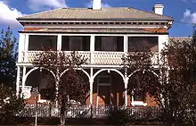
Heritage buildings
Mudgee has a number of heritage-listed sites, including:
- 5-7 Church Street: Regent Theatre[28]
- 13 Church Street: St Mary's Roman Catholic Church[29]
- 64 Market Street: Mudgee Town Hall[30]
- 80 Market Street: Mudgee Post Office[31]
- 111 Lester's Lane: Binnawee Homestead[32]
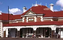
- Wallerawang-Gwabegar railway: Mudgee railway station[33]
Churches
- St John's Anglican Church[34]
- St Mary's Catholic Church[35]
- St Paul's Presbyterian Church[36]
- Mudgee Uniting Church[37]
- Frontline Assemblies of God[38]
- Mudgee Baptist Church[39]
- Salvation Army[40]
- Seventh Day Adventist Church[41]
Schools and colleges
- Cudgegong Valley Public School[42]
- Mudgee High School
- Mudgee Public School[43]
- St Matthews Catholic School[44]
- Mudgee College[45] (TAFE)
Gallery
 Commercial building in town
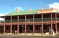 Lawson Park Hotel
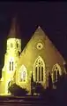 Presbyterian Church at night
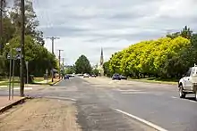
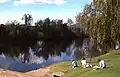 Cudgegong River where it passes close to the town
Notable people
- Natarsha Belling – national newsreader for Channel 10
- Felicity Brown – milliner
- Aaron Downes – professional soccer player
- Jamie Fitzgerald – former professional rugby league footballer who played 71 First Grade NRL games
- Darrell Hair – international cricket umpire
- Lisa Keightley – cricketer, first woman to score a century at Lord's in England
- Henry Lawson – one of Australia's most recognised poets and short story writers. Lived in Mudgee for 16 years during childhood after his birth in Grenfell
- Louisa Lawson – mother of Henry Lawson and prolific activist
- David Lowe – Winemaker and owner Lowe Wines, President NSW Wine Industry Association, Vice President Australian Winemakers Federation
- Kim Currie – Chef and owner of hatted Zin House restaurant, Winner of NSW Rural Woman of the Year 2009[46]
- Scott McGregor – Australian actor, TV presenter and railway historian
- Ted Noffs – Methodist minister and founder of the Wayside Chapel in Kings Cross 1964
- James Stanton - Olympic water polo player for Australia.
- Ken Sutcliffe – television personality, sports reader for Channel Nine
- Dennis Talbot – professional boxer who represented Australia in the 1972 Olympics in Munich
- Groups
- Brothers3 – X-Factor contestants, 2014
See also
References
- "3218.0 – Regional Population Growth, Australia, 2017-18: Population Estimates by Significant Urban Area, 2008 to 2018". Australian Bureau of Statistics. Australian Bureau of Statistics. 27 March 2019. Retrieved 22 April 2019. Estimated resident population, 30 June 2018.
- Sydney Basin (Map). New South Wales Department of Primary Industries.
- "Bundyi Aboriginal Culture Knowledge Tours & Online Shop – Aboriginal culture tours, Walking tour around central Wagga Wagga and Wiradjuri cultural places. Aboriginal online store". Retrieved 12 June 2019.
- "Mudgee". Geographical Names Register (GNR) of NSW. Geographical Names Board of New South Wales. Retrieved 30 July 2013.

- "PLACE NAMES". The Australian Women's Weekly. National Library of Australia. 13 May 1964. p. 61. Retrieved 22 February 2011.
- Greaves, Bernard. "Blackman, James (1792–1868)". Australian Dictionary of Biography. National Centre of Biography, Australian National University. Retrieved 9 December 2013.
- "Transcript: Declaration of Martial Law". nma.gov.au. Retrieved 26 September 2016.
- "Mudgee Guardian". Retrieved 11 June 2017.
- Yap, Brian. "John Blackman". Freepages. Ancestry.com. Retrieved 9 December 2013.
- "ST. JOHN'S, MUDGEE". Mudgee Guardian and North-western Representative. New South Wales, Australia. 4 June 1936. p. 10. Retrieved 31 October 2017 – via National Library of Australia.
- "Colonial Inn Museum". Mudgee Historical Society Inc. Retrieved 15 November 2011.
- Annette Piper (1 June 1861). "Western Post June 1861". Western Post. Retrieved 14 March 2011.
- "THE EXTENSION OF THE RAILWAY TO MUDGEE". The Sydney Morning Herald. National Library of Australia. 9 September 1884. p. 5. Retrieved 15 November 2011.
- Bozier, Rolfe. "Gwabegar Line". NSWrail.net. Retrieved 15 November 2011.
- Mudgee Guardian and North-Western Representative, trove.nla.gov.au. Retrieved 23 November 2019.
- Chammas, Michael (23 April 2012). "Classy Carney closes on Origin spot with sizzling show". Brisbane Times. Retrieved 29 April 2012.
- https://www.dragons.com.au/news/2018/10/19/dragons-announce-mudgee-fixtures-for-2019/
- https://www.wswanderersfc.com.au/news/wanderers-take-community-round-match-mudgee-part-new-regional-strategy
- "ICAC searches Mid-Western Regional Council offices in Mudgee". ABC News. Retrieved 13 November 2015.
- "Mid-Western Council abandons extraordinary meeting over ICAC inquiry". MudgeeGuardian.com. Retrieved 13 November 2015.
- "Mudgee". Visit NSW. Retrieved 18 May 2013.
- "People's rally protests Mudgee conference | Beyond Zero Emissions". bze.org.au. Retrieved 13 November 2015.
- "Petrol prices down but Mudgee still among most expensive towns to fill up". Mudgee Guardian. Retrieved 14 November 2015.
- "If everyone thinks it's a bubble, it probably isn't". ABC News. Retrieved 14 November 2015.
- "Australia has to face up to the facts on coal". The Australian.
- "5 July 1900 Snowstorm" (PDF).
- "MUDGEE (GEORGE STREET)". Climate statistics for Australian locations. Bureau of Meteorology. April 2013. Retrieved 27 April 2013.
- ""Regent Theatre" | NSW Environment, Energy and Science". www.environment.nsw.gov.au. Retrieved 21 March 2020.
- "St. Mary's Roman Catholic Church, Presbytery, Convent & Hall". New South Wales State Heritage Register. Office of Environment and Heritage. H00685. Retrieved 18 May 2018.
- "Mudgee Town Hall". New South Wales State Heritage Register. Office of Environment and Heritage. H00464. Retrieved 18 May 2018.
- "Mudgee Post Office & Quarters". New South Wales State Heritage Register. Office of Environment and Heritage. H01314. Retrieved 18 May 2018.
- "Binnawee Homestead and Outbuildings". New South Wales State Heritage Register. Office of Environment and Heritage. H01780. Retrieved 18 May 2018.
- "Mudgee Railway Station, yard and locomotive yard". New South Wales State Heritage Register. Office of Environment and Heritage. H01204. Retrieved 18 May 2018.
- "St John's Anglican Church Mudgee P.1". Mudgeehistory.com.au. 9 July 2012. Retrieved 25 December 2012.
- "Mudgee Catholic Church :: Home". Mudgee.catholic.org.au. Retrieved 25 December 2012.
- "Mudgee, St Paul's Presbyterian Church – Find a Presbyterian Church". Findapresbyterianchurch.com. Retrieved 25 December 2012.
- "Uniting Church Mudgee and Rylstone".
- "Contact Us". Frontline.org.au. Retrieved 25 December 2012.
- Maps, Google. "Google Maps". Google. Retrieved 7 May 2013.
- Jones, Andrew (16 October 2012). "Mudgee Corps ť". My.salvos.org.au. Archived from the original on 27 November 2012. Retrieved 25 December 2012.
- "Mudgee Seventh-day Adventist Church – Home". Mudgee.adventist.org.au. Retrieved 25 December 2012.
- Cudgegong Valley Public School in All Our Best. "Home". Cudgegongv-p.schools.nsw.edu.au. Retrieved 25 December 2012.
- "Mudgee Public School". Mudgeepublic.com.au. Retrieved 25 December 2012.
- "St Matthews Central School Mudgee NSW Australia". Stmattsmudgee.nsw.edu.au. 30 March 2012. Archived from the original on 24 April 2013. Retrieved 25 December 2012.
- "Mudgee College : TAFE Western". Wit.tafensw.edu.au. Retrieved 25 December 2012.
- "State recognition for inspirational women | NSW Department of Primary Industries". www.dpi.nsw.gov.au. Retrieved 5 February 2021.
External links
| Wikivoyage has a travel guide for Mudgee. |
| Wikimedia Commons has media related to Mudgee. |
- "Mudgee Chamber of Commerce".
- "Mudgee District Local History".
- "Mudgee". visitnsw.com.
- "Mudgee Video from the air".
| Authority control |
|---|