Wellington County, New South Wales

Wellington County is a county in New South Wales, Australia, which was one of the original Nineteen Counties. The town of Wellington is near the north-eastern edge. The Bell River is the boundary to the west, and the Cudgegong River to the north. It includes land on both sides of the Macquarie River.

Wellington
New South Wales
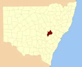
Location in New South Wales
Lands administrative divisions around Wellington:
Gordon Bligh Phillip
Ashburnham Wellington Roxburgh
Ashburnham Bathurst Roxburgh

It contains the town of Mudgee, where the first house was stated to have been built in 1837 by John Blackman.

There is a modern-day local government area called just "Wellington Council".

Wellington County was named in honour of Arthur Wellesley, Duke of Wellington (1769-1852).[1]

Parishes within this county

A full list of parishes found within this county; their current LGA and mapping coordinates to the approximate centre of each location is as follows:

ParishLGACoordinates
AvisfordMid-Western Regional Council32°44′54″S 149°30′04″E
BiraganbilMid-Western Regional Council32°24′54″S 149°25′04″E
BodulduraDubbo Regional Council32°52′54″S 149°06′04″E
BoigaMid-Western Regional Council32°53′54″S 149°30′04″E
BoomeyCabonne Shire32°57′54″S 148°57′04″E
BoomeyCabonne Shire32°59′54″S 149°00′04″E
BorenoreCabonne Shire33°14′54″S 149°02′04″E
BroombeeMid-Western Regional Council32°40′54″S 149°39′04″E
BurrendongDubbo Regional Council32°43′54″S 149°06′04″E
CanningDubbo Regional Council32°38′54″S 149°16′04″E
CarrollBathurst Regional Council32°59′54″S 149°30′04″E
CarrollMid-Western Regional Council32°58′54″S 149°28′04″E
CoolaminDubbo Regional Council32°59′54″S 149°11′04″E
CooperDubbo Regional Council32°52′54″S 149°04′04″E
CooperDubbo Regional Council32°52′54″S 148°59′04″E
Copper HillCabonne Shire32°58′54″S 148°52′04″E
CummingsMid-Western Regional Council32°57′54″S 149°24′04″E
CunninghamBathurst Regional Council33°00′54″S 149°35′04″E
CurragurraDubbo Regional Council32°51′54″S 149°10′04″E
ErudgereMid-Western Regional Council32°31′54″S 149°27′04″E
ForbesCabonne Shire33°02′54″S 149°14′04″E
GalwadgereDubbo Regional Council32°38′54″S 148°59′04″E
GamboolaCabonne Shire33°08′54″S 149°00′04″E
GrattaiMid-Western Regional Council32°41′54″S 149°27′04″E
HargravesMid-Western Regional Council32°44′54″S 149°27′04″E
IronbarksDubbo Regional Council32°47′54″S 148°59′04″E
KerrMid-Western Regional Council32°43′54″S 149°20′04″E
Larras LakeCabonne Shire33°02′54″S 149°03′04″E
LewisCabonne Shire33°07′54″S 149°12′04″E
MarchCabonne Shire33°13′54″S 149°08′04″E
MerindaMid-Western Regional Council32°33′54″S 149°19′04″E
MillenbongMid-Western Regional Council32°41′54″S 149°22′04″E
MuckerwaDubbo Regional Council32°48′54″S 149°10′04″E
MudgeeMid-Western Regional Council32°37′54″S 149°33′04″E
MulyanCabonne Shire33°05′54″S 149°03′04″E
MumbilDubbo Regional Council32°39′54″S 148°58′04″E
MunnaMid-Western Regional Council32°32′54″S 149°32′04″E
NubrigynDubbo Regional Council32°55′54″S 149°01′04″E
OrangeCabonne Shire33°16′54″S 149°04′04″E
PetersMid-Western Regional Council32°56′54″S 149°28′04″E
PiambongMid-Western Regional Council32°28′54″S 149°24′04″E
RouseMid-Western Regional Council32°27′54″S 149°17′04″E
SuttorDubbo Regional Council32°42′54″S 149°14′04″E
TambarooraBathurst Regional Council33°02′54″S 149°23′04″E
TannabuttaMid-Western Regional Council32°43′54″S 149°44′04″E
TatualiMid-Western Regional Council32°52′54″S 149°22′04″E
Three RiversCabonne Shire32°57′54″S 148°54′04″E
ToolamanangMid-Western Regional Council32°50′54″S 149°40′04″E
TowacCabonne Shire33°17′54″S 149°00′04″E
TriambleMid-Western Regional Council32°51′54″S 149°17′04″E
TrudgettDubbo Regional Council33°00′54″S 149°07′04″E
TunnabidgeeMid-Western Regional Council32°55′54″S 149°32′04″E
UlmarrahMid-Western Regional Council33°00′54″S 149°18′04″E
WaltersDubbo Regional Council32°44′54″S 149°14′04″E
WarneDubbo Regional Council33°00′54″S 149°03′04″E
WarratraMid-Western Regional Council32°43′54″S 149°41′04″E
WaurdongMid-Western Regional Council32°53′05″S 149°26′49″E
WearDubbo Regional Council32°39′54″S 149°10′04″E
WellingtonDubbo Regional Council32°36′54″S 148°57′04″E
WeroueraMid-Western Regional Council32°37′54″S 149°25′04″E
WiadereMid-Western Regional Council32°27′54″S 149°20′04″E
WindeyerMid-Western Regional Council32°46′54″S 149°30′04″E

References

  1. "Wellington". Geographical Names Register (GNR) of NSW. Geographical Names Board of New South Wales. Retrieved 11 August 2013.
This article is issued from Wikipedia. The text is licensed under Creative Commons - Attribution - Sharealike. Additional terms may apply for the media files.