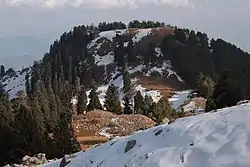
Mukeshpuri
Mukshhpuri (مکیشپوری ) is a 2,800-metre-high (9,200 ft) mountain in the Nathia Gali Hills, in the Abbottabad District of the Khyber Pakhtunkhwa province in northern Pakistan. It is 90 kilometres (56 mi) north of Islamabad, just above Dunga Gali in the Nathia Gali area of Ayubia National Park. It is the second highest peak in the Galyat Region after Miranjani which is located at 2,992 metres (9,816 ft).[1] Much of it the mountain is covered with Western Himalayan subalpine conifer forests.[2]
Mukshpuri | |
|---|---|
 Snowy Mountains of Mukshpuri | |
 Mukshpuri  Mukshpuri | |
| Coordinates: 34°04′N 73°23′E | |
| Country | |
| Province | Khyber Pakhtunkhwa |
| District | Abbottabad District |
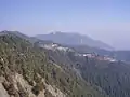
The peak
The route from Nathia Gali on western side of mountain is a steady and 4-kilometre-long (2.5 mi) climb. The mountain also has a route on the Dunga Gali side, with a steeper slope. There is a bird sanctuary on this side created with the help of the European Union.
From the top of Mukeshpuri peak, on the eastern edge of Khyber Pakhtunkhwa, the following areas can be seen: — Circle Bakote, Jhelum River, the Bagh District of Azad Kashmir, in the south the city of Murree and the Murree Tehsil, as well as Islamabad.[3]
Gallery
 Mukeshpuri mountain and the Nathia Gali in Ayubia National Park
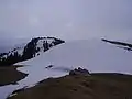 The top of Mukeshpuri peak
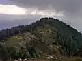 View from Mukeshpuri
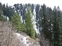 Conifer forests on the mountain.
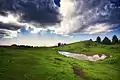 Mushkpuri Top
See also
- List of mountains in Pakistan
- Galyat region - the local region and its towns
- Muree - adjacent in the Rawalpindi District
| Wikimedia Commons has media related to Mukeshpuri. |
References
- "Mukshpuri or Mukshpuri - A Guide for Travelers". thetourist.pk. Retrieved 23 October 2018.
- "Location and Covered with Western Himalayan Subalpine Conifer Forests". Bhattiadil.wordpress.com. Retrieved 21 June 2018.
- "Areas which can be seen from Mukeshpuri Top". www.pakistantoursguide.pk. Retrieved 20 June 2018.
External links
 Murree travel guide from Wikivoyage
