Bagh District
The Bagh District (Urdu: ضلع باغ) is one of the ten districts of Pakistan's dependent territory of Azad Kashmir. The district, which had previously been part of the Poonch District, was created in 1988.[2]
Bagh District
ضلع باغ | |
|---|---|
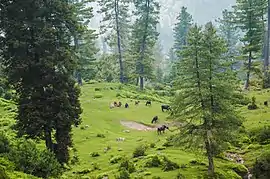 Ganga Choti, Bagh District, Azad Kashmir | |
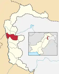 Map of Azad Kashmir with the Bagh District highlighted in red | |
| Sovereign state | |
| Dependent territory | |
| Division | Poonch Division |
| Headquarters | Bagh |
| Area | |
| • Total | 770 km2 (300 sq mi) |
| Population (2017) | |
| • Total | 371,919 |
| • Density | 483/km2 (1,250/sq mi) |
| Number of tehsils | 3 |
The Bagh District is bounded on the north by the Muzaffarabad District, the Hattian Bala District, and the Baramulla District of Indian-administered Jammu and Kashmir, on the east by the Haveli District, on the south by the Poonch District, and on the west by the Rawalpindi District of Pakistan's Punjab Province. The total area of the district is 770 square kilometers.[3] The Bagh District is linked to the Muzaffarabad District by two roads, one via Sudhan Gali (80 km) and the other via Kohala (97 km). The district headquarters is the city of Bagh, which is situated 46 km from Rawalakot. It is said that a bagh (garden) was set up by a landowner where the premises of the Forest Department are now located. As a result, the area that is now the district headquarters was named "Bagh".[4][5]
History
There is an archaeological site in the Bagh District called Bagh Fort.[6]
Prior to 1947, Bagh was a tehsil in the Poonch District of Jammu and Kashmir.[7]
Administrative divisions
The district of Bagh is subdivided into 3 tehsils:[1]
- Bagh Tehsil
- Dhirkot Tehsil
- Hari Ghel Tehsil
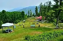
Geography and climate
Topographically, the entire Bagh District is a mountainous area, generally sloping from north-east to south-west. The area is part of the Lesser Himalayas zone. The main mountain range in the district is the Pir Panjal.
The Haji-Pir Pass is situated at a height of 3421 meters above sea level. The general elevation is between 1500 and 2500 meters above sea level. The mountains are generally covered with coniferous forests. The main river in the district is the Mahl Nala, but numerous other rivulets also flow in the district.[8]
The climate of the district varies with altitude. The temperature generally remains between 2 °C and 40 °C. The main eastern part of the district is very cold in the winter and moderate in the summer. However, the lower valleys, the localities bordering Bagh at Kohala and its adjoining areas (Mongbajri and Ajra-Bagh) remain cold in the winter and hot in the summer. May, June, and July are the hottest months. The maximum and minimum temperatures during the month of June are about 40 °C and 22 °C, respectively. December, January, and February are the coldest months. The maximum temperature in January is about 16 °C, and the minimum temperature is 3 °C. Annual rainfall is about 1,500 millimetres (59 in).[8]
Demography
The total population of the district according to the 2017 census is 371,919.[9]
The major language of Azad Kashmir is Pahari. The Pahari dialect spoken in Bagh is closely related to the dialect spoken to the north in the Muzaffarabad (84% shared basic vocabulary) and to the core Pahari varieties spoken to the south-west in the Galyat region around Murree (86–88%).[10]
Education
According to the Pakistan District Education Ranking 2017, a report by Alif Ailaan, the Bagh District is ranked at number 5 nationally in the ranking related to education, with an education score of 73.99. The learning score is at 85.42, with a gender parity score of 88.32.[11]
The school infrastructure score of the Bagh District is 28.32, giving Bagh a national rank of 126.[11] School infrastructure is a major problem in all of Azad Kashmir. Access to schools, with schools being far away, is the primary reason why there are fewer enrollments after the completion of primary school.
2005 earthquake
The city of Bagh, like other areas of the district, was heavily damaged in the 2005 Kashmir earthquake. Sixty percent of the buildings collapsed. Thousands of people died, and many more found themselves homeless. In the aftermath of the earthquake, NATO sent specialists to the district to help with clearing and reconstruction.[12] There was a report that an entire village in the district had been wiped out.[13] The United States government, through Pakistan, distributed vouchers to people in the district so that they could buy food and water.[14]
References
- "Bagh District on AJK map". ajk.gov.pk. AJK Official Portal. Retrieved 17 November 2019.
- Government of Azad Kashmir
- Bagh District Statistics
- "AJ&K Official Portal". www.ajk.gov.pk.
- "Archived copy" (PDF). Archived from the original (PDF) on 2015-09-24. Retrieved 2010-01-18.CS1 maint: archived copy as title (link)
- Archived 2011-02-09 at the Wayback Machine
- Snedden, Christopher (2015), Understanding Kashmir and Kashmiris, Oxford University Press, p. xxi, ISBN 978-1-84904-342-7
- "Archived copy" (PDF). Archived from the original (PDF) on 2015-09-24. Retrieved 2010-01-18.CS1 maint: archived copy as title (link)
- "Census 2017: AJK population rises to over 4m". The Nation. Retrieved 2017-09-01.
- Lothers, Michael; Lothers, Laura (2010). Pahari and Pothwari: a sociolinguistic survey (Report). SIL Electronic Survey Reports. 2010–012. p. 24. The wordlist for these comparisons was collected in Neela Butt.
- "Pakistan District Education Rankings 2017" (PDF). elections.alifailaan.pk. Alif Ailaan. Archived from the original (PDF) on 30 July 2018. Retrieved 17 November 2019.
- "Nato winds up Kashmir relief work". January 31, 2006 – via news.bbc.co.uk.
- "Strong quake rocks Indian subcontinent". ABC News. October 8, 2005.
- "Pakistan Earthquake Families to Receive $100 Vouchers (Update1)". Bloomberg.com. Archived from the original on 4 June 2011. Retrieved 5 March 2017.
External links
- Bagh Azad Jammu and Kashmir Official Portal
- District Profile – Bagh Earthquake Reconstruction & Rehabilitation Authority (ERRA) 2007
| Wikimedia Commons has media related to Bagh District. |
Provincial capital: Muzaffarabad | ||
| Muzaffarabad | 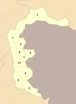 | |
| Poonch | ||
| Mirpur | ||