Mullalyup, Western Australia
Mullalyup is a town in the South West region of Western Australia, situated between Kirup and Balingup on the South Western Highway, 231 kilometres (144 mi) south of Perth. The town is in the shire of Donnybrook-Balingup, known for its scenic Blackwood River Valley and agricultural industries.[2]
| Mullalyup Western Australia | |
|---|---|
 Mullalyup | |
| Coordinates | 33.74°S 115.95°E |
| Population | 275 (2006 census)[1] |
| Established | 1901 |
| Postcode(s) | 6252 |
| Elevation | 133 m (436 ft) |
| Location |
|
| LGA(s) | Shire of Donnybrook-Balingup |
| State electorate(s) | Warren-Blackwood |
| Federal Division(s) | Forrest |
The name is taken from the nearby Mullalyup Brook, and was first noted by John Forrest in 1898. It is Noongar in origin, and apparently means "nose place", as the place where nose-piercing was performed as part of the initiation cycle of young men.[3]
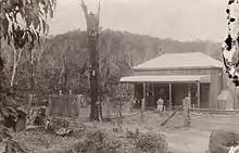
The first Europeans to settle in the area were the Coverley family who took land close to the town and named their farm "Elm Grove". The first major building in the town was the Blackwood Inn, built in 1882 by John Coverley for Thomas Maslin.
During the 1890s the town was included as a siding in the construction of the railway line from Donnybrook to Bridgetown.[4]
The town site was gazetted in 1901.[5]
References
- Australian Bureau of Statistics (25 October 2007). "Mullalyup (State Suburb)". 2006 Census QuickStats. Retrieved 16 September 2008.
- "South West Development Commission - Shire of Donnybrook-Balingup".
- Western Australian Land Information Authority. "History of country town names – M". Retrieved 24 January 2007.
- "Balingup Community Web - Mullalyup". 2007. Archived from the original on 18 July 2008. Retrieved 16 September 2008.
- "About Australia - Mullalyup, WA". 2007. Archived from the original on 11 October 2008. Retrieved 16 September 2008.